
lovethailand home >South Travel Attractions >Yala Travel Attractions >Than To >Than To > Than To Lake
TL;DR: Than To Lake is located at Upper reservoir area of Bang Lang Dam, covering parts of Than To District, Yala Province, and connected areas near the Narathiwat, open Daily, hours Open throughout the day for roadside viewpoints and publicly accessible lake.

Than To Lake
Open Days: Daily
Opening Hours: Open throughout the day for roadside viewpoints and publicly accessible lake areas along the travel route
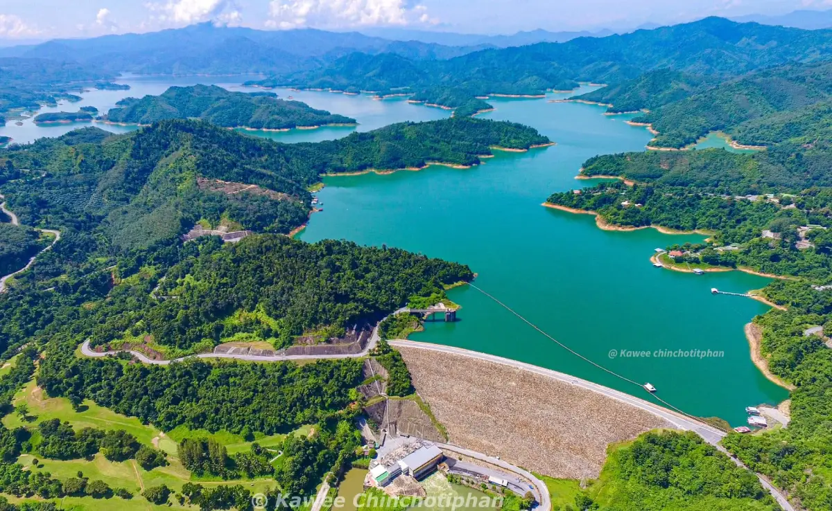
Than To Lake in Yala Province is a mountain reservoir formed by the construction of Bang Lang Dam, a hydropower and multipurpose dam on the Pattani River. The lake spreads across Than To District and connects with the wider Bang Lang reservoir landscape, forested mountains, freshwater fisheries, and water-based nature study routes. It is one of the most scenic points on the Yala-Betong route, especially around Mae Wat Subdistrict and To Ku Chae-Kho Yae Bridge, where travelers can see a broad green lake surrounded by tropical forest and mountains.
Than To Lake is one of the most distinctive natural attractions in Than To District, Yala Province. The lake lies in the upper reservoir area of Bang Lang Dam, a major hydropower and water-management project built across the Pattani River. When water was stored behind the dam, parts of the former valley landscape became a large mountain lake. Today, Than To Lake is known for its broad water surface, forested hills, islands, freshwater fish, community stories, and scenic road viewpoints along Highway 410 between Yala and Betong.
The landscape around Than To Lake is one of the strongest reasons to visit. The area is surrounded by complex mountain terrain, humid tropical forest, streams, waterfalls, and communities located along valleys and roads. Travelers driving along Highway 410 will often see the lake appear between mountain curves, especially around Mae Wat Subdistrict and To Ku Chae-Kho Yae Bridge. This bridge is one of the easiest places to stop, rest, take photographs, and enjoy a wide view of the water before continuing toward Betong.
Than To Lake is directly connected to Bang Lang Dam. The dam was built to generate electricity, support irrigation, reduce flooding in the Pattani River Basin, and create an important freshwater fishery for the southern region. The water stored above the dam forms a large reservoir area, and the section associated with Than To District is widely known as Than To Lake. In some travel contexts, the surrounding lake-and-forest landscape is also associated with the Hala-Bala lake scenery because of its close relationship with the Hala-Bala forest ecosystem.
The lake is often described as a mountain lake in southern Thailand. Local information describes it as approximately 2 km wide and 6 km long, with many small and large islands scattered across the water. These islands make the view especially striking. From the roadside viewpoint or bridge, visitors can see green water framed by forested slopes and layered mountains. On clear days, the lake reflects the sky and hills beautifully; after rain, mist may drift above the water and give the scenery a quieter, more atmospheric character.
Than To Lake also has a strong local-history dimension. Before Bang Lang Dam was built, parts of the Mae Wat and Than To areas were home to older communities such as Ban Mae Wat, Ban To, and Ban Yo. When water was stored behind the dam, some original communities had to move to higher ground. The story of Ban To, often remembered as an old settlement now associated with the underwater landscape of Bang Lang reservoir, remains an important part of local memory. This gives Than To Lake a deeper meaning beyond scenery: it is also a place shaped by community change.
When water levels drop significantly in some years, traces of former settlement areas and old structures can occasionally become visible. These moments remind local residents and visitors that the lake covers places where people once lived, worked, traded, and traveled. A visit to Than To Lake therefore carries two layers of meaning: the beauty of water and mountains above the surface, and the memory of communities and routes that existed before the reservoir was created.
The lake is also important as a freshwater fishery. Communities around the reservoir use the water for small-scale fishing and local livelihoods. Fish from the lake support food culture and local products in Than To District. For this reason, visitors should view the lake respectfully. The water is not only a scenic background for photographs; it is a resource that supports real households, local food, and community life.
For nature lovers, Than To Lake works as a water-based nature classroom. The upper reservoir connects water, rainforest, streams, islands, and the wider Bang Lang-Hala-Bala natural landscape. Some boat routes allow visitors to see forested shorelines, mist over the water, islands, and birds living along the lake edge. Hornbills are especially meaningful in this region because they are associated with healthy tropical forest. This makes a boat trip across the reservoir more than simple sightseeing; it is a way to understand how water, forest, and wildlife are connected.
To Ku Chae-Kho Yae Bridge in Mae Wat Subdistrict is one of the most accessible viewpoints for Than To Lake. The bridge crosses the Bang Lang reservoir area on the Yala-Betong road. From the bridge and nearby stopping points, travelers can see a wide stretch of green water, forested mountains, and a quiet southern-border landscape. Morning and late afternoon are the best times for viewing and photography because the light is softer and the scenery has more depth.
Than To Lake is closely tied to the identity of Than To District, which is known for the idea of a large lake in the valley. The phrase captures the unusual character of the place well. This is not a sea coastline, but a wide inland body of water surrounded by mountains. The result is a landscape that feels like a hidden inland sea in southern Thailand, shaped by water, mist, forest, and local communities.
For route planning, Than To Lake is best included as part of a Yala-Betong road trip. Travelers can leave Yala city, follow Highway 410 through Bannang Sata District into Than To District, stop around Mae Wat and To Ku Chae-Kho Yae Bridge, then continue toward Betong or Aiyerweng Skywalk. This route offers a strong mix of mountain driving, lake viewpoints, rainforest scenery, waterfalls, local communities, and deep-south cultural landscapes.
Travelers with limited time can spend 15 to 30 minutes at a roadside viewpoint to take photos and rest. Those who want a fuller experience should allow half a day or a full day to combine the lake with a boat trip, local food, Than To Waterfall, Bang Lang National Park, or nearby accommodation. A slower visit reveals more of the lake’s character, including its role in local life and its connection to the wider Bang Lang reservoir system.
Recommended activities include scenic viewing, road-trip photography, reservoir boat trips, water-based nature study, bird watching along the forested shoreline, and learning about the former communities affected by the creation of the reservoir. Boat trips should be arranged with local operators in advance. Operating conditions depend on the departure point, weather, water level, and safety readiness. Travelers should wear life jackets during all boat activities and avoid boating during heavy rain, strong wind, or poor visibility.
The best time to visit Than To Lake is in the morning or late afternoon. Morning visits are good for mist and calm water, while late afternoon gives warmer light and softer scenery. During the rainy season, the forested mountains become especially green, but drivers should be more careful because the Yala-Betong road has curves and can become slippery. During the drier months, water levels may reveal shorelines, islands, and landforms that are usually hidden.
Than To Lake is excellent for documentary-style travel photography. Good subjects include the bridge over the water, mountain layers, small islands, local boats, misty mornings, and reflections on the lake surface. Visitors taking photographs from a bridge should not stand in the road, climb railings, or park in a way that obstructs traffic. Highway 410 remains an important local road, so safety should come before photography.
The cultural setting around Than To Lake is also worth noticing. Than To District is home to Buddhist, Muslim, Chinese-Thai, and migrant communities that settled in different periods. This creates a diverse local culture of food, language, beliefs, and daily life. Visitors should dress modestly, behave politely, avoid photographing people or houses without permission, and keep the lakeside and viewpoints clean.
Than To Lake connects easily with several nearby attractions. To Ku Chae-Kho Yae Bridge is the most convenient viewpoint. Ta Pha Yao Pier and Mae Wat Subdistrict connect to water-based travel in some areas. Than To Waterfall and Bang Lang National Park offer forest and waterfall experiences. Bang Lang Dam provides a closer look at the engineering and hydropower side of the reservoir system. Aiyerweng Skywalk and Betong can also be added to a longer scenic route.
For families, Than To Lake is best as a viewpoint and rest stop rather than a strenuous outdoor activity. Children and older travelers can enjoy the scenery from accessible roadside areas, while more active travelers can add boating or waterfall visits. Anyone traveling with children should keep them away from road edges, railings, steep banks, and the waterline.
Food and accommodation options are available along the Than To, Mae Wat, Bang Lang Dam, and Yala-Betong route. Around Than To, travelers can find local restaurants, cafés, halal food, and nature-style accommodation. Those who want more choices can stay in Yala city, Bannang Sata, or Betong and visit Than To Lake during the day. Staying closer to the lake is better for travelers who want nature and quiet scenery, while staying in town is better for convenience and transport access.
Important safety points include weather, road conditions, and water safety. Than To is a mountainous area with frequent rain in many months of the year. Travelers should check the weather, drive at a suitable speed, and be careful on curves and wet road surfaces. At viewpoints, park safely and do not obstruct traffic. For boat trips, choose operators with proper safety equipment and avoid swimming in areas that are not clearly designated as safe.
Useful items to bring include comfortable shoes, drinking water, sun protection, rain protection during the wet season, a bag for carrying trash back, and a camera. Groups should agree on meeting points and travel times because phone signal can be uneven in some mountainous areas. With simple preparation, a visit to Than To Lake can be safe, smooth, and highly rewarding.
Getting There from Yala city is straightforward by road. Take Highway 410, the Yala-Betong route, through Bannang Sata District into Than To District. Continue toward Mae Wat Subdistrict and To Ku Chae-Kho Yae Bridge, one of the most accessible viewpoints over Than To Lake. The distance from Yala city to Than To District is about 60 km, and the route continues toward Betong through mountain and reservoir scenery. Travelers without a private vehicle can use the Yala-Betong public transport route and arrange local transport for viewpoint stops.
Overall, Than To Lake is one of the most meaningful places to include in a Yala travel plan. It combines water, forest, mountains, local history, fisheries, hydropower development, and road-trip scenery in one landscape. Travelers can stop briefly for photographs, spend more time exploring the reservoir, or connect the lake with waterfalls, Bang Lang Dam, Aiyerweng, and Betong. For anyone who wants to understand Yala beyond the city center, Than To Lake offers one of the clearest views of the province’s natural and cultural depth.
| Name | Than To Lake |
| Location | Upper reservoir area of Bang Lang Dam, covering parts of Than To District, Yala Province, and connected areas near the Narathiwat provincial side |
| Address | Mae Wat Subdistrict, Than To District, Yala 95170, Thailand |
| Reference Coordinates | Ban To underwater historical area, Mae Wat Subdistrict: Latitude 6.0468173, Longitude 101.1670884 |
| Highlights | Mountain reservoir above Bang Lang Dam, To Ku Chae-Kho Yae Bridge viewpoint, islands, boat routes, freshwater fisheries, and Hala-Bala forest scenery |
| History | Formed by water storage above Bang Lang Dam after the hydropower and water-management project was built across the Pattani River, turning parts of the former valley and community areas into a large mountain lake |
| Name Origin | The name is associated with Than To District and its identity as a large body of water in a mountain valley |
| Distinctive Features | Mountain lake above Bang Lang Dam, about 2 km wide and 6 km long, with many islands and striking views of water, rainforest, and mountains |
| Importance | Freshwater fishery, water-based nature study area, scenic stop on the Yala-Betong route, and a landscape linked to Bang Lang Dam, Bang Lang National Park, and Hala-Bala forest |
| Travel Information | From Yala city, take Highway 410 toward Betong, pass Bannang Sata into Than To District, then stop around Mae Wat Subdistrict and To Ku Chae-Kho Yae Bridge for lake views |
| Current Status | Active reservoir landscape above Bang Lang Dam, used for water resources, fisheries, scenic travel, roadside viewpoints, and water-based nature tourism |
| Open Days | Daily |
| Opening Hours | Open throughout the day for roadside viewpoints and publicly accessible lake areas along the travel route |
| Facilities | Roadside viewpoints, selected rest areas, Yala-Betong highway access, boat piers in some areas, restaurants, and accommodation along the Than To route |
| Main Areas / Zones | Upper reservoir of Bang Lang Dam, To Ku Chae-Kho Yae Bridge, Mae Wat Subdistrict, Ta Pha Yao Pier, Ban To underwater historical area, boat route areas, and Hala-Bala forest edge |
| Caretaker / Coordinating Agencies | Than To Subdistrict Administrative Organization, Bang Lang National Park, and Electricity Generating Authority of Thailand at Bang Lang Dam according to area responsibility |
| Main Contact Number | Than To Subdistrict Administrative Organization Tel. 073-297-117 Bang Lang Dam visitor inquiries Tel. 073-281063 ext. 2204-5 Bang Lang Dam boat service Tel. 093-785-3944 |
| Official Website / Official Page | Than To Subdistrict Administrative Organization Electricity Generating Authority of Thailand, Bang Lang Dam CBT Thailand community tourism database |
| Nearby Tourist Attractions | 1. To Ku Chae-Kho Yae Bridge Viewpoint, about 0 km 2. Ta Pha Yao Pier, Mae Wat Subdistrict, about 5 km 3. Avalynn Resort & Jetski, about 7 km 4. Than To Waterfall, Bang Lang National Park, about 18 km 5. Bang Lang Dam, about 35 km 6. Aiyerweng Skywalk, about 45 km |
| Nearby Restaurants | 1. Café Amazon, Than To Self-Help Settlement Station, about 18 km, Tel. 095-967-3154 2. Krua Ka Areesah, about 28 km, Tel. 080-601-2609 3. Sila, about 32 km, Tel. 089-974-6373 4. Krua Muslim Restaurant, Bang Lang Dam, about 35 km, Tel. 093-606-0667, 084-890-7341 5. Ruen Balae Restaurant, Bang Lang Dam, about 35 km, Tel. 073-281-128 |
| Nearby Accommodations | 1. Avalynn Resort & Jetski, about 7 km, Tel. 082-196-6546 2. 66 Baanaisuan, about 18 km 3. Cool Camping Resort, about 25 km, Tel. 073-373-224 4. Khun Saichol Villa Bang Lang Dam, about 35 km, Tel. 073-281-1129 5. Resort Ban Saitan 21, about 40 km 6. Park View Hotel Yala, about 70 km, Tel. 073-217-001-5 |
Frequently Asked Questions (FAQ)
Q: Where is Than To Lake located?
A: Than To Lake is located in the upper reservoir area of Bang Lang Dam in Than To District, Yala Province. One of the easiest viewpoints is around Mae Wat Subdistrict and To Ku Chae-Kho Yae Bridge on Highway 410.
Q: How was Than To Lake formed?
A: Than To Lake was formed by water stored above Bang Lang Dam, which was built across the Pattani River for hydropower generation and water management. Parts of the former valley became a large mountain reservoir.
Q: What makes Than To Lake worth visiting?
A: The lake is known for its mountain reservoir scenery, islands, To Ku Chae-Kho Yae Bridge viewpoint, boat routes, freshwater fishery, Hala-Bala forest landscape, and the history of former communities affected by the reservoir.
Q: Can visitors take a boat trip on Than To Lake?
A: Boat trips are available in some parts of the lake and Bang Lang reservoir area. Travelers should contact local operators in advance and confirm weather, water level, schedule, and safety equipment before departure.
Q: When is the best time to visit Than To Lake?
A: Morning and late afternoon are the best times for viewing and photography. Morning may offer misty lake scenery, while late afternoon provides softer light over the water and mountains.
Q: How do travelers get to Than To Lake?
A: From Yala city, take Highway 410 toward Betong, pass Bannang Sata into Than To District, and continue toward Mae Wat Subdistrict and To Ku Chae-Kho Yae Bridge.
Q: What attractions can be combined with Than To Lake?
A: Nearby options include To Ku Chae-Kho Yae Bridge, Ta Pha Yao Pier, Than To Waterfall, Bang Lang Dam, Bang Lang National Park, and Aiyerweng Skywalk.
Q: What should visitors prepare before going to Than To Lake?
A: Bring drinking water, sun protection, rain protection during the wet season, comfortable shoes, and check the weather before traveling because the route passes through mountainous terrain.
 Category: ●Nature and Wildlife
 Group: ●Dam, Reservoir, Lake
Last Update : 2 WeekAgo
 Last Update : 2 WeekAgo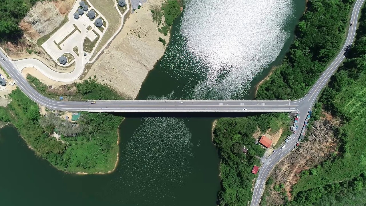
 Click to Access the Navigation Map GPS
 Art, Culture and Heritage
 Landmarks and Memorials(1)
 Art, Craft Centres, Tradition(2)
 Museums(2)
 Educational Places
 Educational Gardens, Farm(1)
 Places of Worship
 Temple(6)
 Mosque(2)
 Other Sacred Sites(3)
 Suburban Living
 Village, Community(4)
 National Parks and Marine Reserves(2)
 Mountain (Doi)(5)
Dam, Reservoir, Lake(5)
Mountain (Doi)(5)
Dam, Reservoir, Lake(5)
 Waterfalls(13)
 Hot Springs(2)
 Caves(7)
 River, Canal(4)
 Islands(1)
 Other natural attractions(8)
 Entertainment and Agricultural
 Stadium(1)
 Farms, Parks and Ecotourism(4)
 Outdoor and Adventure Activities(1)
 Travel Articles, Recipes
 Travel Review, Food Review(2)


