
lovethailand home >South Travel Attractions >Yala Travel Attractions >Than To >Ban Rae > Sakai Waterfall
TL;DR: Sakai Waterfall is located at Moo 3, Ban Sakai, Ban Hae Subdistrict, Than To District, Yala Province, open Daily, hours 24 Hours.

Sakai Waterfall
Open Days: Daily
Opening Hours: 24 Hours
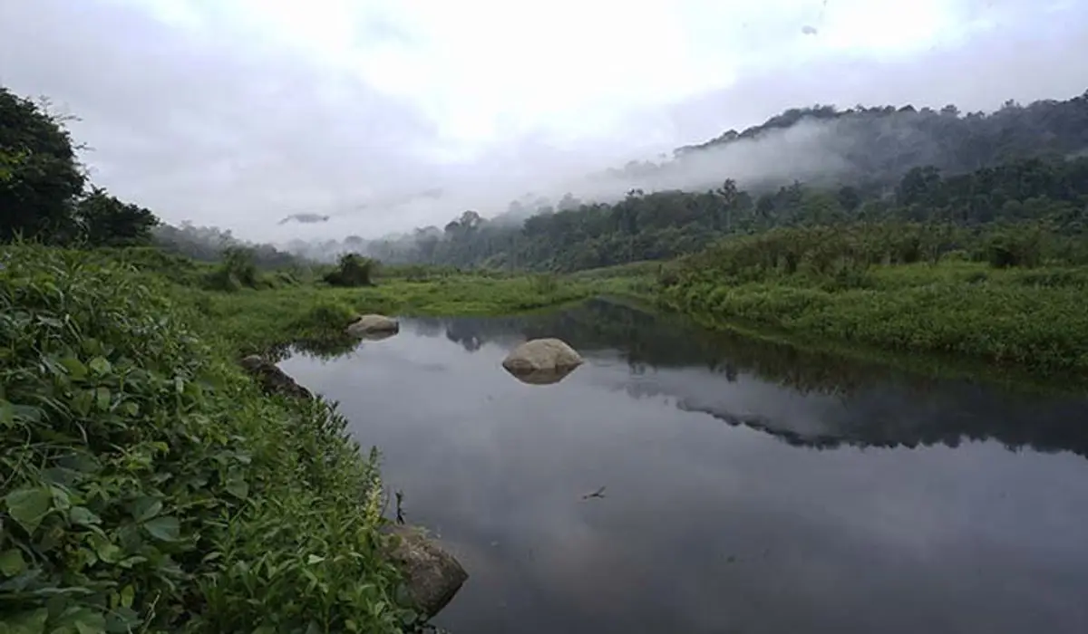
Sakai Waterfall in Yala Province is a small natural waterfall located in Moo 3, Ban Sakai, Ban Hae Subdistrict, Than To District. It is closely connected with the Sakai Ban Hae community, an old ethnic community area with cultural significance in Yala. The waterfall is best understood as a small community-based nature site rather than a large developed waterfall. It offers a stream, forested surroundings, natural pools in safe sections, and a chance to understand the Ban Sakai area respectfully. Travelers use Highway 410 on the Yala – Betong route, then turn from the main road into Ban Sakai for about 4 km. Daytime visits and advance local coordination are strongly recommended.
Sakai Waterfall is a small natural waterfall in Ban Sakai, Moo 3, Ban Hae Subdistrict, Than To District, Yala Province. Unlike large national-park waterfalls with clear visitor facilities, Sakai Waterfall is more closely tied to a local community landscape. It is part of a mountain-stream environment where water, forest, village life, and local cultural identity meet in one place. The waterfall is suitable for travelers who want a quiet natural stop and a respectful community-based travel experience.
The waterfall is not known for dramatic height or large cascades. Its value lies in its calm, local character. Visitors come for the stream, shaded surroundings, natural pools, and the setting of Ban Sakai. This makes the site different from Than To Waterfall or La-ong Rung Waterfall, which are better known as larger waterfall attractions in the Bang Lang National Park area. Sakai Waterfall is more intimate and should be visited with slower expectations.
Ban Sakai is located about 80 km from Yala city on the route toward Betong. From the main highway, visitors turn into a local road that continues about 4 km into the mountainous community area. The destination is associated with Sakai Ban Hae, a community recorded as an old community area and an ethnic-cultural site in Yala Province. Because the site is both a natural attraction and a lived-in community, visitors should travel with sensitivity and avoid treating local residents as a tourist display.
The community is historically associated with the Sakai or Ngo Pa people, and in broader contemporary discussions this context is often connected with the Mani ethnic group of southern Thailand. Public cultural sources describe the community as having a close relationship with forest life, local materials, medicinal plants, bamboo tools, streams, and upland settlement patterns. Over time, the community has changed through settlement development, schooling, agriculture, and closer contact with outside society.
The surname “Sri Than To” is an important cultural marker linked with the Ban Sakai community. Cultural records state that it was royally granted by Princess Srinagarindra, the Princess Mother. This gives Ban Sakai a meaningful place in the social history of Than To District and helps explain why the area is often described not only as a village but also as a cultural learning destination.
Sakai Waterfall should therefore be presented as both a natural and cultural destination. Visitors may enjoy the stream, forest, and waterfall setting, but they should also respect the community. Do not enter private areas without permission, do not photograph people or homes without asking, and do not expect residents to perform or demonstrate their culture for visitors. Good travel behavior protects the dignity of the host community and makes tourism more sustainable.
The waterfall itself is small, with a stream and natural water areas suitable for careful relaxation. Water levels may change by season. During the rainy period, the stream may become livelier but also more slippery and potentially stronger. During drier periods, access may be easier, but water volume may vary. Travelers should check weather conditions and ask local contacts before entering the area, especially when traveling with children or older visitors.
Than To District is largely mountainous, with complex hill terrain and an average elevation of roughly 300 to 500 meters above sea level in many areas. Some peaks rise above 1,000 meters. This geography explains why the district has many streams, forested slopes, and water-related attractions. It also means that village roads and natural paths can be affected by rain, erosion, and limited visibility during late hours.
Although public travel listings show Sakai Waterfall as open daily and 24 hours, the most practical and safest time to visit is daytime, especially from morning to early afternoon. The area is a community and mountain-stream setting, not a brightly lit urban attraction. Travelers should avoid visiting after dark, during heavy rain, or when local contacts advise against entering the area.
Getting to Sakai Waterfall follows the route to Ban Sakai. From Yala city, take Highway 410, the Yala – Betong route, toward Than To and Ban Hae. Around Km.67 – Km.68, turn from the main road into Ban Sakai for about 4 km. The final section is a local mountain road. A private car, rental vehicle, or local hired transport is recommended. If travelers are unfamiliar with the area, they should coordinate with Ban Hae Subdistrict Administrative Organization or local residents before traveling.
For visitors starting from Betong, follow Highway 410 toward Than To and Yala, then watch for the Ban Hae and Ban Sakai access area. The route can be combined with La-ong Rung Waterfall, Chaloem Phra Kiat Rama IX Waterfall, Aiyoeweng Sea of Mist, Than To Waterfall, and Bang Lang Dam depending on the direction of travel. Because this is a mountain-road corridor, time planning is important.
The visitor experience at Sakai Waterfall is simple and quiet. Travelers can rest by the stream, enjoy the sound of water, take nature photographs, and learn about the local environment. The site is not suited to hurried mass tourism. It is better for slow travelers, nature-oriented visitors, cultural learners, and people who can behave respectfully in a community setting.
The best time to visit is from morning to early afternoon. This gives visitors enough daylight for the local road, streamside walking, and returning to the main road safely. During rainy months, the forest and stream may look fresher, but the risk of slippery surfaces and stronger flow increases. During drier months, the visit is generally easier, though the waterfall’s water level may be lower.
Water play should be limited to safe, shallow, calm sections. Natural streams can be unpredictable even when the waterfall is small. Children must be supervised at all times. Visitors should avoid jumping from rocks, climbing wet boulders, or entering the water during heavy rain. If the water becomes muddy or the current becomes stronger, visitors should leave the stream immediately.
Photography should focus on nature and place rather than people. Good subjects include the stream, natural pools, rocks, forest shade, village paths, and the surrounding mountain atmosphere. If visitors want to photograph residents, homes, or community activities, they should ask permission first. This is especially important in ethnic community areas where privacy and dignity should be protected.
Useful items include non-slip footwear, a change of clothes, towel, waterproof phone pouch, drinking water, personal medicine, a trash bag, and some cash for local spending. Services near the waterfall may be limited, so travelers should prepare before entering the village road. Mobile signal may also vary in mountain areas.
Visitors should avoid loud noise, littering, entering homes or private land, photographing people without permission, asking insensitive questions, and leaving food waste near the stream. Because Sakai Waterfall is a small site, even a small amount of trash can damage the experience and affect local water quality.
Sakai Waterfall works best as part of a Than To and Ban Hae route. Nearby places to combine include Ban Sakai, La-ong Rung Waterfall, Than To Waterfall, Bang Lang National Park, Bang Lang Dam, Than To Lake, and the Aiyoeweng – Betong route. This makes the trip more worthwhile because Sakai Waterfall itself is a compact destination.
Food planning should be done before entering the waterfall area. Restaurants and cafés are more likely to be found around Ban Hae, Than To, and Bang Lang Dam than directly beside the waterfall. Travelers should choose meal stops according to travel direction and avoid expecting full tourist services at the waterfall site.
Accommodation depends on the wider itinerary. Travelers who want to explore Than To can stay around Than To or Mae Wat. Those continuing toward Bang Lang Dam may choose accommodation near the reservoir. Travelers who want more restaurants and city services can stay in Yala city or Betong town and use Sakai Waterfall as a route stop.
Getting There from Yala city: take Highway 410 toward Than To and Betong for about 80 km. Around Km.67 – Km.68, turn into Ban Sakai for about 4 km. The waterfall is in the Ban Sakai community area, Moo 3, Ban Hae Subdistrict, Than To District. Use a private car, rental car, or local hired transport, and check road conditions with local contacts before entering the community route.
Overall, Sakai Waterfall is a small but meaningful natural destination in Yala Province. Its value comes from the combination of stream, forest, village landscape, and the cultural identity of Ban Sakai. It is best for respectful travelers who want a quiet nature stop and a deeper understanding of the Than To – Ban Hae area. With careful travel, community respect, and responsible waste management, Sakai Waterfall can remain a modest but valuable stop on the Yala – Betong route.
| Name | Sakai Waterfall |
| Location | Moo 3, Ban Sakai, Ban Hae Subdistrict, Than To District, Yala Province |
| Address | Ban Sakai area, Moo 3, Ban Hae Subdistrict, Than To District, Yala 95150, Thailand |
| Reference Coordinates For Sakai Ban Hae Area | Latitude 6.1057712322, Longitude 101.159512921 |
| Highlights | Small community waterfall, natural stream, forested setting, shallow water areas in safe sections, and cultural context of Sakai Ban Hae community |
| Distinctive Features | Small waterfall in the mountain landscape of Than To District, suitable for quiet nature stops and respectful community-based travel |
| Importance | Connected with stream ecology, forested hills, and the ethnic-cultural significance of the Sakai Ban Hae old community area |
| History / Area Context | Ban Sakai is a community in Moo 3, Ban Hae Subdistrict, about 4 km from the main road into the mountains, and is promoted as a cultural learning area together with its natural setting |
| Name Origin | Named after Ban Sakai and the Sakai Ban Hae community where the waterfall and cultural learning area are located |
| Travel Information | From Yala city, take Highway 410 on the Yala – Betong route for about 80 km, then turn from the main road around Km.67 – Km.68 into Ban Sakai for about 4 km |
| Current Status | Open as a small community nature attraction and cultural learning area. Visitors should coordinate with local authorities or residents before traveling |
| Open Days | Daily |
| Opening Hours | 24 Hours |
| Best Time To Visit | Daytime, especially morning to early afternoon, for safer access and water activities |
| Facilities | Natural stream area, pools, community rest points, and basic local services in Ban Sakai or areas designated by the community |
| Main Areas / Zones | Sakai Waterfall, stream area, natural pools, forested hill setting, Ban Sakai village, and Sakai Ban Hae cultural learning area |
| Caretaker / Coordinating Agency | Ban Hae Subdistrict Administrative Organization, Than To District, Yala Province, and Ban Sakai community |
| Main Contact Number | Ban Hae Subdistrict Administrative Organization Tel. 073-373-445 |
| Website / Information Sources | Ban Hae Subdistrict Administrative Organization, LoveThailand.org, Ministry of Culture cultural database, Cultural Environment database, and Thailand Cultural Encyclopedia |
| Nearby Tourist Attractions | 1. Ban Sakai, about 0 km 2. La-ong Rung Waterfall, about 10 km 3. Than To Waterfall, Bang Lang National Park, about 25 km 4. Bang Lang National Park, about 25 km 5. Bang Lang Dam and Than To Lake, about 35 km 6. Aiyoeweng Sea of Mist and Skywalk, about 40 km |
| Nearby Restaurants | 1. Krua Ka Areesah, Ban Hae, about 8 km, Tel. 080-601-2609 2. Sila Café, Ban Hae, about 8 km, Tel. 065-024-9454 3. Sila, Buloh Saniae, about 10 km, Tel. 089-974-6373 4. Café Amazon, Than To Self-Help Settlement Station, about 20 km, Tel. 095-967-3154 5. Ruen Balae Restaurant, Bang Lang Dam, about 35 km, Tel. 073-281-128 6. Krua Muslim Restaurant, Bang Lang Dam, about 35 km, Tel. 093-606-0667, 084-890-7341 |
| Nearby Accommodations | 1. Resort Ban Saitan 21, about 30 km, Tel. 084-660-1380 2. Khun Saichol Villa, Bang Lang Dam, about 35 km, Tel. 073-281-129 3. Cool Camping Resort, about 40 km, Tel. 073-373-224, 081-897-5207, 084-313-7297 4. Aiyoeweng Land, about 40 km, Tel. 095-350-2595, 084-968-6622 5. Grand Mandarin Betong Hotel, about 70 km, Tel. 077-323-333, 073-235-777 6. Garden View Betong Hotel, about 70 km, Tel. 073-235881-4, 086-488-7190 |
Frequently Asked Questions (FAQ)
Q: Where is Sakai Waterfall located?
A: Sakai Waterfall is located in Moo 3, Ban Sakai, Ban Hae Subdistrict, Than To District, Yala Province. It is a small waterfall in the Sakai Ban Hae community area.
Q: What are the opening hours of Sakai Waterfall?
A: Public travel information lists Sakai Waterfall as open daily, 24 hours. However, daytime visits, especially from morning to early afternoon, are recommended for safer access and water activities.
Q: Can visitors swim at Sakai Waterfall?
A: Water play is possible only in safe, shallow, calm areas. Visitors should watch for slippery rocks, changing water levels after rain, and strong current. Children must be supervised closely.
Q: Who is Sakai Waterfall suitable for?
A: It is suitable for travelers who want a quiet small nature stop, stream scenery, forested surroundings, and a respectful cultural-learning visit in the Ban Sakai community area.
Q: How do travelers get to Sakai Waterfall?
A: From Yala city, take Highway 410 on the Yala – Betong route for about 80 km. Around Km.67 – Km.68, turn into Ban Sakai for about 4 km.
Q: Should visitors contact anyone before traveling?
A: Yes. Visitors should contact Ban Hae Subdistrict Administrative Organization or local residents before entering the area to confirm road conditions, access suitability, and community guidance.
Q: What should visitors be careful about?
A: Visitors should be careful with mountain access roads, slippery rocks, stronger flow after rain, and community privacy. Do not photograph people or homes without permission.
Q: What nearby attractions can be combined with Sakai Waterfall?
A: Good nearby options include Ban Sakai, La-ong Rung Waterfall, Than To Waterfall, Bang Lang National Park, Bang Lang Dam, Than To Lake, and the Aiyoeweng – Betong route.
 Category: ●Nature and Wildlife
 Group: ●Waterfalls
Last Update : 2 WeekAgo
 Last Update : 2 WeekAgo
 Click to Access the Navigation Map GPS
 Art, Culture and Heritage
 Landmarks and Memorials(1)
 Art, Craft Centres, Tradition(2)
 Museums(2)
 Educational Places
 Educational Gardens, Farm(1)
 Places of Worship
 Temple(6)
 Mosque(2)
 Other Sacred Sites(3)
 Suburban Living
 Village, Community(4)
 National Parks and Marine Reserves(2)
 Mountain (Doi)(5)
 Dam, Reservoir, Lake(5)
Waterfalls(13)
Dam, Reservoir, Lake(5)
Waterfalls(13)
 Hot Springs(2)
 Caves(7)
 River, Canal(4)
 Islands(1)
 Other natural attractions(8)
 Entertainment and Agricultural
 Stadium(1)
 Farms, Parks and Ecotourism(4)
 Outdoor and Adventure Activities(1)
 Travel Articles, Recipes
 Travel Review, Food Review(2)


