
lovethailand home >South Travel Attractions >Yala Travel Attractions >Ban Nang Sata >Taling Chan > Khao Pok Yo
TL;DR: Khao Pok Yo is located at Moo 6, Ban Talat Nikhom, Taling Chan Subdistrict, Bannang Sata District, Yala Province, Thailand, open Daily, hours Accessible throughout the day depending on road and safety conditions; early.

Khao Pok Yo
Open Days: Daily
Opening Hours: Accessible throughout the day depending on road and safety conditions; early morning to mid-morning is the best time for the sea of mist
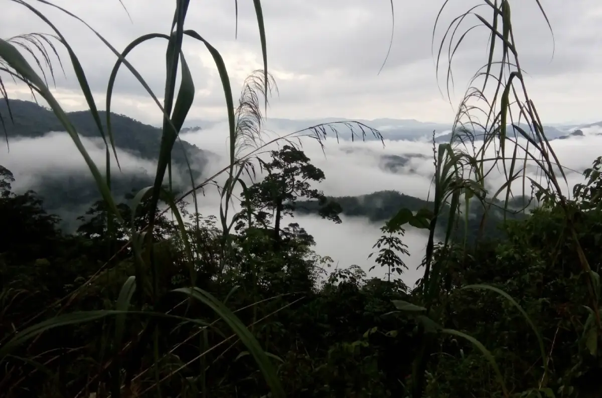
Khao Pok Yo, also written in Thai travel sources as Khao Pokyo, is one of the most distinctive mountain viewpoints in Bannang Sata District, Yala Province. It is located at Moo 6, Ban Talat Nikhom, Taling Chan Subdistrict, within the area of the Southern Self-Help Settlement in Yala. Rising to about 1,095 - 1,096 meters above sea level, Khao Pok Yo is widely described as the highest mountain range among Thailand’s 5 southern border provinces. The summit area is known for cool air, wide mountain scenery, a view over Yala’s highland landscape, and a morning sea of mist that spreads across the valleys on suitable days.
The value of Khao Pok Yo comes not only from its elevation but also from its position close to the Yala-Betong route. Travelers using Highway 410 can connect the mountain with Ban Talat Nikhom, Nikhom Kuelong, Sukthalai Waterfall, Bang Lang Dam, Than To, and Betong without leaving the main travel corridor of Yala Province. This makes Khao Pok Yo an excellent addition for travelers who want a mountain viewpoint, misty sunrise, waterfall scenery, and rural highland communities in one route.
Taling Chan Subdistrict in Bannang Sata is a mountainous area with complex ridges, steep slopes, valleys, agricultural land, and the Pattani River flowing along the western side. Highway 410 passes through the subdistrict from north to south. This landscape explains why Khao Pok Yo is more than a scenic lookout. It is part of a highland system connected with communities, orchards, forested slopes, communication infrastructure, and the geography of Yala’s southern border region.
The best time to visit Khao Pok Yo is before sunrise through early morning. On humid days, especially after rain, mist rises from the valleys and spreads across the lower landscape. From the summit, the ridges appear like islands above a white cloud sea. Some mornings have thick mist, while others reveal a clear panorama of mountains and villages after the mist lifts. This variation is part of the attraction because every morning gives a different atmosphere.
The summit of Khao Pok Yo also has a practical role. It is associated with radio, television, and official communication systems. In the past, the mountain hosted relay stations for several television channels. As broadcasting systems changed to digital networks, some older functions changed, and parts of the summit area became relevant to local discussions about nature tourism, overnight viewing, and morning sea-of-mist travel. This combination of communication infrastructure and mountain scenery gives the site a character that is different from ordinary viewpoints.
The access road is important to both local residents and visitors. It links Ban Talat Nikhom, farms, orchards, forested slopes, and the summit area. Earlier reports described the route as difficult and suitable mainly for 4-wheel-drive vehicles with experienced drivers because of steep terrain. Later, road improvement and community clean-up activities helped make the route more orderly and safer. Even so, visitors should still drive carefully because mountain roads can become slippery after rain and may be affected by landslides during periods of heavy rainfall.
Khao Pok Yo remains an active local nature site. Taling Chan Subdistrict Administrative Organization lists Khao Pok Yo as a natural resource of the subdistrict, and in 2025 local military, community leaders, and residents carried out landscape improvement along the road to Khao Pok Yo at Ban Talat Nikhom. This confirms that the route remains relevant to local use and nature tourism, with ongoing community and agency attention.
Visitors should treat Khao Pok Yo as a community mountain viewpoint, not a fully commercial tourist complex. Advance coordination is recommended, especially for pre-dawn travel, group visits, overnight stays, or camping. The area is connected with the Southern Self-Help Settlement, Taling Chan Subdistrict Administrative Organization, Ban Talat Nikhom community, and communication facilities on the summit. Contacting local agencies before travel helps ensure a safer and more respectful visit.
The scenic highlight is the wide view over Yala and the surrounding southern border mountains. On clear days, some viewpoints allow visitors to see the mountain lines of Yala, Pattani, and Narathiwat, and certain angles have been reported to offer distant views toward Pattani Bay. This makes Khao Pok Yo especially interesting for travelers who want to understand the physical geography of the far south, where mountains, river valleys, communities, and provincial landscapes connect.
The climate on the summit is cooler than the lowland areas of Yala and Bannang Sata. Early morning air can feel noticeably cold, especially after rain or during humid periods with light wind. Visitors should bring a light jacket or outer layer even though the destination is in southern Thailand. The cool air is one of the reasons local travelers enjoy staying or arriving early to wait for the morning mist.
The main activities at Khao Pok Yo are watching the sea of mist, seeing sunrise, photographing mountain scenery, enjoying cool highland air, and camping only in approved areas. The experience should not be rushed. The appeal of the mountain lies in waiting for light, mist, wind, and weather to create the view. Some mornings bring dense fog, others bring layered mountains and clear skies; both create a strong sense of place.
For photographers, the best plan is to arrive before dawn. The strongest photo window is from shortly before sunrise until around 08.00, when mist, light, and mountain layers change quickly. Wide-angle lenses work well for the full sea-of-mist scene, while medium or telephoto lenses are useful for isolating ridges, villages, and mist trails moving through the valleys. A cloth for wiping lenses is useful because humidity can be high.
Khao Pok Yo is closely connected with Sukthalai Waterfall, also known as Kuelong Waterfall. The waterfall is located within the Southern Self-Help Settlement on Khao Pok Yo in Taling Chan Subdistrict. It was discovered in 1964 and was graciously named “Sukthalai Waterfall” by Princess Srinagarindra, the Princess Mother. The waterfall has 5 tiers, is surrounded by fertile forest, and has pools where visitors can rest and enjoy the water. Combining Khao Pok Yo with Sukthalai Waterfall gives travelers both mountain mist and forest-waterfall scenery in one trip.
Ban Talat Nikhom and Nikhom Kuelong are also linked with Sukthalai Palace, an important memorial site associated with royal visits and the history of local community development. Sukthalai Palace, Sukthalai Waterfall, and Khao Pok Yo form a meaningful cluster of places that present nature, community history, and local memory together. This makes the area more complete than a single viewpoint stop.
Another nearby place worth combining with the route is Yi La Pan Bridge, a historical bridge over the Pattani River on the Yala-Betong route. The bridge is connected with earlier transportation, local trade, and the movement of people between Yala, Betong, and the lower peninsula. Adding Yi La Pan Bridge to the itinerary gives the journey a local historical dimension.
Bang Lang Dam is another major attraction that fits well with a Khao Pok Yo route. The dam is a large multipurpose hydroelectric project on the Pattani River and is one of Yala’s most important water landscapes. Its reservoir, mountain views, and boat routes toward the Hala forest area make it a strong complement to the mountain scenery of Khao Pok Yo.
Bang Lang National Park and Than To Waterfall can also be included in a 2-day Yala nature itinerary. The park covers parts of Bannang Sata, Than To, and Betong districts and contains rainforest, watershed areas, waterfalls, and rare wildlife habitat. Travelers who want a deeper nature experience can combine Khao Pok Yo, Sukthalai Waterfall, Bang Lang Dam, and Than To Waterfall in one route.
Getting there from Yala city is most practical by private car or a locally arranged vehicle. Take Highway 410 on the Yala-Betong route toward Bannang Sata. After about 40 km from Yala city, turn into the Ban Talat Nikhom / Nikhom Kuelong area for about 8 km, then continue uphill for about 7 km to the summit area. The mountain section is steep and should be driven with a suitable vehicle and an experienced driver.
Travelers coming from Betong can use Highway 410 northward through Than To and Bannang Sata, then turn into the Nikhom Kuelong route according to local signs or local guidance. This works well as part of a Betong-Than To-Bannang Sata-Yala route. Allow more travel time than a normal lowland road because Highway 410 includes curves, hills, rain-prone sections, and occasional mist.
Travelers without private transport should arrange a local vehicle from Yala city or Bannang Sata town. It is advisable to contact the Southern Self-Help Settlement in Yala or Taling Chan Subdistrict Administrative Organization before the trip. Going up the mountain with an unfamiliar driver is not ideal in pre-dawn darkness, fog, or after heavy rain.
A half-day visit can start before dawn from Yala city, reach Khao Pok Yo for sunrise and the sea of mist, then continue to Sukthalai Waterfall or Sukthalai Palace before returning to Yala around midday or afternoon. This plan suits travelers who want the main highlights without staying overnight, but it requires an early start and good road conditions.
A full-day route can begin with the sea of mist at Khao Pok Yo, then continue to Sukthalai Waterfall, Yi La Pan Bridge, and Bang Lang Dam. This gives travelers a varied route of misty mountain scenery, forest waterfall, local history, and reservoir landscape. For photographers, it provides several visual moods in one day: sunrise mist, forest water, historical structures, and mountain-water scenery.
A 2-day and 1-night trip gives more flexibility. Travelers can stay in Yala city, Bannang Sata, or near Bang Lang Dam. One day can be used for Bang Lang Dam, Yi La Pan Bridge, and Sukthalai Waterfall, while the following morning can be reserved for Khao Pok Yo’s mist. This reduces rushing and improves the chance of catching good weather.
Weather is the most important safety factor. Taling Chan experiences a humid climate with rainy and hot seasons, and heavy rain is common around October to December. The mountain route has previously been affected by landslides during heavy rain. Visitors should check road and weather conditions, drive slowly, avoid stopping in risky slope areas, and avoid the summit route during heavy rain, thick fog, or very low visibility.
Camping is possible only in approved areas and must be coordinated with local officials or site caretakers. Visitors should not camp near cliffs, unstable slopes, communication facilities, or official buildings. Those staying overnight should bring rain protection, lighting, warm clothing, drinking water, food, trash bags, and personal medicine. All trash must be taken back down.
Responsible travel is essential. Do not litter, play loud music, light fires outside approved areas, enter communication or government facility zones, drive off suitable routes, damage plants, or disturb residents of Ban Talat Nikhom. Khao Pok Yo is a mountain, a community landscape, an agricultural area, and a communication-site area, not a private tourist playground. Respect for local rules keeps the place usable for everyone.
Facilities on Khao Pok Yo are limited compared with major developed attractions. Visitors should prepare drinking water, snacks, flashlight, power bank, raincoat, waterproof bag, suitable footwear, and personal items. Main meals are better planned in Bannang Sata town, Yala city, or roadside restaurants before or after the mountain visit.
Restaurants near the route are mainly in Bannang Sata town and along Highway 410. Options include riverside cafés, Korean-style food, hotpot, tea shops, local cafés, and small roadside restaurants. Groups should call ahead to confirm opening hours and food availability, especially on weekdays or when traveling with many people.
Accommodation directly on the mountain is limited. Most visitors use Yala city, Bannang Sata, or Bang Lang Dam as a base. Travelers who want nature can stay around Bang Lang Dam or the Than To route, while those who prefer urban convenience can stay in Yala city and depart before dawn. The best base depends on the purpose of the trip: Bannang Sata or Bang Lang for mist and nature, Yala city for services and easier accommodation choices.
Khao Pok Yo is suitable for nature lovers, landscape photographers, travelers interested in geography, and visitors who want to see a southern Thai sea of mist without traveling to northern Thailand. It also works well for educational groups because it shows the relationship between mountain terrain, forest, self-help settlement land, local agriculture, road access, and communication infrastructure.
Families can visit, but they should choose a dry-road day with good visibility. Children should be supervised closely, especially near slopes or viewpoint edges. Elderly travelers should avoid slippery areas and should bring warm clothing, drinking water, and personal medicine. Safety should be prioritized over reaching the summit at any cost.
Khao Pok Yo expands the travel image of Yala. Many travelers know the province through Betong, Aiyerweng Skywalk, Bang Lang Dam, or Yala city, but Khao Pok Yo offers another layer: a high mountain viewpoint near the Yala-Betong route, with cool air and mist rising from the valleys. Its beauty is not built around large structures, but around silence, altitude, weather, and the scale of the southern border landscape.
From a sustainable tourism perspective, Khao Pok Yo should be developed carefully. The road, forest, community land, and safety conditions must be protected while visitors are allowed to enjoy the view. Local road maintenance and landscape-cleaning activities are positive steps, but visitors also carry responsibility. Good travel here means leaving no trash, respecting local people, and using the mountain lightly.
In summary, Khao Pok Yo in Yala Province is a high mountain viewpoint and sea-of-mist destination in Bannang Sata District. With an elevation of about 1,096 meters, cool air, a wide morning panorama, links to Sukthalai Waterfall and Sukthalai Palace, and access from the Yala-Betong route, it is ideal for travelers seeking a quieter and deeper nature experience in Thailand’s far south. The best visit begins with preparation: check weather, use a suitable vehicle, contact local agencies, drive carefully, and give enough time to enjoy the mist, light, mountains, and calm atmosphere of Bannang Sata.
| Name | Khao Pok Yo |
| Related Names | Khao Pokyo / Khao Pok Yo Summit / Khao Pok Yo Sea Of Mist Viewpoint |
| Location | Moo 6, Ban Talat Nikhom, Taling Chan Subdistrict, Bannang Sata District, Yala Province, Thailand |
| Address | Southern Self-Help Settlement Area, Moo 6, Taling Chan Subdistrict, Bannang Sata District, Yala Province 95130, Thailand |
| Reference Coordinates | 6.333056, 101.391111 |
| Elevation | About 1,095 - 1,096 Meters Above Sea Level |
| Highlights | High Mountain Viewpoint In The Southern Border Provinces, Cool Air, Morning Sea Of Mist, Sunrise, Yala Highland Views, And Layered Mountain Scenery |
| Distinctive Features | High Mountain In The Southern Self-Help Settlement Area With Forested Slopes, Orchards, Summit Viewpoint, And Communication Facilities |
| Suitable Activities | Sea Of Mist Viewing, Sunrise, Landscape Photography, Cool-Air Resting, Yala Geography Viewing, And Camping In Approved Areas |
| Main Areas / Zones | Mountain Access Road, Ban Talat Nikhom, Sea-Of-Mist Viewpoint, Summit Area, Communication Facilities, Approved Camping Areas, Sukthalai Waterfall, And Sukthalai Palace |
| Travel Information | From Yala City, Take Highway 410 On The Yala-Betong Route For About 40 Km, Turn Into Ban Talat Nikhom / Nikhom Kuelong For About 8 Km, Then Continue Uphill About 7 Km To The Summit Area. A Suitable Vehicle And Experienced Driver Are Recommended |
| Current Status | A Local Nature Attraction And Sea-Of-Mist Viewpoint In Taling Chan Subdistrict, With Road And Landscape Maintenance By Local Agencies And Community Members |
| Open Days | Daily |
| Opening Hours | Accessible Throughout The Day Depending On Road And Safety Conditions; Early Morning To Mid-Morning Is Best For Mist Viewing |
| Fees | No Official Ticketing System Is Listed. Other Costs Such As Local Transport, Approved Camping, Or Community Services Should Be Confirmed With Local Contacts Before Travel |
| Best Time To Visit | Before Sunrise To Around 08.00 For Sea Of Mist And Morning Light, Especially On Humid Mornings After Rain |
| Safety Notes | The Mountain Road Is Steep And Can Be Slippery After Rain. Check Weather And Road Conditions, Drive Slowly, And Avoid Low-Visibility Conditions |
| Facilities | Community Mountain Viewpoint With Limited Facilities. Visitors Should Bring Drinking Water, Snacks, Flashlight, Rain Protection, Trash Bags, And Personal Supplies |
| Management / Local Contact | Southern Self-Help Settlement, Yala Province, And Taling Chan Subdistrict Administrative Organization |
| Main Contact Number | Southern Self-Help Settlement, Yala Province Tel. 073-261-512 Taling Chan Subdistrict Administrative Organization Tel. 073-282-249 |
| Nearby Tourist Attractions | 1. Sukthalai Waterfall / Kuelong Waterfall, About 7 - 10 Km From The Summit Or About 1 Km From Ban Talat Nikhom 2. Sukthalai Palace, About 7 - 10 Km From The Summit 3. Yi La Pan Bridge, About 15 - 20 Km 4. Krachaeng Cave, About 20 - 25 Km 5. Bang Lang Dam, About 30 - 35 Km 6. Bang Lang National Park / Than To Waterfall, About 30 - 35 Km 7. Sakai Village, Ban Rae Subdistrict, About 40 - 45 Km |
| Nearby Restaurants | 1. Riverside Bannang Sata, About 15 - 20 Km, Tel. 088-395-1135 2. Ajumma Bannang Sata, About 15 - 20 Km, Tel. 065-404-0064 3. Sep Thang Mala Bannang Sata, About 15 - 20 Km, Tel. 064-013-7095 4. Mochi Cha Bannang Sata, About 15 - 20 Km, Tel. 088-762-8097 5. The Apple Yam, Tano Pute, About 20 - 25 Km, Tel. 093-459-4332 |
| Nearby Accommodations | 1. Bang Lang Dam Guesthouse, About 30 - 35 Km, Tel. 073-281-063 Ext. 2001 2. Khun Sai Chon Villa, Bang Lang Dam, About 30 - 35 Km 3. Avalynn Resort Than To, About 45 - 50 Km 4. 66 Baanaisuan Than To, About 55 - 60 Km 5. Yala Grand Palace Hotel, About 45 - 50 Km, Tel. 073-215-711, 073-215-712 6. Park View Hotel Yala, About 45 - 50 Km, Tel. 073-217-001 |
Frequently Asked Questions (FAQ)
Q: Where Is Khao Pok Yo Located?
A: Khao Pok Yo is located at Moo 6, Ban Talat Nikhom, Taling Chan Subdistrict, Bannang Sata District, Yala Province, within the Southern Self-Help Settlement area.
Q: How High Is Khao Pok Yo?
A: Khao Pok Yo is about 1,095 - 1,096 meters above sea level and is widely described as the highest mountain range among Thailand’s 5 southern border provinces.
Q: When Is The Best Time To See The Sea Of Mist?
A: The best time is before sunrise to around 08.00, especially on humid mornings or after rain, when mist is more likely to fill the valleys.
Q: How Do Travelers Get To Khao Pok Yo?
A: From Yala city, take Highway 410 toward Bannang Sata for about 40 km, turn into Ban Talat Nikhom / Nikhom Kuelong for about 8 km, then continue uphill for about 7 km to the summit area.
Q: Is There An Entrance Fee?
A: No official ticketing system is listed. Other costs such as local transport, approved camping, or community services should be confirmed with local contacts before travel.
Q: Can Visitors Camp At Khao Pok Yo?
A: Camping is possible only in approved areas. Visitors who want to stay overnight should contact local authorities or site caretakers before traveling.
Q: Which Nearby Places Can Be Combined With Khao Pok Yo?
A: Nearby places include Sukthalai Waterfall, Sukthalai Palace, Yi La Pan Bridge, Krachaeng Cave, Bang Lang Dam, Bang Lang National Park, Than To Waterfall, and Sakai Village.
Q: What Should Visitors Prepare Before Going?
A: Visitors should check weather and road conditions, use a suitable vehicle, bring drinking water, rain protection, flashlight, good-grip shoes, and contact local agencies before pre-dawn travel or camping.
 Category: ●Nature and Wildlife
 Group: ●Mountain (Doi)
Last Update : 2 WeekAgo
 Last Update : 2 WeekAgo
 Click to Access the Navigation Map GPS
 Art, Culture and Heritage
 Landmarks and Memorials(1)
 Art, Craft Centres, Tradition(2)
 Museums(2)
 Educational Places
 Educational Gardens, Farm(1)
 Places of Worship
 Temple(6)
 Mosque(2)
 Other Sacred Sites(3)
 Suburban Living
 Village, Community(4)
 National Parks and Marine Reserves(2)
Mountain (Doi)(5)
National Parks and Marine Reserves(2)
Mountain (Doi)(5)
 Dam, Reservoir, Lake(5)
 Waterfalls(13)
 Hot Springs(2)
 Caves(7)
 River, Canal(4)
 Islands(1)
 Other natural attractions(8)
 Entertainment and Agricultural
 Stadium(1)
 Farms, Parks and Ecotourism(4)
 Outdoor and Adventure Activities(1)
 Travel Articles, Recipes
 Travel Review, Food Review(2)


