
lovethailand home >South Travel Attractions >Yala Travel Attractions >Be Tong >Ai Yoe Weng > Toh Mo Waterfall
TL;DR: Toh Mo Waterfall, Yala attractions : Nature and Wildlife, Waterfalls.

Toh Mo Waterfall
Open Days: Access must be arranged in advance with Bang Lang National Park and a local guide
Opening Hours: Entry depends on park permission, guide arrangement, weather, and route conditions on the travel date
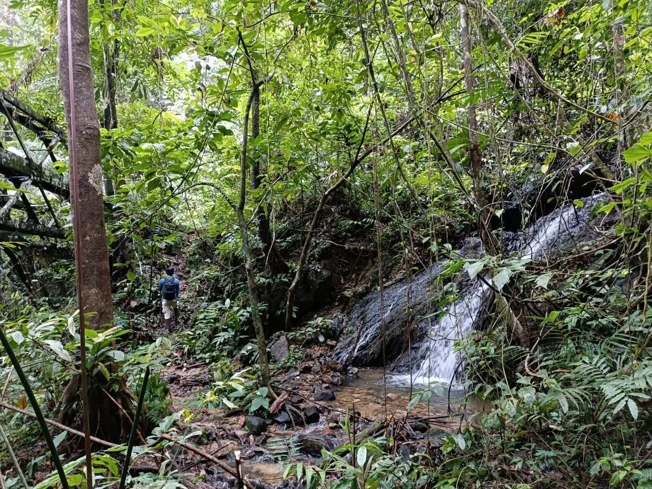
To Mo Waterfall, also found in some Thai sources as Kato Mo Waterfall or Khlong To Mo Waterfall, is a remote natural waterfall in the Hala-Bala forest landscape of Yala Province. It lies around the boundary area between Aiyoeweng Subdistrict in Betong District and Mae Wat Subdistrict in Than To District. The waterfall is linked with Bang Lang National Park and Bang Lang National Park Protection Unit BL.2 To Mo. Access is not designed for casual independent travel. Visitors normally need to coordinate with park staff, local guides, and transport providers, using either a boat route from Bang Lang Dam or the Ban Santi route.
To Mo Waterfall is one of Yala’s more remote and conservation-oriented natural attractions. Unlike waterfalls located close to highways or developed picnic areas, To Mo Waterfall sits deep within the Hala-Bala rainforest landscape. The area is connected with mountains, headwater streams, Bang Lang reservoir, Khlong To Mo, Khlong Hala, and the wider ecosystem of Bang Lang National Park. Its appeal lies in its natural condition, forest atmosphere, ecological value, and the sense of entering one of the most intact rainforest landscapes in southern Thailand.
The waterfall is associated with the boundary zone between Betong and Than To districts, particularly Aiyoeweng Subdistrict and Mae Wat Subdistrict. It is also linked with Bang Lang National Park Protection Unit BL.2 To Mo and the forested watershed around Khlong To Mo. Because of this setting, To Mo Waterfall is not a place visitors should attempt to reach by simply following a map pin. The route requires local knowledge, advance coordination, and careful assessment of weather, water level, forest conditions, and safety.
The wider Bang Lang National Park area covers parts of Bannang Sata, Than To, and Betong districts. It covers 163,125 rai and was declared a national park on 24 February 1999. Part of the park overlaps with the Hala-Bala Wildlife Sanctuary landscape, one of southern Thailand’s most important rainforest areas. This makes To Mo Waterfall meaningful not only as a scenic attraction but also as part of a protected forest and headwater system.
The ecological strength of To Mo Waterfall comes from Hala-Bala’s humid rainforest environment. Bang Lang National Park contains important headwaters and streams such as the Pattani River system, Sai Buri River system, Khlong To Mo, Khlong Hala, and Khlong Ban Chet. These waterways support forest life, downstream communities, agriculture, fisheries, and reservoir landscapes. To Mo Waterfall should therefore be understood as part of a larger watershed rather than as an isolated sightseeing stop.
The forest around To Mo is known for high biodiversity. The Bang Lang and Hala-Bala landscape supports tropical rainforest plants, rare species, and wildlife such as tapirs, gaur, rhinoceros hornbills, helmeted hornbills, great hornbills, and many other forest animals. This ecological richness is the main reason the area must be visited carefully. Noise, litter, off-trail walking, and careless movement can disturb wildlife and damage fragile streamside habitats.
Access to To Mo Waterfall is one of the defining features of the destination. Visitors can plan through two main approaches: by boat from Bang Lang Dam across the reservoir and forested water routes, or through the Ban Santi route with proper local coordination. The boat approach allows travelers to experience the Bang Lang reservoir, forested hills, islands, and upper watershed scenery before entering the deeper forest area. The land approach through Ban Santi connects the waterfall with local roads, communities, and forest trails.
This is not a waterfall for a quick roadside stop. A visit requires time, preparation, and realistic expectations. Travelers should contact Bang Lang National Park or local coordinating agencies before departure. Entry may depend on season, weather, trail condition, boat availability, water level, local safety conditions, and park announcements. If access is not permitted on the travel date, visitors should not attempt to enter independently.
The strongest character of To Mo Waterfall is its raw natural atmosphere. The surrounding forest is dense, humid, and quiet. Large trees, ferns, stream rocks, forest-floor plants, and flowing water create a landscape that feels very different from developed tourist sites. Visitors who reach the area experience the sound of water, insects, birds, and wind through the canopy rather than the sound of vehicles or crowds.
Recommended activities include guided rainforest walking, waterfall viewing, conservation-oriented photography, bird watching, learning about headwater forests, and connecting the Bang Lang Dam route with the Hala-Bala forest landscape. Every activity should be guided or coordinated. Independent hiking is not recommended because the terrain, stream conditions, and route network can be difficult for visitors who do not know the area.
To Mo Waterfall is closely connected with other Bang Lang National Park attractions, including Bang Lang Dam, Than To Lake, Than To Waterfall, La-ong Rung Waterfall, Hala-Zah Waterfall, and the Hala-Bala forest. These places together show Yala’s natural depth: reservoirs, rainforest, streams, waterfalls, mountain routes, and remote protected areas. To Mo Waterfall is best presented as a conservation destination within this larger natural system.
For visitors starting from Bang Lang Dam, the dam area works as an important coordination base for boat travel, route planning, and local information. Traveling by boat across the reservoir gives a strong sense of the landscape before reaching forest routes: wide water, green mountains, islands, and the forest edge of Hala-Bala. This makes the journey part of the experience, not merely transportation to the waterfall.
For visitors using the Ban Santi route, advance coordination is equally important. Local roads and forest paths can be affected by rain, erosion, limited signage, and changing ground conditions. A local guide or park officer helps reduce risk, keeps visitors on appropriate routes, and protects the forest from unnecessary disturbance.
The safest season is a period with manageable rainfall and stable route conditions. Hala-Bala is a humid rainforest area, and rain can make trails slippery, streams rise quickly, and boat travel more difficult. The forest may look especially beautiful after rain, but beauty should never override safety. If park staff or local guides advise against entering, the trip should be postponed.
Travelers should prepare for a real forest environment. Useful items include trekking shoes, long-sleeved clothing, long trousers, rain protection, waterproof bags, drinking water, high-energy snacks, personal medicine, a flashlight, power bank, trash bag, and basic first-aid supplies. Boat travel requires a life jacket at all times. Visitors should also inform a local contact or park staff of the travel plan before departure.
Photography at To Mo Waterfall is best approached with patience and respect. Good subjects include waterfall flow, forest streams, mossy rocks, ferns, wet leaves, mist, and filtered light under the canopy. Cameras and phones should be protected from moisture. Photographers should avoid standing on slippery rocks, moving close to strong currents, blocking the group, or leaving marked routes for a risky angle.
To Mo Waterfall is best suited to experienced nature travelers, conservation groups, researchers, photographers, and visitors who are comfortable with guided forest travel. Families with small children, older travelers with limited mobility, or visitors who want easy facilities should choose more accessible sites such as Bang Lang Dam, Than To Lake, Than To Waterfall, or Aiyoeweng Skywalk.
Local communities play an important role in responsible travel around this area. The waterfall is connected with Mae Wat, Aiyoeweng, Ban Santi, and the Bang Lang reservoir landscape. Using local guides, boat services, food providers, and accommodation helps distribute tourism income while improving safety. Entering remote forest areas without local coordination is unsafe and does not support community-based conservation.
The waterfall also works as a strong educational site for understanding southern Thailand’s headwater forests. Waterfall systems depend on mountain rainfall, intact forest cover, stream channels, and healthy soil. When forests are protected, streams remain cleaner and more stable. When forests are damaged, floods, erosion, and dry-season water problems become more severe. A visit to To Mo Waterfall can therefore help travelers understand why forest conservation matters beyond tourism.
Visitors should avoid solo hiking, entering without permission, swimming in unknown pools, crossing streams during strong flow, collecting plants, feeding wildlife, making loud noise, lighting fires, or leaving waste behind. The best way to visit a remote waterfall is to leave no trace and return with the forest unchanged.
Getting There requires advance planning. The main approaches are by boat from Bang Lang Dam or through the Ban Santi route, depending on park permission, local guide arrangement, weather, and route condition. From Yala city, travel along Highway 410 toward the Bang Lang Dam, Than To, or Aiyoeweng area according to the meeting point arranged with park staff or local guides. Private car, rental car, or hired local transport is recommended.
Overall, To Mo Waterfall is a high-value conservation destination in Yala Province. Its strength is not convenience but authenticity: remote rainforest, headwater streams, Hala-Bala biodiversity, and a journey that requires respect for park rules and local knowledge. For well-prepared travelers who coordinate properly, To Mo Waterfall offers a deeper view of Yala’s forest landscape than most standard tourist stops.
| Name | To Mo Waterfall |
| Alternative Names Found In Sources | Kato Mo Waterfall, Khlong To Mo Waterfall |
| Location | Boundary area between Aiyoeweng Subdistrict, Betong District, and Mae Wat Subdistrict, Than To District, Yala Province, within the Hala-Bala forest and Bang Lang National Park landscape |
| Reference Area | Khlong To Mo, Khlong Hala mouth area, and Bang Lang National Park Protection Unit BL.2 To Mo |
| Highlights | Remote rainforest waterfall, Hala-Bala forest scenery, headwater streams, conservation-oriented route, boat access from Bang Lang Dam, and Ban Santi route access by coordination |
| Distinctive Features | Natural waterfall in the Hala-Bala rainforest and Bang Lang National Park watershed, not designed for independent casual access without park or local guide coordination |
| Importance | Part of Bang Lang National Park’s conservation tourism landscape, connected with Khlong To Mo, Khlong Hala, Hala-Bala forest, Bang Lang Dam, and Yala’s headwater ecosystem |
| History / Area Context | Located within Bang Lang National Park, which was declared a national park on 24 February 1999 and protects one of southern Thailand’s highly fertile rainforest areas |
| Name Origin | Associated with Khlong To Mo and Bang Lang National Park Protection Unit BL.2 To Mo in the protected forest landscape |
| Travel Information | Access by boat from Bang Lang Dam or through the Ban Santi route, with advance coordination through Bang Lang National Park, park staff, or local guides |
| Current Status | Remote natural attraction within the Bang Lang National Park landscape and conservation-tourism development context. Access depends on park announcements, weather, and route readiness |
| Open Days | Access must be arranged in advance with Bang Lang National Park and a local guide |
| Opening Hours | Entry depends on park permission, guide arrangement, weather, and route conditions on the travel date |
| Entrance Fee | Bang Lang National Park entrance fee: Thai adult 20 baht, Thai child 10 baht, foreign adult 100 baht, foreign child 50 baht. Boat and guide fees must be checked directly with local operators or park staff |
| Facilities | Remote forest setting. Visitors should rely on facilities at Bang Lang Dam, park protection units, boat points, Ban Santi community, or areas designated by officials |
| Main Areas / Zones | To Mo Waterfall, Khlong To Mo, Khlong Hala mouth area, Hala-Bala forest, Protection Unit BL.2 To Mo, Bang Lang Dam boat route, and Ban Santi route |
| Caretaker / Coordinating Agency | Bang Lang National Park, Department of National Parks, Wildlife and Plant Conservation, and Bang Lang National Park Protection Unit BL.2 To Mo |
| Main Contact Number | Bang Lang National Park Tel. 073-206119 Aiyoeweng Subdistrict Administrative Organization Tel. 0-7329-9539 Bang Lang Dam visitor inquiries Tel. 073-281063 ext. 2204-5 |
| Website / Information Sources | Bang Lang National Park, Aiyoeweng Subdistrict Administrative Organization, CBT Thailand, LoveThailand.org, Thailand Cultural Encyclopedia, and public travel databases |
| Nearby Tourist Attractions | 1. Bang Lang National Park Protection Unit BL.2 To Mo, about 0 km 2. Hala-Zah Waterfall, about 5 km by forest route and official guidance 3. Bang Lang Dam and Bang Lang Dam Boat Pier, about 35 km from the access-base zone 4. Than To Lake, about 40 km from the access-base zone 5. Than To Waterfall, Bang Lang National Park, about 45 km from the access-base zone 6. Aiyoeweng Sea of Mist and Aiyoeweng Skywalk, about 60 km from the access-base zone |
| Nearby Restaurants | 1. Ruen Balae Restaurant, Bang Lang Dam, about 35 km, Tel. 073-281128 2. Krua Muslim Restaurant, Bang Lang Dam, about 35 km, Tel. 093-6060667, 084-8907341 3. Aiyerweng Coffee House, about 60 km 4. Kru_Cup Cafe’ Betong, about 85 km, Tel. 087-298-4286, 093-762-3892 5. Big Tree Restaurant-Muslim, about 85 km, Tel. 091-449-5641 6. Restaurant Nan A-A, about 85 km, Tel. 081-598-9281 |
| Nearby Accommodations | 1. Bang Lang National Park Accommodation, about 45 km, Tel. 073-206119 2. Khun Saichol Villa Bang Lang Dam, about 35 km, Tel. 073-2811129 3. Aiyoeweng Land, about 60 km, Tel. 095-350-2595, 084-968-6622 4. Rhimtarn The Camping Resort, about 70 km, Tel. 080-709-3891 5. Grand Mandarin Betong Hotel, about 85 km, Tel. 077-323-333, 073-235-777 6. Garden View Betong Hotel, about 85 km, Tel. 073-235881-4, 086-488-7190 |
Frequently Asked Questions (FAQ)
Q: Where is To Mo Waterfall located?
A: To Mo Waterfall is located around the boundary area between Aiyoeweng Subdistrict in Betong District and Mae Wat Subdistrict in Than To District, Yala Province, within the Hala-Bala forest and Bang Lang National Park landscape.
Q: Is To Mo Waterfall the same as Kato Mo Waterfall?
A: Yes. In Thai travel sources, the place may appear with slightly different spellings, including To Mo Waterfall, Kato Mo Waterfall, or Khlong To Mo Waterfall.
Q: How can visitors reach To Mo Waterfall?
A: Visitors can plan access by boat from Bang Lang Dam or through the Ban Santi route, but the trip must be arranged in advance with Bang Lang National Park, park staff, or local guides.
Q: Is To Mo Waterfall suitable for general tourists?
A: It is better suited to conservation travelers, experienced nature visitors, photographers, and guided groups than casual tourists, because the waterfall is in a remote forest area that requires planning and local guidance.
Q: Is there an entrance fee?
A: The site is within the Bang Lang National Park landscape, so national park entrance fees apply. Boat and guide costs should be checked directly with local operators or park staff before traveling.
Q: Are confirmed coordinates available?
A: A confirmed official coordinate for the exact waterfall point is not publicly available. Visitors should coordinate with Bang Lang National Park or a local guide rather than navigating independently by map pin.
Q: When is the best time to visit To Mo Waterfall?
A: The best time is when rainfall is manageable, water levels are safe, and park staff permit access. Heavy rain periods should be avoided because streams and forest trails can become dangerous.
Q: What should visitors prepare before going?
A: Bring trekking shoes, long sleeves, long trousers, rain protection, waterproof bags, drinking water, high-energy food, personal medicine, first-aid items, and travel only with a park-approved or local guide.
 Category: ●Nature and Wildlife
 Group: ●Waterfalls
Last Update : 2 WeekAgo
 Last Update : 2 WeekAgo
 Click to Access the Navigation Map GPS
 Art, Culture and Heritage
 Landmarks and Memorials(1)
 Art, Craft Centres, Tradition(2)
 Museums(2)
 Educational Places
 Educational Gardens, Farm(1)
 Places of Worship
 Temple(6)
 Mosque(2)
 Other Sacred Sites(3)
 Suburban Living
 Village, Community(4)
 National Parks and Marine Reserves(2)
 Mountain (Doi)(5)
 Dam, Reservoir, Lake(5)
Waterfalls(13)
Dam, Reservoir, Lake(5)
Waterfalls(13)
 Hot Springs(2)
 Caves(7)
 River, Canal(4)
 Islands(1)
 Other natural attractions(8)
 Entertainment and Agricultural
 Stadium(1)
 Farms, Parks and Ecotourism(4)
 Outdoor and Adventure Activities(1)
 Travel Articles, Recipes
 Travel Review, Food Review(2)


