
lovethailand home >South Travel Attractions >Yala Travel Attractions >Ban Nang Sata >Taling Chan > Sukthalai Waterfall
TL;DR: Sukthalai Waterfall is located at Southern Development Self-Help Settlement area on Khao Pok Yo, Taling Chan Subdistrict, Bannang Sata District, Yala Province, open Daily, hours 09.00 – 17.00.

Sukthalai Waterfall
Open Days: Daily
Opening Hours: 09.00 – 17.00
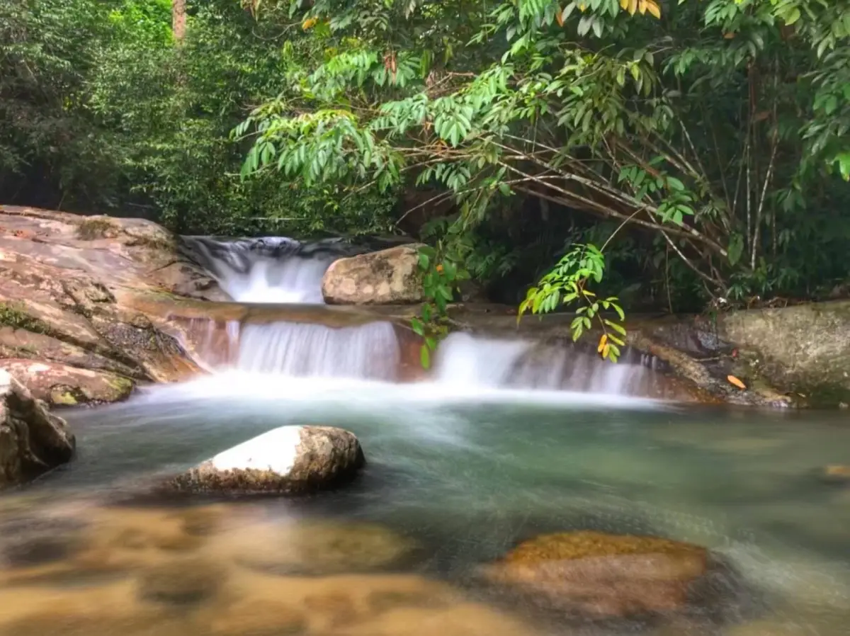
Sukthalai Waterfall, also known as Kuelong Waterfall, is a five-tier natural waterfall in the Southern Development Self-Help Settlement area on Khao Pok Yo, Taling Chan Subdistrict, Bannang Sata District, Yala Province. It is located behind the Kuelong Southern Development Settlement office, about 40 km from Yala city along Highway 410 on the Yala – Betong route, followed by an 8 km side road into the Kuelong settlement area. The waterfall is known for year-round water, cool forest air, shaded greenery, natural pools for safe water play, and pavilions for resting and picnicking.
Sukthalai Waterfall, formerly known as Kuelong Waterfall, is one of Bannang Sata District’s notable nature attractions. It lies within the Southern Development Self-Help Settlement area on Khao Pok Yo, Taling Chan Subdistrict, Yala Province. The surrounding landscape includes forest, hillside streams, rural settlement areas, and the Yala – Betong travel corridor. This makes the waterfall suitable for travelers who want a quiet natural stop, clear stream pools, and a shaded forest atmosphere without traveling deep into remote jungle terrain.
The waterfall was discovered in 1964 and consists of five tiers. It was later given the royal name “Sukthalai Waterfall” by Princess Srinagarindra, the Princess Mother. This royal name gives the site cultural and historical significance beyond its natural scenery. For local communities, the waterfall is not only a place for leisure but also a landmark tied to memory, settlement, and the identity of the Kuelong area.
The name Kuelong remains important because it is the older local name associated with the settlement and the waterfall area. Many travel sources therefore use both names together: Sukthalai Waterfall and Kuelong Waterfall. Using both names helps travelers identify the same place correctly, especially when asking directions from local residents or searching for the destination on Thai travel platforms.
The main charm of Sukthalai Waterfall is its tiered stream landscape. Rather than a single dramatic cliff drop, the water flows over natural rock surfaces and forms several pools along the course. These pools make the site suitable for careful water play in safe sections. Large trees and forest plants provide shade, keeping the atmosphere cool and comfortable even during the day.
Sukthalai Waterfall is also part of a headwater system that drains toward the Pattani River. This gives the site wider environmental importance. The water visitors see at the waterfall is connected to forest cover, soil moisture, local water use, and downstream communities. The health of the forest on Khao Pok Yo helps maintain water flow and supports the natural freshness that makes the waterfall attractive throughout the year.
Khao Pok Yo and Taling Chan Subdistrict form part of Bannang Sata’s inland mountain landscape. The area is known for forested hills, the Pattani River basin, village roads, and Highway 410, the major Yala – Betong route. Because of this position, Sukthalai Waterfall works well as a nature stop on a broader route that may include Bang Lang Dam, Kasot Forest Park, Tham Krachaeng Cave, Than To, Aiyoeweng, or Betong.
Access to the waterfall takes travelers from the main highway into the local settlement area. From Yala city, follow Highway 410 toward Bannang Sata for about 40 km, then turn left into the Kuelong settlement route for about 8 km. Once reaching Ban Talat Nikhom, signs lead toward the waterfall, which is about another 1 km from the village area. The road is not complicated, but visitors should drive carefully because some local sections may be narrow, wet, or have uneven mobile-phone signal.
The waterfall is suitable for families because it has natural pools where water play is possible in appropriate areas. However, as with any natural waterfall, visitors must pay attention to slippery rocks, variable water depth, and stronger flow after rain. Children should be supervised at all times, and water play should be limited to shallow sections where the bottom is visible and the current is not strong.
Rest pavilions near the waterfall make the site suitable for picnics and slow travel. Visitors can sit beside the stream, listen to the water, enjoy shade, and spend time with family or friends. This relaxed atmosphere is one of the strongest reasons to visit. Sukthalai Waterfall is best experienced as a calm local nature area, not as a rushed photo stop.
For photography, good subjects include water flowing over rock, clear green-blue pools, eroded stone textures, streamside roots, forest shade, and the resting pavilions. Morning and early afternoon are practical times because the light is softer and travelers still have enough time to leave the area before evening. Waterproof protection for phones or cameras is useful near the water.
Sukthalai Waterfall is appropriate for travelers who prefer quiet natural places rather than crowded commercial attractions. Yala Province is often known through Betong, Aiyoeweng Sea of Mist, and Bang Lang Dam, but smaller waterfalls like Sukthalai show another side of the province: forest streams, village landscapes, water resources, and community-based nature travel.
Recommended activities include waterfall viewing, careful swimming in safe pools, nature photography, resting under the trees, observing stream ecology, and learning about the headwater landscape of Khao Pok Yo. The site can be visited as a half-day stop from Yala city or included in a longer route through Bannang Sata toward Bang Lang Dam and the Yala – Betong mountain road.
The best time to visit is from morning to early afternoon. During the rainy season, the waterfall is greener and more active, but visitors should be alert to sudden water flow and slippery rocks. During drier periods, access is easier and the streamside environment is calmer, though the volume of water may vary naturally. In all seasons, visitors should check weather conditions before traveling.
Safety matters at Sukthalai Waterfall. Wear secure footwear, avoid wet rock surfaces, do not jump into pools where the depth is unknown, avoid the stream during heavy rain, and keep children close. The waterfall is generally suitable for relaxation, but natural water areas can become risky when visitors underestimate slippery ground or changing flow.
The waterfall also offers a useful lesson in local water-resource management. Because it is located behind the Southern Development Settlement office, the site reflects the close connection between forest, water, agriculture, and settlement. The stream does not exist only for sightseeing; it is part of the wider environmental system that supports local life in Taling Chan and Bannang Sata.
A practical one-day itinerary begins in Yala city in the morning. Drive along Highway 410 to Bannang Sata, turn into the Kuelong settlement area, and spend two to three hours at Sukthalai Waterfall for resting, photography, and water play. Afterward, continue to Bannang Sata town for food, visit Kasot Forest Park or Tham Krachaeng Cave, or extend the route to Bang Lang Dam for reservoir views.
Nearby attractions make the waterfall more useful as part of a travel route. Kasot Forest Park is a roadside nature stop in Bannang Sata. Tham Krachaeng Cave offers stream-and-cave scenery. Bang Lang Dam provides a large reservoir and mountain viewpoint. Than To Waterfall and Than To Lake extend the journey deeper toward the Yala – Betong route. Together, these places create a varied nature itinerary in inland Yala.
Food options are mainly found in Bannang Sata town and along the Yala – Betong route. Travelers can find halal food, cafés, local restaurants, mala restaurants, and simple community eateries. If continuing toward Bang Lang Dam, Ruen Balae Restaurant in the dam area is another option. Planning meal stops in advance helps keep the trip smooth, especially because services near the waterfall itself may be limited.
For accommodation, travelers can stay in Yala city for maximum convenience, at Bang Lang Dam for reservoir scenery, or farther toward Than To and Aiyoeweng for mountain and mist-view experiences. Sukthalai Waterfall is easy to visit as a daytime nature stop, so most visitors do not need to stay immediately near the waterfall unless they are planning a longer Bannang Sata or Yala – Betong nature route.
Getting There from Yala city is straightforward by private car, rental car, or local hired vehicle. Take Highway 410 toward Betong for about 40 km, then turn left into the Kuelong settlement road for about 8 km. From Ban Talat Nikhom, signs lead to Sukthalai Waterfall, about 1 km away. Visitors should drive slowly on local roads and avoid traveling during heavy rain if they are unfamiliar with the area.
Overall, Sukthalai Waterfall is a worthwhile nature attraction in Bannang Sata District. It combines a royal-name history, five waterfall tiers, year-round water, natural pools, shaded forest, picnic pavilions, and easy connection with the Yala – Betong route. For travelers seeking a quieter side of Yala, Sukthalai Waterfall offers a refreshing and culturally meaningful stop close to forest, water, and community life.
| Name | Sukthalai Waterfall |
| Former / Local Name | Kuelong Waterfall |
| Location | Southern Development Self-Help Settlement area on Khao Pok Yo, Taling Chan Subdistrict, Bannang Sata District, Yala Province |
| Address | Behind the Kuelong Southern Development Settlement office, Taling Chan Subdistrict, Bannang Sata District, Yala 95130, Thailand |
| Reference Coordinates | Latitude 6.31650, Longitude 101.35879 |
| Highlights | Five-tier natural waterfall, year-round water, cool forest air, natural pools, rest pavilions, and shaded Khao Pok Yo forest setting |
| History | Discovered in 1964 and given the royal name “Sukthalai Waterfall” by Princess Srinagarindra, the Princess Mother |
| Name Origin | Formerly known as Kuelong Waterfall after the Kuelong settlement area, later given the royal name Sukthalai Waterfall |
| Distinctive Features | Tiered forest waterfall with clear pools and a headwater stream flowing toward the Pattani River system |
| Travel Information | From Yala city, take Highway 410 toward Betong for about 40 km, then turn left into the Kuelong settlement road for about 8 km. From Ban Talat Nikhom, follow signs for about 1 km to the waterfall |
| Current Status | Open as a natural attraction in Taling Chan Subdistrict, suitable for relaxation, water play, and picnicking in a forest-stream setting |
| Open Days | Daily |
| Opening Hours | 09.00 – 17.00 |
| Entrance Fee | Free Entry |
| Facilities | Rest pavilions, picnic areas, natural pools, access route to the waterfall, and streamside relaxation areas |
| Main Areas / Zones | Waterfall tiers 1 – 5, natural pools, stream, rock formations, rest pavilions, shaded forest area, and Kuelong Southern Development Settlement office area |
| Caretaker / Coordinating Agencies | Southern Development Self-Help Settlement, Yala Province, and Taling Chan Subdistrict Administrative Organization, Bannang Sata District, Yala Province |
| Main Contact Number | Southern Development Self-Help Settlement, Yala Province Tel. 0-7326-1512 Taling Chan Subdistrict Administrative Organization Tel. 0-7328-2249 |
| Website / Information Sources | Yala Provincial Office of Tourism and Sports, Taling Chan Subdistrict Administrative Organization, CBT Thailand, Thailand Tourism Directory, LoveThailand.org, and Natural Site database |
| Nearby Tourist Attractions | 1. Kuelong Southern Development Settlement Office, about 1 km 2. Kasot Forest Park, Bannang Sata, about 18 km 3. Tham Krachaeng Cave, Bannang Sata, about 25 km 4. Bang Lang Dam, about 35 km 5. Than To Waterfall, Bang Lang National Park, about 45 km 6. Than To Lake, about 50 km |
| Nearby Restaurants | 1. Ajumma Bannang Sata Branch, about 18 km, Tel. 065-404-0064 2. Sep Thang Mala Bannang Sata, about 18 km, Tel. 064-013-7095 3. The Apple Yam, about 15 km, Tel. 093-459-4332 4. Riverside Bannang Sata, about 18 km, Tel. 088-395-1135 5. Santai Budaya, about 20 km, Tel. 093-714-6483 6. Ruen Balae Restaurant, Bang Lang Dam, about 35 km, Tel. 073-281-128 |
| Nearby Accommodations | 1. Khun Saichol Villa Bang Lang Dam, about 35 km, Tel. 073-281-129 2. Cool Camping Resort, about 60 km, Tel. 073-373-224, 084-313-7297, 081-897-5207 3. Resort Ban Saitan 21, about 60 km, Tel. 084-660-1380 4. The Linux Garden Hotel Yala, about 48 km, Tel. 073-299-578 5. Park View Hotel Yala, about 48 km, Tel. 073-217001-5 6. Yala Rama Hotel, about 50 km, Tel. 073-212563, 073-212815, 073-212841 |
Frequently Asked Questions (FAQ)
Q: Where is Sukthalai Waterfall located?
A: Sukthalai Waterfall is located in the Southern Development Self-Help Settlement area on Khao Pok Yo, Taling Chan Subdistrict, Bannang Sata District, Yala Province, behind the Kuelong Southern Development Settlement office.
Q: Is Sukthalai Waterfall the same as Kuelong Waterfall?
A: Yes. Kuelong Waterfall is the former or local name, while Sukthalai Waterfall is the royal name given by Princess Srinagarindra, the Princess Mother.
Q: How many tiers does Sukthalai Waterfall have?
A: Sukthalai Waterfall has five tiers, with year-round water, shaded forest surroundings, and natural pools suitable for careful water play.
Q: What are the opening hours?
A: The waterfall is open daily from 09.00 to 17.00. Morning to early afternoon is the best time for water play, photography, and leaving the area before evening.
Q: Is there an entrance fee?
A: Entry is free. Visitors should bring essential items and carry their trash out to help keep the natural area clean.
Q: Can visitors swim at Sukthalai Waterfall?
A: Water play is possible in safe natural pools, but visitors should watch for slippery rocks, stronger flow after rain, and changing water depth. Children should be supervised closely.
Q: How do travelers get to Sukthalai Waterfall?
A: From Yala city, take Highway 410 toward Betong for about 40 km, then turn left into the Kuelong settlement road for about 8 km. From Ban Talat Nikhom, follow signs for about 1 km to the waterfall.
Q: What nearby attractions can be combined with Sukthalai Waterfall?
A: Nearby options include Kasot Forest Park, Tham Krachaeng Cave, Bang Lang Dam, Than To Waterfall, Than To Lake, and the Yala – Betong route.
 Category: ●Nature and Wildlife
 Group: ●Waterfalls
Last Update : 2 WeekAgo
 Last Update : 2 WeekAgo
 Click to Access the Navigation Map GPS
Sukthalai Waterfall Map

 Art, Culture and Heritage
 Landmarks and Memorials(1)
 Art, Craft Centres, Tradition(2)
 Museums(2)
 Educational Places
 Educational Gardens, Farm(1)
 Places of Worship
 Temple(6)
 Mosque(2)
 Other Sacred Sites(3)
 Suburban Living
 Village, Community(4)
 National Parks and Marine Reserves(2)
 Mountain (Doi)(5)
 Dam, Reservoir, Lake(5)
Waterfalls(13)
Dam, Reservoir, Lake(5)
Waterfalls(13)
 Hot Springs(2)
 Caves(7)
 River, Canal(4)
 Islands(1)
 Other natural attractions(8)
 Entertainment and Agricultural
 Stadium(1)
 Farms, Parks and Ecotourism(4)
 Outdoor and Adventure Activities(1)
 Travel Articles, Recipes
 Travel Review, Food Review(2)


