
lovethailand home >South Travel Attractions >Yala Travel Attractions >Than To >Than To > Than To Waterfall
TL;DR: Than To Waterfall is located at Bang Lang National Park, Tham Thalu Subdistrict, Bannang Sata District, Yala Province, open Daily, except during seasonal recovery closures or safety closures announced by, hours 08.30 – 16.30.

Than To Waterfall
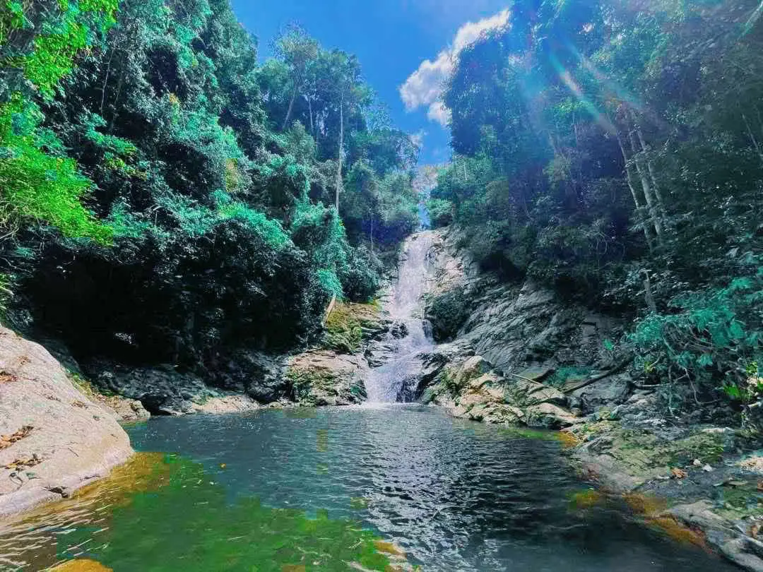
Open Days: Daily, except during seasonal recovery closures or safety closures announced by Bang Lang National Park
Opening Hours: 08.30 – 16.30
Than To Waterfall in Yala Province is a large natural waterfall inside Bang Lang National Park, located in Tham Thalu Subdistrict, Bannang Sata District, along Highway 410 on the Yala – Betong route. The access road branches about 1 km from the main highway. The waterfall is known for multi-tier cascades flowing down from a forested mountain, natural pools suitable for careful swimming, shaded rainforest scenery, rest pavilions in some sections, birdlife, and the yellow blossoms of the Sri Yala tree, also known as Yellow Asoka, which usually blooms around February. It is a strong nature stop for travelers heading through the Yala – Betong corridor.
Than To Waterfall is one of the most important natural attractions in Yala Province and a major visitor point within Bang Lang National Park. It is located in Tham Thalu Subdistrict, Bannang Sata District, on the scenic Highway 410 route connecting Yala city with Than To, Aiyoeweng, and Betong. The waterfall is convenient for road-trip travelers because it is only about 1 km from the main highway, making it suitable both as a planned waterfall visit and as a refreshing stop on the way to deeper southern Yala attractions.
The waterfall is best known for its water flowing down from a high mountain through rock channels and natural steps. The stream forms pools and cascades at different levels, surrounded by dense evergreen forest. The area feels cooler than open roadside stops because tall trees provide shade and moisture. The sound of flowing water, forest birds, and the shaded trail makes Than To Waterfall a suitable place for relaxation, photography, light nature walking, and careful swimming in safe pools.
The current travel description of Than To Waterfall presents it as a nine-tier waterfall. Each tier has its own name: Than Sam Sai, Than So Hin, Than Matcha, Than Krasen, Than Saneha, Than Dahla, Than Hin Tang, Than Phueksa, and Than To. The route from the first to the ninth tier is about 500 meters. Each tier can be reached by a walking path, while the third to fifth tiers have rest pavilions where visitors can sit and enjoy the forest and stream. The ninth and highest tier features water dropping from a cliff of about 30 meters.
The walking route is not extremely long, but it remains a natural waterfall trail. Visitors should expect wet stones, uneven ground, tree roots, slopes, and slippery sections. Proper footwear is important, especially during or after rain. Travelers who want to explore several tiers should allow enough time, walk slowly, and return before late afternoon. Good timing matters because forest trails become more difficult when the light fades.
The surrounding forest is one of the strongest reasons to visit. Bang Lang National Park covers parts of Bannang Sata, Than To, and Betong districts. It protects one of Yala’s important evergreen forest landscapes and headwater systems. The park is linked with the Pattani River, Sai Buri River, Khlong To Mo, Khlong Hala, and Khlong Ban Chet. Than To Waterfall is therefore more than a scenic stream; it is part of a broader forest-water system that supports ecosystems and downstream communities.
Bang Lang National Park has high biodiversity. Its rainforest supports local plants, rare wildlife, and many birds. The waterfall area is suitable for visitors interested in forest birdwatching, with species such as lesser green broadbill, chestnut-breasted malkoha, white-crowned forktail, crimson sunbird, and red-throated barbet reported from the broader waterfall environment. Nature-oriented visitors should move quietly and avoid disturbing wildlife.
A meaningful plant associated with the waterfall area is the Sri Yala tree, also known as Yellow Asoka. It is the provincial tree of Yala and produces bright yellow flowers around February. When the flowers appear against the green rainforest, the waterfall becomes especially attractive for nature photography. Travelers interested in plants and local identity should consider visiting around this period.
Than To Waterfall has natural pools suitable for water play in safe sections. These pools are formed where the stream slows down between rock levels. Visitors should swim only in shallow, calm, clearly visible areas and avoid strong currents, slippery rocks, or any restricted zone. Children must be supervised closely. Jumping from rocks is not recommended because natural pools may have uneven depth or hidden stones.
The waterfall can be visited as a half-day or full-day nature stop. For a half-day visit, travelers can focus on the lower tiers, rest near the stream, swim carefully, and take photographs. With more time, visitors can walk through more tiers, observe plants and birds, and connect the visit with Bang Lang National Park facilities or nearby attractions such as Bang Lang Dam and Than To Lake.
The best time to visit is from morning to early afternoon. The air is cooler, the light is better for photography, and visitors have enough time to leave the trail before evening. February is attractive because of the Sri Yala blossoms. The rainy season makes the forest greener and the waterfall more powerful, but it also increases the risk of slippery rocks, stronger current, and sudden water rise. The dry season offers easier walking, although water volume may vary naturally.
For photography, the waterfall offers many useful compositions: the entrance sign, shaded trail, flowing stream, natural pools, mossy rocks, rest pavilions, forest canopy, and the higher waterfall tiers. The best photographs usually come from safe, stable positions. Standing on wet rocks or climbing beyond marked areas for a better angle is not worth the risk. Waterproof protection for phones and cameras is useful because the forest is humid and water spray can reach equipment.
Than To Waterfall is also a good place to understand Yala’s headwater environment. The water visible at the waterfall is shaped by mountain rainfall, forest cover, soil, stream channels, and protected land management. When the forest remains healthy, the waterfall and streams remain cleaner and more stable. When forests are damaged, flash floods, erosion, and dry-season water problems become more likely. This makes the waterfall an accessible natural classroom.
Getting to the waterfall is easiest by private car, rental car, chartered van, or local hired transport. The site is close to Highway 410, but having a vehicle makes it easier to combine the waterfall with other Yala – Betong attractions. Public transport on the Yala – Betong route may pass the general area, but travelers should confirm drop-off points and local transport before relying on it.
From Yala city, take Highway 410 toward Bannang Sata and Betong for about 56 km, then turn from the main road into the waterfall access route for about 1 km. The route is part of the main Yala – Betong corridor and passes mountain landscapes, communities, and several nature attractions. Drivers should use caution, especially during rain, because sections of the route are curved and can be slippery.
Than To Waterfall works well as the main nature stop on a Bannang Sata – Than To – Betong itinerary. A practical plan is to leave Yala city in the morning, spend two to three hours at the waterfall, then continue to Bang Lang Dam or Than To Lake in the afternoon. Travelers continuing to Betong can use the same route through Than To and Aiyoeweng, with additional viewpoints, waterfalls, and mist-viewing areas along the way.
Nearby attractions include Bang Lang National Park, Bang Lang Dam, Than To Lake, La-ong Rung Waterfall, Hala-Zah Waterfall, Tham Thalu, and the broader Yala – Betong route. Each destination adds a different layer to the travel experience. Than To Waterfall provides forest and cascades; Bang Lang Dam and Than To Lake provide reservoir scenery; La-ong Rung Waterfall and Hala-Zah Waterfall show deeper forest-water landscapes within the Bang Lang area.
Families should choose activities according to the age and mobility of each member. Children and older travelers should focus on easier lower sections and safe resting points. Stronger walkers can explore more tiers, but they should avoid rushing and return before the forest becomes dark. Natural waterfalls require patience and caution, even when they are easy to reach from the road.
Useful items include non-slip footwear, a change of clothes, towel, waterproof phone pouch, drinking water, personal medicine, a trash bag, and light rain protection. Visitors planning to walk several tiers should avoid heavy luggage. Carry only necessary items because wet paths and uneven ground become harder to manage with bulky bags.
Water safety is essential. Natural rocks can be slippery even when they look dry. Visitors should avoid mossy rocks, strong currents, cliff edges, and jumping into pools. If the water becomes muddy, louder, or suddenly stronger, everyone should leave the stream immediately and move to higher safe ground.
Because Than To Waterfall is inside Bang Lang National Park, visitors should follow park rules strictly. Do not leave trash, feed wildlife, make loud noise, collect plants or stones, or damage any natural feature. Responsible travel keeps the waterfall clean, quiet, and usable for both local residents and future visitors.
Food options are available in Than To, Ban Hae, Bannang Sata, Bang Lang Dam, and Yala city. Travelers can bring light food for a simple rest stop or eat at restaurants along the route. Planning meals in advance is useful when combining several destinations in one day because services near forest attractions can be limited.
Accommodation depends on the travel plan. Visitors who want convenience can stay in Yala city and visit Than To Waterfall as a day trip. Those continuing toward Betong can stay in Than To, near Bang Lang Dam, or along the Aiyoeweng route for a more nature-focused itinerary. Travelers who prefer more restaurants and urban services may find Yala city or Betong town more convenient as a base.
Getting There from Yala city: follow Highway 410, the Yala – Betong route, toward Bannang Sata and Than To for about 56 km. Then turn into the waterfall access road for about 1 km. Private car, rental car, chartered van, or local hired transport is recommended. Check weather, drive carefully on mountain sections, and plan to leave the waterfall before evening.
Overall, Than To Waterfall is one of the most worthwhile nature attractions in Yala Province. It combines multi-tier cascades, evergreen forest, natural pools, walking trails, rest pavilions, birdlife, the Sri Yala tree, and easy connection with the Yala – Betong route. For travelers who want to experience Bang Lang National Park without going deep into remote forest, Than To Waterfall offers a balanced and rewarding nature stop.
| Name | Than To Waterfall |
| Location | Bang Lang National Park, Tham Thalu Subdistrict, Bannang Sata District, Yala Province |
| Address | Tham Thalu Subdistrict, Bannang Sata District, Yala 95130, Thailand, along Highway 410 on the Yala – Betong route |
| Reference Coordinates | Latitude 6.19667, Longitude 101.16385 |
| Highlights | Multi-tier rainforest waterfall, walking trail, natural pools, rest pavilions, shaded forest, birdlife, and Sri Yala or Yellow Asoka blossoms around February |
| Distinctive Features | Natural waterfall flowing from a forested mountain through rock channels, with a nine-tier walking route of about 500 m and the highest tier dropping from a cliff of about 30 m |
| Waterfall Tiers | Tier 1 Than Sam Sai Tier 2 Than So Hin Tier 3 Than Matcha Tier 4 Than Krasen Tier 5 Than Saneha Tier 6 Than Dahla Tier 7 Than Hin Tang Tier 8 Than Phueksa Tier 9 Than To |
| Importance | A key natural attraction of Bang Lang National Park, connected with rainforest, headwater systems, the Pattani River basin, forest ecology, and the Yala – Betong travel route |
| Travel Information | From Yala city, take Highway 410 toward Betong for about 56 km, then turn into the waterfall access road for about 1 km |
| Current Status | Open as a natural attraction of Bang Lang National Park outside seasonal recovery closures or safety closures announced by the park |
| Open Days | Daily, except during seasonal recovery closures or safety closures announced by Bang Lang National Park |
| Opening Hours | 08.30 – 16.30 |
| Entrance Fee | Current attraction listings show no entrance fee. If the park applies protected-area fees on the travel date, follow Bang Lang National Park’s official announcement |
| Facilities | Waterfall walking trail, natural pools, rest pavilions around tiers 3 – 5, streamside rest areas, selected parking areas, and Bang Lang National Park visitor facilities |
| Main Areas / Zones | Waterfall tiers 1 – 9, rainforest trail, stream, natural pools, rest pavilions, waterfall viewpoints, and Bang Lang National Park service area |
| Caretaker / Coordinating Agency | Bang Lang National Park, Department of National Parks, Wildlife and Plant Conservation |
| Main Contact Number | Bang Lang National Park Tel. 073-206119 Than To Subdistrict Administrative Organization Tel. 073-297-117 |
| Website / Information Sources | Bang Lang National Park, Tourism Authority of Thailand, CBT Thailand, LoveThailand.org, Wongnai, and public travel databases |
| Nearby Tourist Attractions | 1. Bang Lang National Park, about 3 km 2. Tham Thalu Cave, about 10 km 3. Bang Lang Dam, about 25 km 4. Than To Lake, about 30 km 5. La-ong Rung Waterfall, about 40 km 6. To Ku Chae-Kho Yae Bridge, about 45 km |
| Nearby Restaurants | 1. Café Amazon, Than To Self-Help Settlement Station, about 15 km, Tel. 095-967-3154 2. Krua Ka Areesah, about 20 km, Tel. 080-601-2609 3. Sila Café, Ban Hae, about 22 km, Tel. 065-024-9454 4. Sila, Ban Hae, about 22 km, Tel. 089-974-6373 5. Ruen Balae Restaurant, Bang Lang Dam, about 25 km, Tel. 073-281-128 6. Krua Muslim Restaurant, Bang Lang Dam, about 25 km, Tel. 093-606-0667, 084-890-7341 |
| Nearby Accommodations | 1. Resort Ban Saitan 21, about 36 km, Tel. 084-660-1380 2. Cool Camping Resort, about 40 km, Tel. 073-373-224, 081-897-5207 3. Yala Rama Hotel, about 40 km, Tel. 073-212563, 073-212815, 073-212841 4. Park View Hotel Yala, about 40 km, Tel. 073-217001-5 5. The Linux Garden Hotel Yala, about 38 km, Tel. 073-299-578 6. @INN YRU Hotel, about 39 km, Tel. 062-182-2662 |
Frequently Asked Questions (FAQ)
Q: Where is Than To Waterfall located?
A: Than To Waterfall is located inside Bang Lang National Park in Tham Thalu Subdistrict, Bannang Sata District, Yala Province, along Highway 410 on the Yala – Betong route.
Q: How many tiers does Than To Waterfall have?
A: The travel route of Than To Waterfall has nine tiers: Than Sam Sai, Than So Hin, Than Matcha, Than Krasen, Than Saneha, Than Dahla, Than Hin Tang, Than Phueksa, and Than To. The route is about 500 meters in total.
Q: What are the opening hours?
A: The waterfall is generally open daily from 08.30 to 16.30, except during seasonal recovery closures or safety closures announced by Bang Lang National Park.
Q: Can visitors swim at Than To Waterfall?
A: Swimming is possible in safe natural pools where the water is shallow and the current is gentle. Visitors should avoid slippery rocks, strong currents, and water play after heavy rain.
Q: Is there an entrance fee?
A: Current attraction listings show no entrance fee. If Bang Lang National Park applies protected-area fees on the travel date, visitors should follow the park’s official announcement.
Q: When is the best time to visit Than To Waterfall?
A: Morning to early afternoon is best for walking, swimming, and photography. February is also attractive because the Sri Yala or Yellow Asoka tree often blooms around this period.
Q: How do travelers get to Than To Waterfall?
A: From Yala city, take Highway 410 toward Betong for about 56 km, then turn into the waterfall access road for about 1 km.
Q: What nearby attractions can be combined with Than To Waterfall?
A: Good nearby options include Bang Lang National Park, Bang Lang Dam, Than To Lake, La-ong Rung Waterfall, Tham Thalu Cave, and the broader Yala – Betong route.
 Category: ●Nature and Wildlife
 Group: ●Waterfalls
Last Update : 2 WeekAgo
 Last Update : 2 WeekAgo
 Click to Access the Navigation Map GPS
 Art, Culture and Heritage
 Landmarks and Memorials(1)
 Art, Craft Centres, Tradition(2)
 Museums(2)
 Educational Places
 Educational Gardens, Farm(1)
 Places of Worship
 Temple(6)
 Mosque(2)
 Other Sacred Sites(3)
 Suburban Living
 Village, Community(4)
 National Parks and Marine Reserves(2)
 Mountain (Doi)(5)
 Dam, Reservoir, Lake(5)
Waterfalls(13)
Dam, Reservoir, Lake(5)
Waterfalls(13)
 Hot Springs(2)
 Caves(7)
 River, Canal(4)
 Islands(1)
 Other natural attractions(8)
 Entertainment and Agricultural
 Stadium(1)
 Farms, Parks and Ecotourism(4)
 Outdoor and Adventure Activities(1)
 Travel Articles, Recipes
 Travel Review, Food Review(2)


