
lovethailand home >South Travel Attractions >Yala Travel Attractions >Be Tong >Be Tong > Betong Mongkhonrit Tunnel
TL;DR: Betong Mongkhonrit Tunnel is located at Around The Junction Of Amornrit Road And Phakdi Damrong Road, Betong Subdistrict, Betong District, Yala Province, open Daily, hours 24 Hours.
Betong Mongkhonrit Tunnel
Open Days: Daily
Opening Hours: 24 Hours
Betong Mongkhonrit Tunnel in Yala Province is one of the most recognizable landmarks in Betong and one of the essential check-in points for visitors arriving in Thailand’s southernmost border town. Its main distinction is that it is widely known as Thailand’s first mountain road tunnel. Located in Betong Municipality, Betong District, Yala Province, around the junction of Amornrit Road and Phakdi Damrong Road, the tunnel connects the older town area with newer communities on the other side of the hill. It is both a practical transport route and a symbolic piece of urban infrastructure that has become part of Betong’s modern identity.
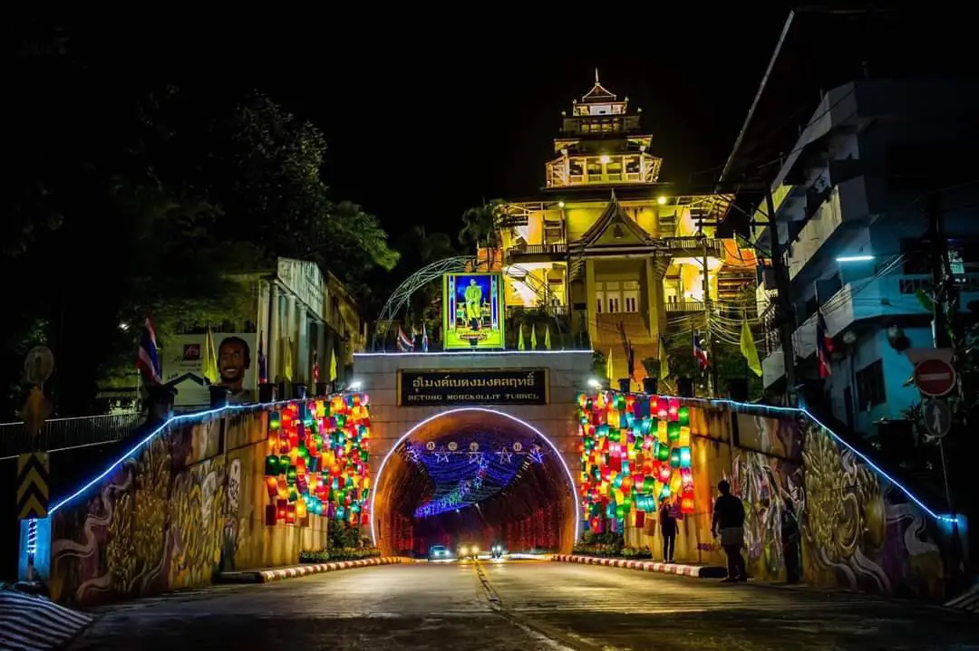
The tunnel is not only a passage for vehicles. It is also one of Betong’s most photogenic urban attractions. Cars and motorcycles use the tunnel throughout the day, while pedestrians can use the sidewalks along both sides. At night, decorative lights transform the curved tunnel into a bright and colorful photo spot. The lighting follows the shape of the tunnel and creates strong depth, making the location especially popular for night photography and city sightseeing.
The significance of Betong Mongkhonrit Tunnel begins with Betong’s geography. Betong is a border town surrounded by mountains, with many roads shaped by valleys and hills. The construction of a road tunnel through the hill helped improve travel between the older town center and newer residential areas. It reduced the limitation created by the mountain landscape and allowed the city to grow with better internal connectivity. For this reason, the tunnel shows that Betong is not only a destination of misty mountains, food, and the southernmost point of Thailand; it is also a town shaped by infrastructure and practical urban planning.
The tunnel is built with reinforced concrete and measures about 273 m in length, about 9 m in width, and about 7 m in height. The dual carriageway is about 7 m wide, while the sidewalks on both sides are about 1 m wide. These dimensions make the tunnel a substantial piece of civic engineering for a mountain town. Its curved form gives the passage a strong visual character, especially when lights reflect from the walls and the ceiling at night.
Betong Mongkhonrit Tunnel officially opened on 1 January 2001. Since then, it has become part of daily life for Betong residents. Local drivers pass through it to move between the town center and the communities beyond the hill, while travelers use the same place for photographs, evening walks, and short sightseeing stops. This combination of local utility and tourist appeal is what makes the tunnel especially interesting. It is not a decorative landmark built only for visitors; it remains an active public road used by the city every day.
During the daytime, the tunnel presents itself as a strong and functional urban structure. Visitors can see its portal, name sign, road surface, sidewalks, curved walls, and steady traffic flow. Daytime visits are useful for understanding the tunnel’s physical form and its role in connecting parts of the town. At night, however, the character changes completely. The light installations create a colorful and energetic atmosphere, turning the tunnel into one of Betong’s most popular nighttime landmarks.
Evening and nighttime are the most attractive periods for photography. From the front of the tunnel, visitors can capture the curved entrance, the illuminated ceiling, the rhythm of decorative lights, and the movement of passing vehicles. Wide-angle shots work especially well because the lines of the tunnel guide the eye inward. With careful timing, vehicle lights can add movement to the image. This makes the tunnel suitable for casual travelers, photography enthusiasts, and anyone who wants to capture Betong’s night atmosphere.
Safety is important because Betong Mongkhonrit Tunnel is a real traffic route. Visitors should stand on sidewalks, designated safe areas, or the side areas near the tunnel entrance. Do not stand in the traffic lane for photographs, do not block vehicles, and do not walk in blind spots. Families should keep children close at all times. Good photography at this site should never require unsafe positioning. The best visit is one that respects both the landmark and the daily traffic of local residents.
Near the tunnel entrance, visitors can also find the Betong chicken sculpture, another symbol of the district. Betong chicken is one of the town’s most famous food identities, and the sculpture has become a popular companion photo point near the tunnel. The tunnel, its illuminated portal, and the chicken sculpture together create a recognizable Betong city image. Nearby areas also connect with Betong Municipal Public Park, Betong City Museum, and the valley sports center, making the tunnel easy to include in a short walking route.
The tunnel route begins around Amornrit Road and Phakdi Damrong Road, passes through the public park area and out toward the road in front of the bird garden, then connects with Mongkhon Prachak Road toward the new town community around Grand View Village. It also links further with Aiyer Berjang Road toward the Than Nam Thip community. This alignment shows that the tunnel is not an isolated tourist attraction. It is a transport connector that opened movement between important parts of Betong.
The name Mongkhonrit carries a sense of auspiciousness, matching the tunnel’s role as a passage that helped open access across the town. Together with the name Betong, it has become easy to remember and strongly associated with the city. Many visitors first know the tunnel as a photo spot. After learning its history and walking around the site, however, they can see that its value is deeper: it changed urban movement, supported expansion, and became part of the shared memory of modern Betong.
The tunnel is also closely linked with Betong’s nighttime tourism. Betong after dark is known for food streets, the clock tower, the Giant Mailbox, and local restaurants. The tunnel adds another layer through light, form, and urban atmosphere. A simple evening route can begin at Betong Clock Tower and the Giant Mailbox, continue through local food areas, and end at Betong Mongkhonrit Tunnel for night photographs. This gives visitors a compact but complete sense of Betong’s central townscape.
Betong Clock Tower is located close to the tunnel and should be visited together. The clock tower is known for its marble structure and seasonal swallows, while the tunnel is known for its lights and curved engineering form. Visiting both during the evening shows two different sides of Betong: the older symbolic landmark at the center of town and the modern infrastructure that connects the city through the hill.
The Giant Mailbox is another nearby attraction often combined with the tunnel. It reflects Betong’s historic communication identity and remains one of the town’s most photographed symbols. Visitors can walk from the clock tower and the Giant Mailbox toward the tunnel within a short distance. This slower route allows travelers to see shops, restaurants, buildings, street life, and evening lights rather than only passing through by car.
Betong City Museum and the exhibition area near the tunnel help add historical context to the visit. Betong has a multicultural background shaped by Thai, Chinese, Malay, and cross-border influences. Stopping at the museum before or after seeing the tunnel helps visitors understand the town beyond its photo spots. Betong’s identity comes from settlement history, trade, transport, food culture, and its location near Malaysia.
Suan Sut Siam, or Betong Municipal Public Park, is also closely connected with the tunnel area. Located on the hill near the tunnel, the park includes viewpoints, gardens, a bird garden, health spaces, sports areas, a swimming pool, and a children’s playground. A good afternoon-to-evening plan is to visit the park for a hilltop view of Betong, then come down to the tunnel for nighttime lighting. This gives visitors both a high-level view of the city and a close urban night scene.
Betong Mongkhonrit Tunnel reflects Betong’s identity as an active border town. The town continues to develop public infrastructure, tourism spaces, and community activity areas. The tunnel began as a transport project but became a tourism symbol through lighting, landscaping, and its connection with nearby landmarks. This shows how a single place can serve several functions: mobility, recreation, photography, and city branding.
For first-time visitors, the tunnel should be included in a central Betong itinerary. The best timing is after dinner or during an evening walk near the clock tower. A basic visit takes around 20–30 minutes for photographs and a short look around. A longer route that combines the tunnel with the clock tower, Giant Mailbox, Betong City Museum, and Suan Sut Siam may take one to two hours and gives a better understanding of the town center.
Photography timing depends on the style visitors prefer. Daylight is suitable for clear structural images showing the concrete form, sidewalks, entrance sign, and road alignment. Evening and nighttime are better for light installations, colorful tunnel depth, and the moving lights of passing vehicles. Visitors should prepare camera settings before stepping into position and should avoid blocking traffic or standing in unsafe areas.
Getting to the tunnel within Betong town is easy because it is close to hotels, restaurants, and major landmarks. Travelers staying around Phakdi Damrong Road, Sukyang Road, Rattanakit Road, or the clock tower area can walk or take a short local ride to the tunnel. Drivers should park only in appropriate areas and continue on foot to the photo spots. The tunnel entrance itself is not a place for long stops because vehicles pass through continuously.
Getting There from Yala town to Betong involves a mountain road of about 140 km, passing through Than To District and scenic winding roads. Once in Betong, head toward Betong Mongkhonrit Tunnel or the junction of Amornrit Road and Phakdi Damrong Road. The tunnel connects onward to Mongkhon Prachak Road and newer areas of Betong. From Betong Clock Tower or the Giant Mailbox, the tunnel can be reached by a short walk or short drive.
The area around the tunnel is convenient for food and accommodation because it lies in central Betong. Visitors can plan a full city route around eating and sightseeing: dim sum or local Chinese food in the morning, central landmarks during the day, Suan Sut Siam in the evening, and tunnel photography at night. Betong is known for local dishes such as Betong chicken, kau yuk, stir-fried watercress, Betong noodles, dim sum, jee chong fun, and Betong grass jelly. Many well-known restaurants are within a short distance of the tunnel.
Accommodation near the tunnel ranges from large city hotels to long-established local hotels and budget-friendly places. Options around central Betong include Grand Mandarin Betong Hotel, Betong Merlin Hotel, Garden View Betong Hotel, Grandview Landmark Betong Hotel, Butterfly Princess Betong Hotel, and Penthouse Resort Betong. Staying within Betong Municipality makes it easier to reach the tunnel, clock tower, Giant Mailbox, markets, food streets, and nighttime photo spots.
The tunnel suits several types of travelers: photographers, urban explorers, families, first-time visitors to Betong, and anyone interested in city infrastructure. It does not take long to visit, but it leaves a strong visual memory. The name sign, tunnel lights, curved passage, and nearby Betong chicken sculpture immediately identify the location as Betong.
Compared with other Betong attractions, Betong Mongkhonrit Tunnel has a different role. Aiyerweng Sea Of Mist and Gunung Silipat show Betong’s mountain nature. The clock tower and Giant Mailbox show the town’s older civic identity. The tunnel shows modern transport infrastructure and the night image of the city. To understand Betong well, visitors should combine all three types: nature, old-town landmarks, and urban infrastructure.
Visitors should respect safety and local use. The tunnel is a public traffic route, not a closed photo studio. Do not stand in traffic lanes, set up tripods in unsafe places, climb structures, or block vehicles. Keep noise reasonable and avoid disturbing nearby residents or road users. Responsible behavior allows everyone to enjoy the landmark while keeping the road safe.
In summary, Betong Mongkhonrit Tunnel brings together several meanings of Betong: a mountain border town, practical urban development, the link between old and new communities, nighttime lighting, nearby local food, and a walkable central sightseeing route. It should not be seen only as a road tunnel. It is one of Betong’s modern symbols and a place where visitors can experience the town through movement, memory, and light.
| Name | Betong Mongkhonrit Tunnel |
| Location | Around The Junction Of Amornrit Road And Phakdi Damrong Road, Betong Subdistrict, Betong District, Yala Province |
| Address | Amornrit Road / Phakdi Damrong Road, Betong Subdistrict, Betong District, Yala 95110, Thailand |
| Reference Coordinates | 5.770397, 101.071563 |
| Highlights | Thailand’s first mountain road tunnel, about 273 m long, with attractive nighttime lighting and a strong identity as a central Betong photo landmark |
| History / Importance | Officially opened on 1 January 2001 to improve travel between the old town and newer communities of Betong. It has since become an important transport route and tourist landmark. |
| Name Origin | The name Mongkhonrit carries an auspicious meaning and reflects the tunnel’s role in opening a practical route through Betong’s hill landscape |
| Distinctive Features | Reinforced concrete tunnel, about 9 m wide and 7 m high, with a dual carriageway of about 7 m, sidewalks of about 1 m on each side, and a vehicle speed limit of around 60 km/h |
| Travel Information | From central Betong, head to the junction of Amornrit Road and Phakdi Damrong Road near Betong Municipal Public Park, Betong City Museum, Betong Clock Tower, and the Giant Mailbox. From Yala town, travel to Betong via the main mountain route, about 140 km. |
| Current Status | Open as a public road tunnel and central Betong photography landmark |
| Open Days | Daily |
| Opening Hours | 24 Hours |
| Fees | No Admission Fee |
| Facilities | Sidewalks on both sides of the tunnel, nighttime lighting, photo points near the tunnel entrance, city road connection, nearby parking where permitted, restaurants, and central Betong accommodation |
| Main Areas / Zones | Amornrit Road tunnel entrance, public park-side tunnel entrance, tunnel sidewalks, nighttime lighting area, Betong chicken sculpture, Suan Sut Siam connection, and area near Betong City Museum |
| Caretaker / Local Authority | Betong Municipality |
| Main Contact Number | Betong Municipality, Tel. 0-7323-1214 / 073-231-214 |
| Nearby Tourist Attractions | 1. Betong City Museum, about 20 m 2. Suan Sut Siam Or Betong Municipal Public Park, about 136 m 3. Valley Sports Center, about 140 m 4. Betong Giant Mailbox, about 230 m 5. Betong Clock Tower, about 300 m 6. Betong Central Mosque, about 470 m 7. Southernmost Point Of Thailand, about 7 km |
| Nearby Restaurants | 1. The Tunnel, about 100 m, Tel. 073-234-565 2. Thai Si Hee, about 200 m, Tel. 073-230-459 3. Ta Yern (Kitti), about 300 m, Tel. 073-230-461 4. Baiyok Restaurant, about 500 m, Tel. 086-964-4692, 073-230-763 5. Charoen Betong Chicken Rice, about 800 m, Tel. 084-015-2058 6. Ban Khun Chai Betong, about 2 km, Tel. 084-692-8074 |
| Nearby Accommodations | 1. Grand Mandarin Betong Hotel, about 200 m, Tel. 077-323-333, 073-235-777 2. Betong Merlin Hotel, about 300 m, Tel. 073-230-222 3. Garden View Betong Hotel, about 300 m, Tel. 073-235881-4, 086-488-7190 4. Grandview Landmark Betong Hotel, about 400 m, Tel. 073-245-510 5. Butterfly Princess Betong Hotel, about 1 km, Tel. 073-230-888, 081-963-8276 6. Penthouse Resort Betong, about 1 km, Tel. 073-230-644, 086-490-6478 |
Frequently Asked Questions (FAQ)
Q: Where Is Betong Mongkhonrit Tunnel Located?
A: Betong Mongkhonrit Tunnel is located around the junction of Amornrit Road and Phakdi Damrong Road in Betong Subdistrict, Betong District, Yala Province, close to Betong Municipal Public Park, Betong City Museum, Betong Clock Tower, and the Giant Mailbox.
Q: Why Is Betong Mongkhonrit Tunnel Important?
A: It is widely known as Thailand’s first mountain road tunnel. It officially opened on 1 January 2001 and helps connect Betong’s old town with newer communities beyond the hill.
Q: What Are The Opening Days And Hours?
A: The tunnel is open daily, 24 hours, because it is a public road tunnel. The most photogenic period is evening to nighttime when the decorative lights are illuminated.
Q: Is There An Admission Fee?
A: No. There is no admission fee. Visitors can stop for photographs without charge, but should stand only in safe areas and avoid blocking traffic.
Q: How Long Is Betong Mongkhonrit Tunnel?
A: The tunnel is about 273 m long, about 9 m wide, and about 7 m high. It has a dual carriageway and sidewalks on both sides.
Q: When Is The Best Time To Take Photos?
A: Nighttime is the most popular time because the tunnel lights create strong lines, color, and depth. Daytime is better for seeing the structure clearly.
Q: What Should Visitors Be Careful About?
A: The tunnel is an active traffic route. Visitors should stay on sidewalks or safe areas, avoid standing in traffic lanes, avoid blocking vehicles, and supervise children closely.
Q: Can Visitors Combine The Tunnel With Nearby Attractions?
A: Yes. Betong City Museum, Suan Sut Siam, the Valley Sports Center, Betong Giant Mailbox, Betong Clock Tower, and the southernmost point of Thailand can be combined in the same city route.
 Category: ●Nature and Wildlife
 Group: ●Other natural attractions
Last Update : 1 WeekAgo
 Last Update : 1 WeekAgo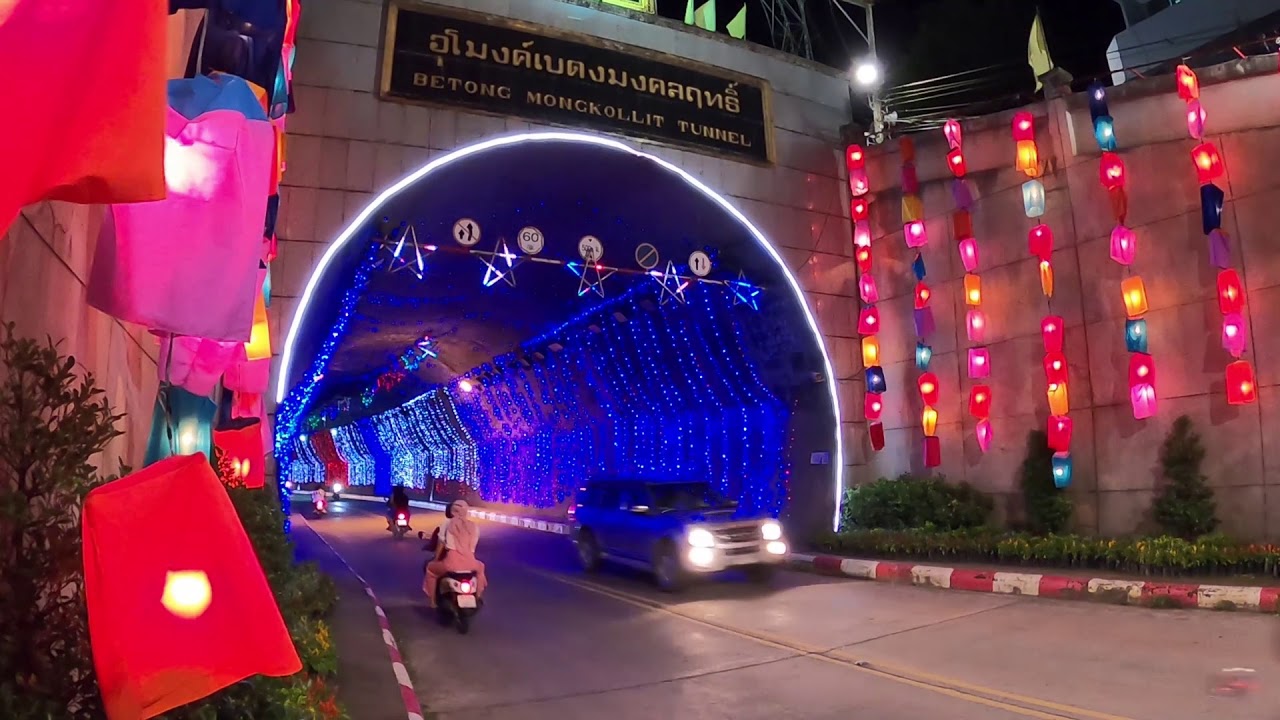
 Click to Access the Navigation Map GPS
Betong Mongkhonrit Tunnel Map

 Art, Culture and Heritage
 Landmarks and Memorials(1)
 Art, Craft Centres, Tradition(2)
 Museums(2)
 Educational Places
 Educational Gardens, Farm(1)
 Places of Worship
 Temple(6)
 Mosque(2)
 Other Sacred Sites(3)
 Suburban Living
 Village, Community(4)
 National Parks and Marine Reserves(2)
 Mountain (Doi)(5)
 Dam, Reservoir, Lake(5)
 Waterfalls(13)
 Hot Springs(2)
 Caves(7)
 River, Canal(4)
 Islands(1)
Other natural attractions(8)
Islands(1)
Other natural attractions(8)
 Entertainment and Agricultural
 Stadium(1)
 Farms, Parks and Ecotourism(4)
 Outdoor and Adventure Activities(1)
 Travel Articles, Recipes
 Travel Review, Food Review(2)


