
lovethailand home >South Travel Attractions >Trang Travel Attractions >Kan Trang >Kan Trang > Koh Rok
TL;DR: Koh Rok, Trang attractions : Nature and Wildlife, Islands.
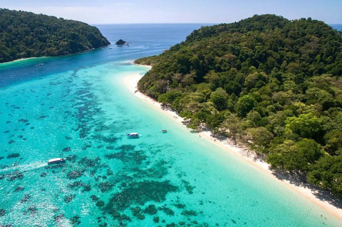
Koh Rok
Open Days: Seasonal access under Mu Ko Lanta National Park. In 2026, Ko Rok Nai and Ko Rok Nok are closed for tourism and overnight stays from 16 May – 31 October
Opening Hours: 08.30 – 16.30 during the open travel season
Koh Rok is a protected twin-island destination in Thailand’s Andaman Sea, administered by Mu Ko Lanta National Park in Krabi Province. The islands are best known for clear turquoise water, fine white sand, shallow coral reefs, and the rare feeling of being far from the busier beach towns of the Andaman coast. Koh Rok is not open all year. Travelers should plan visits during the official open season because the area closes during the monsoon period for marine recovery and boating safety.
Status updated on 8 September 2026: Koh Rok is not permanently closed. It is a seasonal marine national park destination. In 2026, Ko Rok Nai, Ko Rok Nok, Ko Ngai, Koh Haa, Hin Daeng, and Hin Muang are closed for tourism and overnight stays from 16 May to 31 October. The best planning window for a Koh Rok trip is therefore the open Andaman travel season after the park reopens, with final checks made before booking a boat tour or accommodation-linked excursion.
Koh Rok lies in Krabi waters close to the Trang sea route, which is why travelers can reach the islands from both Krabi and Trang. From Krabi, Koh Lanta is the most practical base, especially around Saladan Pier and the main west-coast beach areas of Ko Lanta Yai. From Trang, travelers often start from Pak Meng Beach or nearby piers connected with the Trang island route. Travel time depends on departure point, boat type, and sea conditions. Most visitors choose a full-day group tour, while overnight camping-style stays are available only when permitted by the national park during the open season.
The appeal of Koh Rok comes from the combination of bright water, white beaches, coastal forest, and accessible snorkeling reefs. The islands are managed as part of Mu Ko Lanta National Park, so travel is controlled through seasonal access, boat regulations, designated landing areas, snorkeling points, waste rules, and conservation guidelines. Because Koh Rok is farther offshore than many popular islands, the atmosphere feels calmer and more natural. Travelers who value clear water, healthy reefs, soft sand, and protected island scenery often regard Koh Rok as one of the strongest snorkeling destinations in the central Andaman Sea.
Koh Rok consists of two main islands: Ko Rok Nok and Ko Rok Nai. The two islands face each other across a shallow sea channel of about 250 metres. This geography creates one of the most recognizable views of Koh Rok. From the beach, visitors see pale turquoise water in the foreground and the opposite island rising across the channel. On sunny days, the sea shifts from light blue in the shallows to deeper blue where the water drops. Several coral areas sit close enough to the islands for guided snorkeling during calm sea conditions.
Ko Rok Nok is the island most visitors use as the main landing area. It is home to the national park ranger unit known as Mu Ko Lanta National Park Ranger Unit 1, Koh Rok. The front beach of Ko Rok Nok has fine white sand stretching along the shore, with clear water suitable for swimming when the sea is calm. Coral reefs are found to the south of the island. Ko Rok Nok is more than a beach stop: it also has walking routes, a rear rocky bay, a viewpoint, and a mixed coastal forest environment.
The main beach of Ko Rok Nok is the classic Koh Rok image: white sand, transparent water, and forest shade behind the shore. During full-day tours, visitors usually rest on this beach, swim, take photos, and eat lunch in the area arranged by the tour operator or park staff. The water is often clear enough to reveal changing tones of blue near the shore. Visitors should use the beach responsibly by taking all rubbish back, avoiding wildlife feeding, and leaving shells, corals, and natural objects where they belong.
From the ranger unit on Ko Rok Nok, a walking trail leads to Ao Thalu on the rear side of the island. Ao Thalu is a rocky bay with a curved shape often compared to a horseshoe. It has a very different character from the white-sand front beach. At low tide, visitors can see unusual rock shapes and natural colours along the shore. This area suits travelers who want to see more than the standard beach scene. Footwear matters here because rocks can be uneven or slippery, especially after rain or sea spray.
Pha Samed Daeng Viewpoint is another important feature of Ko Rok Nok. The viewpoint is named after the red-barked Samed tree growing near the cliff. From this high point, visitors can see the Trang island group and, on clear days, views reaching toward Koh Lanta. The viewpoint helps explain Koh Rok’s position between the Krabi and Trang marine routes. Travelers on a day tour should manage time carefully because the walk, photos, beach time, and snorkeling all need to fit within the boat schedule.
Ao Man Sai lies beyond the main beach toward the end of Ko Rok Nok. At low tide, visitors can walk along the beach to reach the bay. The bay is known for a large banyan tree whose hanging roots fall like a curtain, giving the area its distinctive name and mood. The forest around Ao Man Sai combines mangrove, beach forest, and tropical evergreen forest elements. The beach in front of the bay has white sand with a comfortable slope for swimming when conditions are safe. Ao Man Sai often feels quieter than the main beach because many day visitors remain near the front landing area.
Ko Rok Nai sits opposite Ko Rok Nok and has several sites with a different identity. Hat San Chao is the only sandy beach on Ko Rok Nai. It faces east toward Ko Rok Nok and the shallow channel between the two islands. The sea in front of Hat San Chao and the channel area is one of the best-known snorkeling zones at Koh Rok. Guided snorkelers can see hard corals, soft corals, sea anemones, and many reef fish in relatively shallow water during clear conditions. This channel is one reason Koh Rok is widely associated with accessible snorkeling rather than only deep-water diving.
The name Hat San Chao is linked to the Chao Mae Tubtim shrine built by fishermen. The shrine contains many large and small phallic offerings brought by fishermen to honour Chao Mae Tubtim, reflecting the beliefs of people who depend on the sea for travel and livelihood. This part of Ko Rok Nai gives the island a cultural layer in addition to its marine scenery. Visitors should behave respectfully around the shrine and avoid moving or touching offerings left by local worshippers.
South of Hat San Chao is Laem Siam, where an old Siam boundary pillar from the reign of King Rama V still stands. Although the pillar has aged, its presence gives Ko Rok Nai historical meaning beyond beach tourism. The site points to the maritime geography and boundary history of Thailand in the Andaman Sea. Near the pillar area, there is also a bay suitable for snorkeling in permitted conditions. Laem Siam therefore combines a historical marker and a natural marine setting in one area.
Ao Hin Ngam, near Ao Lak Khet on the southern side of Ko Rok Nai, is known for stones of varied shapes and natural colours. Its coastline differs from the soft white sand of the main landing beach, giving visitors another view of Koh Rok’s coastal landscape. In front of the shore, wide coral areas create another snorkeling point around Ko Rok Nai. Ao Hin Ngam is a useful stop for travelers who want to understand how the islands combine beaches, rock formations, coral reefs, and forested slopes within a compact marine national park setting.
On the southwest or rear side of Ko Rok Nai is the Koh Rok Nai waterfall. The water flows down from the high ridge and descends toward the sea, creating one of the island’s natural signatures. The waterfall has water mainly during the rainy season and into early November. During the dry season or late in the travel season, the flow can be far less visible. Travelers who want to see this feature should plan for the right season and follow only permitted routes.
Snorkeling is the main activity at Koh Rok. The best-known areas include the channel between Ko Rok Nok and Ko Rok Nai, the sea in front of Hat San Chao, the southern coral areas of Ko Rok Nok, and reef zones near Ao Hin Ngam. The strong appeal is visibility: on calm days, visitors can see coral gardens and reef fish clearly through the water. Snorkelers should wear life jackets, listen to guides, avoid standing on coral, avoid touching marine life, and never chase fish. These simple behaviours directly protect the reefs that make Koh Rok worth visiting.
Koh Rok suits several types of travelers. Families can enjoy beach time, guided swimming areas, and beginner-friendly snorkeling spots. Nature-focused travelers can see beach forest, mangrove-influenced areas, tropical evergreen forest, coral reefs, and rocky shorelines. Travelers interested in local culture can connect the Chao Mae Tubtim shrine, the Siam boundary pillar, and the fishing-community beliefs with the marine landscape. Koh Rok is therefore not only a beach destination. It is also a compact field lesson in Andaman coastal ecology and maritime culture.
The best time to visit Koh Rok is during the Andaman open season after the monsoon closure. November to April is generally the most comfortable period for travelers because seas are usually calmer, visibility is better, and boat access is more reliable than during the monsoon months. Early in the season, the islands have had time to recover during closure. Near the end of the season, travelers should watch weather and sea conditions more closely. A successful Koh Rok trip depends on more than scenery: safe boat operation, clear water, and official park permission all matter.
Getting There requires a tour boat, charter boat, or licensed tour package. There is no regular public ferry service to Koh Rok. From Koh Lanta, travelers usually depart from the Saladan area or other tour pick-up points on Ko Lanta Yai. This route suits visitors staying in Krabi or on Koh Lanta. From Trang, travelers can depart from Pak Meng Beach or connected Trang piers, especially when combining Koh Rok with Ko Muk, Emerald Cave, Ko Kradan, Ko Chueak, Ko Ma, or Ko Ngai. The sea journey from Pak Meng is about 47 kilometres and usually takes around 2 hours in normal sea conditions.
Travelers coming from Krabi can stay on Koh Lanta for one night before joining a morning tour to Koh Rok. This reduces travel fatigue and makes the early start easier. Travelers coming from Trang can base themselves near Pak Meng and combine the trip with the Trang island route. The Trang route is useful for those who want a broader central Andaman itinerary with Ko Muk, Emerald Cave, Ko Kradan, Ko Chueak, Ko Ma, and Ko Ngai. The practical choice depends on where the traveler stays, the boat schedule, the season, and the sea forecast.
A full-day Koh Rok tour suits travelers with limited time. A typical program includes hotel pick-up or meeting-point transfer, boat travel to Koh Rok, guided snorkeling stops, lunch on the beach, swimming, photos, and return in the afternoon. This format is easy to manage because the operator provides the boat, guide, and snorkeling equipment. Overnight camping or park-based stays suit travelers who want quieter time after day boats leave, but overnight arrangements must follow national park rules and should be checked directly with the park before travel.
Preparation for Koh Rok should focus on comfort and conservation. Useful items include swimwear, quick-dry towels, hat, sunglasses, dry bag, sandals or water shoes, reef-friendly sunscreen, and personal medication. Travelers prone to seasickness should prepare motion-sickness medicine and take it according to professional advice before departure. Bringing a reusable bottle and a personal rubbish bag helps reduce the impact on the island. Visitors should not litter, collect shells, touch coral, stand on coral, feed fish, or disturb wildlife.
The entrance fee for Koh Rok is the Mu Ko Lanta National Park fee. The fee is 40 baht for Thai adults, 20 baht for Thai children, 200 baht for foreign adults, and 100 baht for foreign children. Vehicle-related fees are separate where applicable. Some boat tour packages include the national park fee, while others charge it separately. Travelers should read package details before booking to avoid duplicate payment or misunderstanding at the pier.
The main areas to know before visiting are the front beach of Ko Rok Nok, Ao Thalu, Pha Samed Daeng Viewpoint, Ao Man Sai, Hat San Chao on Ko Rok Nai, Chao Mae Tubtim Shrine, Laem Siam, the old Siam boundary pillar, Ao Hin Ngam, and the Koh Rok Nai waterfall. Knowing these areas helps visitors understand the islands as more than a single beach stop. Koh Rok rewards travelers who take time to notice its paired-island geography, coral habitats, coastal forest, cultural shrine, and historical boundary marker.
Koh Rok is best for travelers who want a protected Andaman island experience with clear water and natural scenery. The journey takes more planning than visiting an island close to shore, but the reward is a memorable combination of white sand, blue water, coral reefs, and the distinctive twin-island setting. With the right season, a licensed boat operator, and respect for national park rules, Koh Rok can be one of the most rewarding sea trips in Krabi and Trang.
| Name | Koh Rok |
| Location | Mu Ko Lanta National Park, Ko Lanta District, Krabi Province, in the Andaman Sea near the Trang marine route |
| Address | Ko Lanta Yai Subdistrict, Ko Lanta District, Krabi Province 81150, Thailand |
| Coordinates | Ko Rok Nok approx. 7.22082, 99.06907 / Ko Rok Nai approx. 7.20462, 99.06176 |
| Highlights | Twin islands, white sand beaches, clear turquoise water, shallow coral reefs, snorkeling sites, and protected national park scenery |
| Distinctive Features | Ko Rok Nok and Ko Rok Nai face each other across a shallow sea channel of about 250 metres, with beaches and snorkeling areas on the inner sides of the islands |
| History / Protection Status | Part of Mu Ko Lanta National Park and managed as a seasonal marine tourism area to protect natural resources and boating safety |
| Travel Information | No regular public ferry. Travelers must use a licensed tour boat, private charter, or organized tour package from Koh Lanta in Krabi or Pak Meng Beach in Trang |
| Current Status | Seasonal access, not permanently closed. In 2026, Ko Rok Nai and Ko Rok Nok are closed for tourism and overnight stays from 16 May – 31 October |
| Open Days | Seasonal access under Mu Ko Lanta National Park |
| Opening Hours | 08.30 – 16.30 during the open travel season |
| Fees | Thai adults 40 baht, Thai children 20 baht, foreign adults 200 baht, foreign children 100 baht |
| Facilities | Ranger unit area, beach rest area, nature trails, swimming areas, snorkeling points, and seasonal overnight/camping areas under national park conditions |
| Main Areas / Zones | Ko Rok Nok, Ranger Unit 1, Ko Rok Nok Front Beach, Ao Thalu, Pha Samed Daeng Viewpoint, Ao Man Sai, Ko Rok Nai, Hat San Chao, Chao Mae Tubtim Shrine, Laem Siam, Siam Boundary Pillar, Ao Hin Ngam, Koh Rok Nai Waterfall |
| Caretaker | Mu Ko Lanta National Park and National Park Ranger Unit 1, Koh Rok |
| Main Contact Number | Mu Ko Lanta National Park, Tel. 082-816-6885 |
| Official Website / Official Page | Tourism Authority of Thailand and Mu Ko Lanta National Park |
| Nearby Tourist Attractions | 1. Ko Rok Nai, about 0.3 km 2. Ko Rok Nok, about 0.3 km 3. Ko Kradan, about 23 km 4. Ko Ngai, about 24 km 5. Koh Haa, about 30 km 6. Ko Muk / Emerald Cave, about 30 km |
| Nearby Restaurants | 1. Chedi Restaurant / SriLanta Resort and Spa, about 36 km, Tel. 086-661-6886, 083-394-6661 2. Tropicana Lanta Resort Restaurant, about 36 km, Tel. 098-254-2596, 081-895-9718 3. Coco Loco Restaurant and Bar, about 47 km, Tel. 075-684-175 4. Ruen Thai Restaurant, about 47 km, Tel. 075-684-175 5. 432 Restaurant and Bar, about 47 km, Tel. 075-684-200, 081-358-9482 |
| Nearby Accommodations | 1. Pimalai Resort and Spa, about 31 km, Tel. 075-607-999 2. SriLanta Resort and Spa, about 36 km, Tel. 086-661-6886, 083-394-6661 3. Southern Lanta Resort, about 47 km, Tel. 075-684-175 4. Twin Lotus Resort and Spa, about 47 km, Tel. 075-607-000 5. Lanta Sand Resort and Spa, about 45 km, Tel. 075-684-633-4 6. Costa Lanta, about 47 km, Tel. 087-717-0593 |
Frequently Asked Questions (FAQ)
Q: Is Koh Rok open all year?
A: No. Koh Rok is a seasonal marine national park destination. In 2026, Ko Rok Nai and Ko Rok Nok are closed for tourism and overnight stays from 16 May to 31 October.
Q: What is the best month to visit Koh Rok?
A: The best period is usually November to April, when the Andaman Sea is calmer, visibility is better, and snorkeling conditions are more reliable.
Q: Which province is Koh Rok in?
A: Koh Rok is in Mu Ko Lanta National Park, Ko Lanta District, Krabi Province, but it lies close to the Trang sea route and can be reached from both Koh Lanta and Trang.
Q: Where do boats to Koh Rok depart from?
A: Boats usually depart from Koh Lanta in Krabi or Pak Meng Beach in Trang. Travelers must use a licensed tour boat, private charter, or organized tour package.
Q: Is there a public ferry to Koh Rok?
A: No. There is no regular public ferry to Koh Rok. Visitors need to join a tour, charter a boat, or book a licensed marine excursion.
Q: Is Koh Rok good for snorkeling?
A: Yes. Koh Rok is one of the best-known snorkeling spots in the central Andaman Sea, with clear water, shallow coral reefs, and snorkeling areas around the channel, Hat San Chao, and Ao Hin Ngam.
Q: Can travelers stay overnight on Koh Rok?
A: Overnight stays are possible only when the national park permits them during the open season. Travelers should check directly with Mu Ko Lanta National Park before planning an overnight trip.
Q: Do visitors need to pay a national park fee?
A: Yes. The Mu Ko Lanta National Park fee is 40 baht for Thai adults, 20 baht for Thai children, 200 baht for foreign adults, and 100 baht for foreign children.
 Category: ●Nature and Wildlife
 Group: ●Islands
Last Update : 4 WeekAgo
 Last Update : 4 WeekAgo
 Click to Access the Navigation Map GPS
Koh Rok Map
Gellery
Recommend

 Art, Culture and Heritage
 Historical Sites and Monuments(1)
 Landmarks and Memorials(2)
 Art, Craft Centres, Tradition(3)
 Museums(2)
 Places of Worship
 Temple(15)
 Mosque(1)
 Other Sacred Sites(6)
 Research and Development
 Royal Project(1)
 Suburban Living
 Village, Community(5)
 National Parks and Marine Reserves(6)
 Mountain (Doi)(8)
 Dam, Reservoir, Lake(1)
 Waterfalls(20)
 Hot Springs(1)
 Caves(11)
 Bays and Beaches(11)
Islands(12)
Bays and Beaches(11)
Islands(12)
 Other natural attractions(3)
 Entertainment and Agricultural
 Farms, Parks and Ecotourism(8)
 Outdoor and Adventure Activities(1)
 Travel Articles, Recipes
 Travel Review, Food Review(1)
 Southern Food Menu, Southern Food Recipes(1)


