
lovethailand home >Northeastern Travel Attractions >Udon Thani Travel Attractions >Na Yung >Na Yung > Yung Thong Waterfall
TL;DR: Yung Thong Waterfall is located at Na Yung-Nam Som National Park, Moo 2, Ban Sawang, Na Yung Subdistrict, Na Yung District, Udon Thani Province, open Daily, hours 08.30 – 16.30.
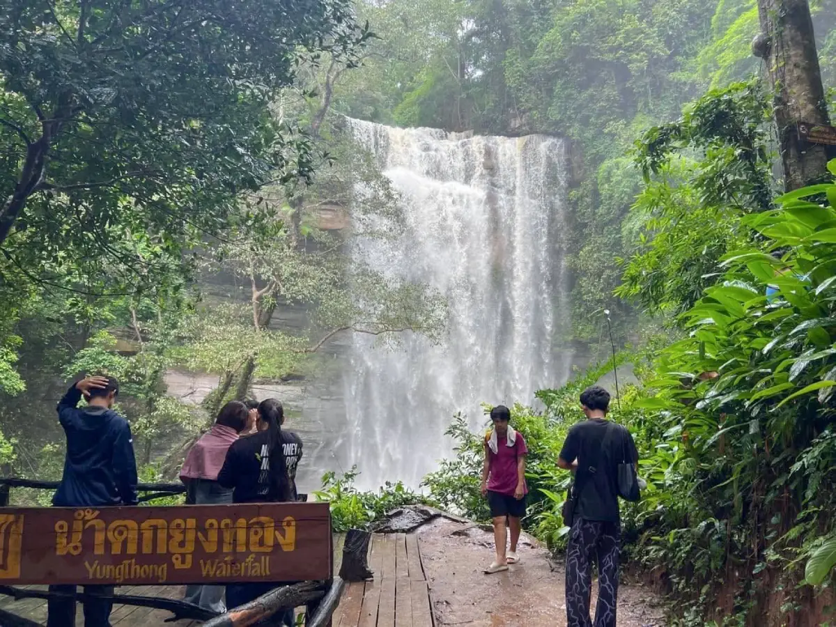
Yung Thong Waterfall
Open Days: Daily
Opening Hours: 08.30 – 16.30
Yung Thong Waterfall in Udon Thani Province is a natural waterfall located inside Na Yung-Nam Som National Park, at Moo 2, Ban Sawang, Na Yung Subdistrict, Na Yung District, Udon Thani. The waterfall sits on the mountain ridges of Phu Phan and Phu Ya U, where a stream flows beautifully through complex rock formations amid green forest and diverse plant life. Yung Thong Waterfall is a small 3-level waterfall located about 103 km from Udon Thani city. It is suitable for travelers who want to experience forest scenery, a nature trail, cool waterfall air, rock streams, and a quieter natural side of Udon Thani.
Yung Thong Waterfall is one of the main attractions of Na Yung-Nam Som National Park, an area connected with Udon Thani, Loei, and Nong Khai provinces. The most popular visitor points are in the Udon Thani section, especially Yung Thong Waterfall, Tad Noi Waterfall, and Pha Daeng Viewpoint. The park has developed a nature study trail for visitors to learn about forest ecology, mountain terrain, streams, sandstone rocks, and local plant life along the route. This trail is about 2,000 meters long and passes Yung Thong Waterfall, Tad Noi Waterfall, and Pha Daeng Viewpoint, making it a rewarding route for travelers who want more than a quick waterfall stop.
The main character of Yung Thong Waterfall comes from water flowing through layered rocks and complex sandstone formations. The stream descends naturally through 3 small levels. During the rainy season, the water volume increases, the flow becomes stronger, and cool mist forms around some parts of the waterfall. This makes the area especially fresh and lively. During the late rainy season and early cool season, the forest remains green, the air becomes more comfortable, and the trail to the waterfall and viewpoint is pleasant for walking. Yung Thong Waterfall therefore shows Udon Thani as a province with mountains, streams, and forest trails, not only temples and archaeological sites.
The landscape of Na Yung-Nam Som National Park is mountainous and complex, with elevations of roughly 200 – 500 meters above sea level. The highest mountain in the area is Phu Ya U, about 588 meters high. This terrain creates important headwaters such as Huai Nam Som and Huai Tad Ton. Most of the rock in the area is sandstone. When water flows across and between these stone layers, it creates natural channels, cascades, pools, and rock textures that form the character of Yung Thong Waterfall. The waterfall is therefore both a scenic attraction and a visible example of how water shapes sandstone landscapes over time.
The forest around Yung Thong Waterfall includes dry dipterocarp forest, mixed deciduous forest, and dry evergreen forest along stream areas. Important tree species include teng, rang, hiang, phluang, rosewood, pradu, makha tae, several kinds of bamboo, yang, krabak, takhian, tabaek, and makha mong. Epiphytes such as orchids and ferns can also be found in the broader forest environment, along with lower vegetation such as rattan, palms, and medicinal plants. This diversity gives the trail a shaded and living atmosphere, turning a visit to the waterfall into a broader forest experience.
The name “Yung Thong” carries a memorable local identity. The area has been associated with peafowl habitat in the past, and the name reflects both natural beauty and the richness of the forest. Today, travelers mainly come to see the waterfall, but the name still suggests an older forest memory connected with wildlife and plant diversity. Visiting Yung Thong Waterfall is therefore also a way to experience a landscape where water, forest, and local memory remain linked.
Yung Thong Waterfall has 3 levels, each shaped by the rocks, slope, and seasonal water flow. The lower level is suitable for beginning the visit and taking photos of the stream and forest, while the upper sections feel more natural as the trail moves closer to the rock formations and shaded forest. Visitors should stay on the marked trail, avoid shortcuts, and not climb wet rocks. During the rainy season, soil, roots, and stone surfaces can become slippery, so proper footwear is important.
The Yung Thong nature study trail is one of the most valuable features of the park. It links several key places in one route: Yung Thong Waterfall, Tad Noi Waterfall, and Pha Daeng Viewpoint. The total walking distance is about 2,000 meters, with interpretive signs placed along the trail to explain natural features. Travelers can learn about forest types, plants, streams, rock formations, and the mountain environment while walking. This makes the route suitable for visitors who want a half-day nature experience with clear points of interest.
Tad Noi Waterfall is a nearby attraction that can be visited together with Yung Thong Waterfall because it lies on the same nature trail. The area has stream scenery, rocks, forest shade, and photo spots that continue the natural atmosphere of Yung Thong Waterfall. Walking onward to Tad Noi allows visitors to see how the stream changes across different sections of the route, with water sounds, stone surfaces, and forest vegetation creating a more complete nature experience.
Pha Daeng Viewpoint is another important point on the same route. It is about 1,500 meters from the park office. Pha Daeng is a steep sandstone cliff that offers a broad view of the landscape below. Near the cliff is a small rock shelter once associated with meditation practice by Luang Pu Mun Bhuridatta. This gives the area both natural and spiritual value. A walk from Yung Thong Waterfall to Pha Daeng combines waterfall scenery, forest shade, sandstone cliffs, and a quiet place connected with Thai Buddhist meditation history.
The best time to visit Yung Thong Waterfall is from the rainy season to the early cool season. From June to October, the waterfall is at its most powerful, with stronger water flow and lush forest. From November to February, the weather becomes cooler and more comfortable for walking, while the forest often remains green after the rains. The hot season is still possible for a visit, but water levels may be lower. Travelers who want to see the waterfall at its best should plan a trip after a period of consistent rainfall or during the late rainy to early cool season.
Traveling from Udon Thani city to Yung Thong Waterfall usually follows the route through Ban Phue District and Nam Som District. From the Nam Som area, the road branches from Ban Nam Suem village and continues for about 17 km toward the park entrance. The local road is generally suitable for private vehicles. Visitors should use a navigation app together with road signs and local directions. Once inside the park, vehicles should be parked only in designated areas before walking along the official nature trail.
Getting There from Udon Thani city is best done in the morning. The waterfall is about 103 km from the city, making it suitable for a day trip if travelers start early. A private car, rental car, or hired vehicle with a driver is the most practical option. The trip should allow enough time for Yung Thong Waterfall, Tad Noi Waterfall, and Pha Daeng Viewpoint. Families and elderly visitors should assess walking ability before entering the trail because some sections include slopes, soil paths, natural rocks, and forest surfaces.
Public transportation is less practical for this route because the park is far from the city and located in a natural area. International travelers should plan the route in advance, keep mobile internet available for navigation, and travel during daylight hours. This destination is best for visitors who enjoy natural places and are comfortable traveling beyond city areas to reach forest and mountain landscapes.
Useful items to bring include non-slip walking shoes, drinking water, a hat, mosquito repellent, breathable clothing, a small towel, a personal trash bag, and waterproof protection for phones or cameras. During the rainy season, a light rain jacket or waterproof bag is recommended. Proper preparation helps visitors walk safely and reduces the impact on the national park environment.
Visitors should stay on marked trails, avoid climbing wet rocks, avoid entering strong-flow water sections, keep noise low, avoid feeding wildlife, leave plants and rocks where they are, and carry all trash back out. The waterfall and surrounding forest are part of a living ecosystem. Responsible behavior keeps the area clean, quiet, and healthy for future visitors.
Yung Thong Waterfall is suitable for many kinds of travelers. Families can use the trail as a nature learning route for children. Groups of friends can enjoy walking, photography, and resting near the stream. Solo travelers can spend quiet time with the forest and water. Foreign visitors can experience a side of Isan that is very different from the common image of open plains and rice fields, because this area has mountains, waterfalls, forest, sandstone cliffs, and viewpoints within one route.
For a practical one-day itinerary, travelers can leave Udon Thani city early, arrive at the national park in the late morning, visit Yung Thong Waterfall first, then continue to Tad Noi Waterfall and Pha Daeng Viewpoint. Around 2 – 4 hours is suitable for walking, resting, and photography. After the visit, travelers can return to Na Yung or Nam Som for food before driving back to Udon Thani city in the evening. Those who want to stay overnight can choose accommodation or camping in the park area, Na Yung District, Nam Som District, or Udon Thani city according to their route.
The park area provides basic facilities such as toilets, food, shops, parking, and visitor support for elderly travelers, parents, and children. Travelers planning to camp, stay overnight, or walk up to viewpoints later in the day should contact the park in advance for current conditions and safety guidance. Natural trail conditions can change with weather, rainfall, and park management decisions.
Yung Thong Waterfall also has educational value as a forest ecosystem. It shows how mountains, forest, sandstone, streams, and seasonal rainfall work together. The stream flowing through complex rocks creates small cascades, pools, and natural channels, while the forest protects moisture and supports many plant species. Visitors who walk slowly and observe carefully will notice many natural details along the trail.
In summary, Yung Thong Waterfall is a 3-level waterfall inside Na Yung-Nam Som National Park, at Ban Sawang, Moo 2, Na Yung Subdistrict, Na Yung District, Udon Thani Province. It is located on the Phu Phan and Phu Ya U mountain ridges, about 103 km from Udon Thani city. The waterfall is known for its stream flowing through beautiful and complex rock formations, surrounded by lush forest. It can be visited together with Tad Noi Waterfall, Pha Daeng Viewpoint, and the 2,000-meter nature study trail. With good preparation and respect for park rules, Yung Thong Waterfall is one of Udon Thani’s most rewarding nature destinations.
| Name | Yung Thong Waterfall |
| Location | Na Yung-Nam Som National Park, Moo 2, Ban Sawang, Na Yung Subdistrict, Na Yung District, Udon Thani Province |
| Address | Na Yung-Nam Som National Park, Moo 2, Ban Sawang, Na Yung Subdistrict, Na Yung District, Udon Thani 41380, Thailand |
| Highlights | A small 3-level waterfall on the Phu Phan and Phu Ya U mountain ridges, with water flowing through complex rock formations amid lush forest |
| History | Located in Na Yung-Nam Som National Park, a forest and mountain area connected with Udon Thani, Loei, and Nong Khai provinces and important headwater streams of the northern Phu Phan landscape |
| Name Origin | The name “Yung Thong” is linked with local memory of peafowl habitat and reflects the natural beauty of the forest around the waterfall |
| Distinctive Features | Three waterfall levels, a stream flowing through sandstone rocks, shaded forest, and a nature trail connecting Tad Noi Waterfall and Pha Daeng Viewpoint |
| Travel Information | From Udon Thani city, travel through Ban Phue District and Nam Som District, then branch from Ban Nam Suem village for about 17 km toward the park entrance; private car, rental car, or hired vehicle is recommended |
| Current Status | Open as a natural attraction of Na Yung-Nam Som National Park |
| Open Days | Daily |
| Opening Hours | 08.30 – 16.30 |
| Fees | National park entrance fee: adults 20 – 80 baht, children 10 – 40 baht, according to the park’s applicable rate |
| Facilities | Toilets, food, shops, parking, and visitor support for elderly travelers, parents, and children in the park area |
| Main Areas / Zones | Yung Thong 3-level waterfall zone Tad Noi Waterfall zone Pha Daeng Viewpoint zone 2,000-meter nature study trail zone Stream and sandstone rock zone Park office and visitor service zone |
| Caretaker | Na Yung-Nam Som National Park under Thailand’s national park and forest conservation authorities |
| Main Contact Number | Na Yung-Nam Som National Park, Tel. 085-6461352 Na Yung Subdistrict Municipality, Tel. 042-132604 |
| Official Website / Official Page | Na Yung-Nam Som National Park and Smart DASTA |
| Nearby Tourist Attractions | 1. Tad Noi Waterfall, about 1 km 2. Pha Daeng Viewpoint, about 2 km 3. Luang Pu Mun Bhuridatta meditation rock shelter, about 2 km 4. Wat Tham Si Mongkhon, about 7 km 5. Wat Pa Na Kham Noi, about 9 km 6. Phiang Pho Di Rest Stop, about 8 km 7. Nam Som District, about 25 km |
| Nearby Restaurants | 1. Phiang Pho Di Rest Stop, about 8 km, Tel. 081-712-8004 2. Im Di Kai Yang Na Yung, about 10 km, Tel. 083-335-8887 3. Song Ton Mookata, about 9 km 4. Krua Champa Si Ton, about 11 km 5. Khanom Chin Mae Phen, about 12 km 6. Krua Kru Phayao, about 17 km |
| Nearby Accommodations | 1. Na Yung-Nam Som National Park accommodation and campground, about 1 km, Tel. 085-6461352 2. Baan Suan Mee Suk Na Yung Resort, about 10 km 3. Na Yung Accommodation, about 10 km, Tel. 087-572-5368 4. Wut Chok Hotel Nam Som, about 27 km 5. Accommodations in Nam Som District, about 25 km |
Frequently Asked Questions (FAQ)
Q: Where is Yung Thong Waterfall located?
A: Yung Thong Waterfall is located inside Na Yung-Nam Som National Park, Moo 2, Ban Sawang, Na Yung Subdistrict, Na Yung District, Udon Thani Province.
Q: What days is Yung Thong Waterfall open?
A: Yung Thong Waterfall is open daily from 08.30 to 16.30. Daylight travel is recommended for safe nature walking.
Q: Is there an entrance fee for Yung Thong Waterfall?
A: Yes. The national park entrance fee is 20 – 80 baht for adults and 10 – 40 baht for children, depending on the applicable park rate.
Q: What makes Yung Thong Waterfall special?
A: It is a small 3-level waterfall where water flows through complex rock formations amid the green forest of the Phu Phan and Phu Ya U mountain ridges.
Q: When is the best time to visit Yung Thong Waterfall?
A: The rainy season to early cool season is the best time to visit because the waterfall has good water flow, the forest is green, and the weather is suitable for walking.
Q: How can travelers get to Yung Thong Waterfall?
A: From Udon Thani city, travel through Ban Phue District and Nam Som District, then branch from Ban Nam Suem village for about 17 km toward the park entrance. Private transport is recommended.
Q: Is Yung Thong Waterfall suitable for families?
A: It is suitable for families who enjoy nature, but children and elderly visitors should be supervised because some trail sections include natural soil, rocks, and slopes.
Q: What nearby places can be visited after Yung Thong Waterfall?
A: Nearby places include Tad Noi Waterfall, Pha Daeng Viewpoint, Luang Pu Mun Bhuridatta meditation rock shelter, Wat Tham Si Mongkhon, and Wat Pa Na Kham Noi.
 Category: ●Nature and Wildlife
 Group: ●Waterfalls
Last Update : 2 MonthAgo
 Last Update : 2 MonthAgo
 Click to Access the Navigation Map GPS
Yung Thong Waterfall Map
Recommend

 Art, Culture and Heritage
 Historical Sites and Monuments(1)
 Landmarks and Memorials(1)
 Art, Craft Centres, Tradition(2)
 Museums(2)
 Places of Worship
 Temple(21)
 Other Sacred Sites(8)
 Suburban Living
 Village, Community(3)
 National Parks and Marine Reserves(3)
 Mountain (Doi)(1)
 Dam, Reservoir, Lake(8)
Waterfalls(6)
Dam, Reservoir, Lake(8)
Waterfalls(6)
 Caves(1)
 River, Canal(4)
 Islands(1)
 Other natural attractions(1)
 Entertainment and Agricultural
 Farms, Parks and Ecotourism(3)
 Waterpark(1)
 Shopping
 Shopping and Night Market(1)


