
lovethailand home >Northeastern Travel Attractions >Nong Khai Travel Attractions >Sang Khom >Ban Muang > Ang Pla Buek
TL;DR: Ang Pla Buek is located at Ban Nong, Ban Muang Subdistrict, Sangkhom District, Nong Khai Province, open Daily, hours Open-air Mekong riverside viewpoint; best visited during daylight hours.
Ang Pla Buek
Open Days: Daily
Opening Hours: Open-air Mekong riverside viewpoint; best visited during daylight hours, especially in the morning and late afternoon
Ang Pla Buek, also known locally as Nong Pla Buek, is a natural Mekong riverside viewpoint in Ban Nong, Ban Muang Subdistrict, Sangkhom District, Nong Khai Province. The place is known for its seasonal river landscape. When the Mekong River level drops, parts of the riverbed appear as rock formations, sandbars, clear pools, and a basin-like area in the middle of the river. This creates a simple but memorable natural scene where travelers can sit by the water, enjoy the breeze, take photographs, and experience the quieter side of the Mekong in upper northeastern Thailand.
The appeal of Ang Pla Buek does not come from large buildings or commercial attractions. Its beauty comes from the river itself. The Mekong changes shape throughout the year, and this seasonal transformation is what makes the place special. During the high-water period, the area appears as a wide flowing river with forested hills and the Lao landscape in the distance. During the low-water period, rocks, sandy patches, and clear natural pools emerge from the river, revealing a hidden landscape that is normally covered by water.
Ang Pla Buek is ideal for travelers who want to see the Mekong in a calm and local setting. Unlike riverside points in larger towns, this viewpoint feels more intimate and closer to nature. Visitors can observe the river’s changing water level, the exposed rocks in the dry season, and the quiet atmosphere of a rural Mekong village. The experience is especially suitable for slow travelers, landscape photographers, and people driving along the Nong Khai-Sangkhom-Chiang Khan route.
The name Ang Pla Buek reflects the relationship between the Mekong River and the Mekong giant catfish, one of the most symbolic freshwater fish of the river. Today, natural Mekong giant catfish are rare and travelers should not expect to see them in the wild. Even so, the name of the place preserves a memory of the river’s depth, abundance, and cultural importance. The image of a clear natural basin in the Mekong, together with rocks and broad water, helps visitors understand why this riverside area has become meaningful to the local community.
Arriving at Ban Nong in Ban Muang Subdistrict, travelers will find that Ang Pla Buek works well as a restful stop on a scenic drive. Sangkhom District is one of Nong Khai’s most attractive riverside districts, with the Mekong River, hills, viewpoints, temples, waterfalls, and communities along the road. Ang Pla Buek is a good place to pause, breathe, stretch, take photographs, and enjoy the wind from the Mekong before continuing toward Sangkhom town, Wat Pha Tak Suea, or Chiang Khan in Loei Province.
The scenery at Ang Pla Buek changes according to the Mekong water level. On high-water days, the river looks broad, deep, and powerful. On low-water days, the character of the river becomes more detailed, with exposed stone, sand, shallow pools, and textured riverbed surfaces. These features make the area more visually interesting and more closely connected with the seasonal rhythm of the Mekong. Late afternoon light makes the water and rocks especially photogenic.
Ang Pla Buek is also part of the wider Ban Muang community tourism route. Ban Muang Subdistrict has natural resources, mountain viewpoints, Mekong scenery, village products, weaving, dried banana production, gold panning along the Mekong, and local learning activities. Visiting Ang Pla Buek is therefore not just about stopping at a riverside sign. It can be part of a deeper journey into the natural and cultural life of the Ban Muang community.
Geographically, Ang Pla Buek represents the distinctive character of the Mekong around Sangkhom District. This section of the river differs from the stretch near Nong Khai city. Around Sangkhom, the landscape is shaped by hills, river bends, seasonal rock formations, and exposed riverbed features during low water. These natural elements give Sangkhom a stronger adventure-and-scenery identity while still remaining peaceful and rural.
Visitors should understand that the most dramatic view of Ang Pla Buek depends on season and water level. If travelers want to see the rock formations, sandbars, and basin-like pool clearly, the low-water season is the best period. If visiting during high water, the exposed rocks may not be visible, but the viewpoint still offers a wide Mekong panorama, breezy riverside atmosphere, and views toward the Lao side.
The best time of day to visit is in the morning or late afternoon. Morning offers cool air, soft light, and a quiet local atmosphere. Late afternoon is especially beautiful because the lowering sun brings warm light to the water surface and creates a peaceful riverside mood. Ang Pla Buek is a good sunset stop for travelers driving along the Mekong road, but visitors should leave the water’s edge before the area becomes dark.
A typical visit does not need to be long. Many travelers spend 30 minutes to 1 hour here, taking photos, resting by the river, and enjoying the natural view. Those who prefer slow travel may stay longer to watch the light change, observe the rocks, and experience the rhythm of the Mekong. This is a place for quiet appreciation rather than fast sightseeing.
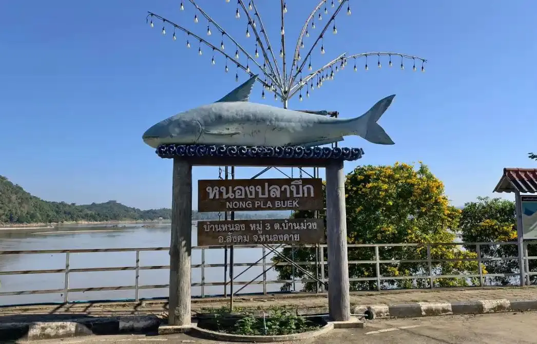
For photography, Ang Pla Buek offers several useful compositions. Visitors can photograph the Nong Pla Buek sign and giant fish sculpture, the Mekong River with the Lao hills behind it, the exposed rocks during low water, sandy riverbed sections, and the sunset over the water. The scenery has a calm, natural, and rural character that represents Sangkhom District well.
Safety is important because Ang Pla Buek is located beside the Mekong River. Water levels and currents can change with season and upstream conditions. Visitors should not swim, walk on wet or slippery rocks, or go too close to the water’s edge. During rainy weather, after rain, or when the river is rising, extra caution is necessary. Photographs should be taken only from stable and safe areas.
Although the viewpoint is easy to access, visitors should respect the local community. Avoid making loud noise, blocking local roads, leaving rubbish, climbing on signs or structures, or disturbing local residents. Small riverside places like Ang Pla Buek remain beautiful only when visitors help keep them clean and treat the area as a shared community space.
Culturally, Ang Pla Buek is connected with the Mekong and local memory of large river fish. In communities along the Mekong, the river is linked with livelihoods, food, travel, belief, and identity. The name Pla Buek does not only refer to a fish. It also evokes the depth, abundance, and legendary character of the Mekong, a river that has supported both Thai and Lao communities for generations.
Ang Pla Buek also helps travelers understand the broader tourism route of Sangkhom District. The area can be combined with Phu Pha Dak, mist viewpoints, Ban Muang community experiences, Wat Pha Tak Suea Skywalk, nearby waterfalls, and other Mekong viewpoints. A well-planned route can include river scenery, mountain views, local food, temples, and community-based tourism in a single day or overnight trip.
Travelers coming from Nong Khai city can use Ang Pla Buek as a stop on the way to Sangkhom or Chiang Khan. The riverside route is especially suitable for self-drive travel because it allows visitors to stop at scenic points when the light and weather are favorable. Those leaving Nong Khai in the morning can visit riverside viewpoints, stop at Ang Pla Buek, continue to Phu Pha Dak, and then visit Wat Pha Tak Suea Skywalk if time allows.
Travelers coming from Chiang Khan or Loei can also use Ang Pla Buek as a peaceful stop before entering Nong Khai Province. The Mekong road between Chiang Khan and Sangkhom is one of the most atmospheric river routes in northeastern Thailand. Stopping at Ang Pla Buek adds a clear view of the seasonal Mekong riverbed and helps travelers see how this part of the river differs from the more developed riverside towns.
The visitor experience at Ang Pla Buek can be divided into several zones. The first is the Nong Pla Buek sign and photo point. The second is the Mekong view and Lao mountain scenery zone. The third is the exposed rocks and sandbar zone during low water. The fourth is the clear basin-like pool zone that appears seasonally. The fifth is the sunset-viewing zone along the river. The sixth is the connection zone leading into Ban Muang community tourism and the Sangkhom travel route.
The Nong Pla Buek sign zone is the most convenient place for a quick photo. The sign and fish sculpture clearly identify the location and connect the place with the Mekong giant catfish theme. It is a good memory shot for travelers on the riverside road. Visitors should take turns if others are waiting and remain aware of nearby traffic or roadside movement.
The Mekong view and Lao mountain scenery zone is the heart of the place. From this point, visitors can enjoy the width of the river, the wind, and the layered view of water, sky, and distant hills. On clear days, the Lao side adds depth to the panorama and makes the location feel open and peaceful.
The exposed rock and sandbar zone appears most clearly when the Mekong level is low. This is the most distinctive natural feature of Ang Pla Buek. Rocks and sand emerge from the riverbed, forming patterns that are different every season. Visitors should admire this area carefully and avoid stepping onto wet rocks or unstable surfaces.
The seasonal clear-pool zone is the natural feature that gives the place its basin-like character. When the water level drops, some parts of the river surface can look like clear pools among rocks and sand. This is visually beautiful, but it remains part of the Mekong River, so visitors should not treat it as a swimming area.
The sunset-viewing zone is best for travelers who want a quiet evening experience. As the sun lowers, the water becomes softer in color and the rocks gain more contrast. This is one of the most rewarding times to photograph Ang Pla Buek. Visitors should plan to return to the road before full darkness, especially if they are not familiar with the route.
The Ban Muang community connection zone gives the visit more meaning. Ban Muang has local products, food, riverside life, mountain scenery, and community learning activities. Spending time at nearby cafes, restaurants, or community businesses helps turn a scenic stop into a more complete travel experience.
Getting There is easiest by private car or motorcycle. Set the destination as Ban Nong, Ban Muang Subdistrict, Sangkhom District, Nong Khai Province, or search for Nong Pla Buek Ban Muang Sangkhom on an online map. From Nong Khai city, follow the road toward Sangkhom along the Mekong route. Because the distance is longer than city attractions, travelers should check the vehicle, fuel, and route before departure.
Driving on the Nong Khai-Sangkhom route should be done carefully. Some sections run along the river and pass through villages, curves, and sloping areas. It is better to drive at a moderate speed, especially in the evening after sunset. Travelers unfamiliar with the road should allow enough time to reach accommodation before dark.
Travelers without their own vehicle can first travel to Sangkhom District and then arrange a local vehicle to Ban Nong or Ban Muang. It is best to agree on the price and return time in advance because Ang Pla Buek is a riverside stop rather than a transport hub with frequent public vehicles.
Ang Pla Buek can be combined with other attractions in Sangkhom District, such as Phu Pha Dak, Ban Muang mist viewpoints, Wat Pha Tak Suea Skywalk, Than Thip Waterfall, Than Thong Waterfall, and other Mekong viewpoints. Travelers who stay overnight in Sangkhom can enjoy both morning mist and evening riverside light, which are two of the district’s strongest natural charms.
Useful items for a visit include comfortable shoes, drinking water, a hat, sun protection, a camera, and a light jacket during the cool season. If walking near the exposed rocks during low water, shoes with good grip are important. Visitors should not walk alone onto unstable riverbed areas because dry-looking rocks may still be slippery.
Families with children should supervise them closely. The viewpoint is next to the Mekong River, and not every part has a protective barrier. Children should not run near the water’s edge or walk onto exposed rocks without adult supervision. Older visitors should remain at stable viewpoints and avoid sloping or slippery areas.
For international travelers, Ang Pla Buek offers a useful introduction to the local Mekong landscape. It is more than a photo spot. It shows the connection between water level, rock formations, river culture, local memory, and community identity. Visiting this small riverside point gives a deeper perspective on Nong Khai beyond its markets, temples, and border landmarks.
In summary, Ang Pla Buek or Nong Pla Buek in Ban Nong, Ban Muang Subdistrict, Sangkhom District, Nong Khai Province, is a seasonal Mekong viewpoint known for its basin-like water area, exposed rocks, sandbars, clear pools, sunset scenery, Lao mountain views, and peaceful community atmosphere. It is best visited in daylight, especially during the low-water season and late afternoon. Travelers should choose safe viewpoints, avoid entering the river, respect the local community, and enjoy the slow beauty of the Mekong in Sangkhom.
| Name | Ang Pla Buek / Nong Pla Buek |
| Location | Ban Nong, Ban Muang Subdistrict, Sangkhom District, Nong Khai Province |
| Address | Mekong Riverside Area, Ban Nong, Village No. 3, Ban Muang Subdistrict, Sangkhom District, Nong Khai Province 43160, Thailand |
| Highlights | Seasonal Mekong basin, exposed rocks, sandbars, clear water, Mekong view, and sunset scenery in Sangkhom District |
| History / Area Context | A natural Mekong riverside attraction of Ban Muang community, connected with the seasonal rock landscape of the river and local memory of the Mekong giant catfish |
| Name Origin | The name refers to a basin-like or pond-like area in the Mekong and the community’s connection with the Mekong giant catfish, a symbolic large fish of the river |
| Distinctive Features | When the Mekong level drops, exposed rocks, rock beaches, sandbars, and clear basin-like pools appear in the river, making it suitable for scenery viewing, photography, and riverside relaxation |
| Travel Information | Best reached by private car or motorcycle along the Nong Khai-Sangkhom route. Set the destination as Ban Nong, Ban Muang Subdistrict, or Nong Pla Buek Ban Muang Sangkhom, Nong Khai Province |
| Current Status | Open as a natural Mekong riverside viewpoint and community check-in point in Ban Muang, Sangkhom District |
| Open Days | Daily |
| Opening Hours | Open-air Mekong riverside viewpoint; best visited during daylight hours, especially in the morning or late afternoon |
| Facilities | Riverside check-in point, Nong Pla Buek sign, Mekong viewpoint, roadside resting area, and local shops and restaurants in Ban Muang community |
| Main Areas / Zones | 1. Nong Pla Buek Sign And Riverside Photo Point 2. Mekong River And Lao Mountain View Zone 3. Exposed Rocks, Rock Beach, And Sandbar Zone During Low Water 4. Seasonal Clear Basin Zone In The Mekong 5. Mekong Sunset Viewing Zone 6. Ban Muang Community And Creative Tourism Connection Zone |
| Caretaker | Ban Muang Subdistrict Administrative Organization, Sangkhom District, Nong Khai Province, and Ban Nong community |
| Main Contact Number | Ban Muang Subdistrict Administrative Organization, Tel. 042-414871, Fax 042-414872 |
| Official Website / Official Page | www.banmuang-sao.go.th / Facebook: Ban Muang Subdistrict Administrative Organization, Sangkhom District, Nong Khai Province |
| Nearby Tourist Attractions | 1. Phan Khod Saen Khrai, about 3 km 2. Phu Pha Dak Ban Muang Mist Viewpoint, about 8 km 3. Ban Muang Border Checkpoint Area, about 5 km 4. Wat Pa Ban Wang Mon, Ban Muang Subdistrict, about 12 km 5. Sangkhom Town And Mekong Riverside Area, about 22 km 6. Than Thip Waterfall, about 32 km 7. Wat Pha Tak Suea And Skywalk, about 38 km |
| Nearby Restaurants | 1. Bingsu Phu Tawan @ Ban Nong, about 1 km, Tel. 093-1296422 2. 188 CAFE CAMP, about 10 km, Tel. 089-4225002 3. Plai Tawan Cafe, Ban Phu Khao Thong, about 12 km 4. Nang Chill Rim Khong, about 22 km, Tel. 061-8239595 5. Kin Im Rim Khong Restaurant, about 22 km, Tel. 084-3390957 6. Tawan Restaurant, Sangkhom District, about 23 km, Tel. 085-5022723 |
| Nearby Accommodations | 1. Phop Kan Homestay & Cafe, Ban Phu Khao Thong, about 12 km, Tel. 092-4926366 2. Bengkhong Sangkhom Resort Hotel, about 24 km, Tel. 081-0530058 3. Forest Park Resort, about 24 km, Tel. 089-3765680 4. Suan Nam Ban Suan & Resort, about 24 km, Tel. 085-2811160 5. Sam Noom Resort, about 35 km, Tel. 081-2601828 6. Banmai Rimkong Resort, about 35 km, Tel. 086-6306176 |
Frequently Asked Questions (FAQ)
Q: Where is Ang Pla Buek located?
A: Ang Pla Buek, also known as Nong Pla Buek, is located at Ban Nong, Ban Muang Subdistrict, Sangkhom District, Nong Khai Province, along the Mekong River.
Q: Is Ang Pla Buek open to visitors?
A: Yes. It is open as a natural Mekong riverside viewpoint and community check-in point. It is best visited during daylight hours.
Q: When is the best time to visit Ang Pla Buek?
A: Morning and late afternoon are the best times for scenery and photography. The low-water season is the best time to see exposed rocks, sandbars, and the basin-like pool in the Mekong.
Q: Is there an admission fee for Ang Pla Buek?
A: Ang Pla Buek is a community riverside viewpoint, not a ticketed attraction with an entrance gate.
Q: What is special about Ang Pla Buek?
A: Its highlights include the seasonal basin-like water area in the Mekong, exposed rocks, sandbars, clear water, Lao mountain views, the Nong Pla Buek sign, and sunset scenery.
Q: How do travelers get to Ang Pla Buek?
A: Travel by private car or motorcycle along the Nong Khai-Sangkhom route, and set the destination as Ban Nong, Ban Muang Subdistrict, or Nong Pla Buek Ban Muang Sangkhom.
Q: What should visitors be careful about at Ang Pla Buek?
A: Visitors should be careful near the water, avoid slippery rocks, avoid swimming, and stay away from the river’s edge after dark or when the water level is changing.
Q: What nearby places can be combined with Ang Pla Buek?
A: Nearby places include Phan Khod Saen Khrai, Phu Pha Dak, Ban Muang border area, Wat Pa Ban Wang Mon, Than Thip Waterfall, and Wat Pha Tak Suea Skywalk.
 Category: ●Nature and Wildlife
 Group: ●River, Canal
Last Update : 2 MonthAgo
 Last Update : 2 MonthAgo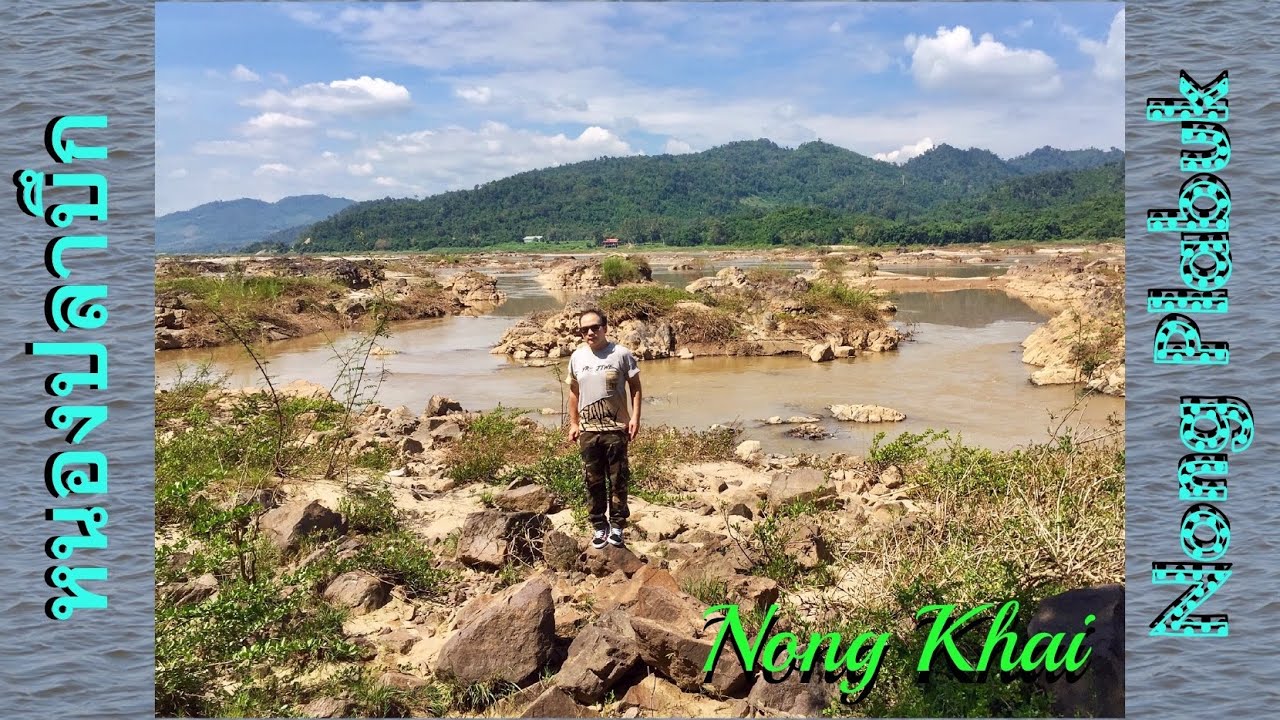
 Click to Access the Navigation Map GPS
Ang Pla Buek Map
Recommend

 Art, Culture and Heritage
 Historical Sites and Monuments(1)
 Landmarks and Memorials(2)
 Art, Craft Centres, Tradition(1)
 Educational Places
 Educational Gardens, Farm(1)
 Places of Worship
 Temple(16)
 Mosque(1)
 Other Sacred Sites(8)
 Suburban Living
 Village, Community(3)
 Local Market(4)
 National Parks and Marine Reserves(2)
 Dam, Reservoir, Lake(2)
 Waterfalls(4)
River, Canal(8)
Waterfalls(4)
River, Canal(8)
 Bays and Beaches(1)
 Entertainment and Agricultural
 Farms, Parks and Ecotourism(2)
 Shopping
 Shopping and Night Market(1)


