
lovethailand home >Northeastern Travel Attractions >Nakhon Phanom Travel Attractions >Muang Nakhon Phanom >Kham Thao > Mekong River
TL;DR: Mekong River is located at Central Mekong Embankment, Sunthorn Wichit Road, Nai Mueang, Mueang Nakhon Phanom, Nakhon Phanom 48000, Thailand, open Daily, hours The public Mekong riverfront is accessible 24 hours a day. Individual.
Mekong River
Open Days: Daily
Opening Hours: The public Mekong riverfront is accessible 24 hours a day. Individual attractions, businesses, markets, and activities operate according to their own schedules.
The Mekong River in Nakhon Phanom Province is an international river of major geographical, historical, economic, ecological, and cultural importance. Along the province, the river forms a natural boundary between Thailand and the Lao People’s Democratic Republic. Nakhon Phanom lies on the Thai bank, while Thakhek and Khammouane Province can be seen across the water. The broad river, distant limestone mountains, historic riverside neighborhoods, religious landmarks, and relaxed urban atmosphere have made the Nakhon Phanom riverfront one of the most distinctive Mekong viewpoints in northeastern Thailand.
Essential information for travelers The public riverfront in central Nakhon Phanom is open daily, 24 hours a day, and no admission fee is charged. The most convenient reference point is the Phaya Si Sattanakharat Plaza on Sunthorn Wichit Road. From this central landmark, visitors can walk beside the river, exercise, cycle, pray at the seven-headed Naga monument, photograph sunrise over Laos, explore the old town, and continue to nearby temples, museums, restaurants, and hotels. During the rainy season, the Mekong rises toward the embankment and carries a strong current. During the dry season, lower water levels reveal sandbanks and long sandy formations, although visitors should not enter these areas without official permission.
The Mekong is a transboundary river beginning in the highlands of the Tibetan Plateau before flowing through China, Myanmar, Thailand, Lao PDR, Cambodia, and Viet Nam. Its journey covers nearly 5,000 kilometres and connects mountain environments, tropical forest, agricultural plains, wetlands, lakes, tributaries, and the Mekong Delta. The river is therefore far more than a line on a map. It is a large living system supporting communities and ecosystems throughout mainland Southeast Asia.
Within Nakhon Phanom Province, the Mekong forms the central element of the landscape. Important communities developed along the river in Mueang Nakhon Phanom, That Phanom, Tha Uthen, and Ban Phaeng districts. Access to the river historically supported travel, fishing, trade, communication, and cultural exchange with settlements on the Lao bank. Food, language, religious traditions, architecture, and local beliefs in Nakhon Phanom continue to reflect this long relationship with the wider Mekong region.
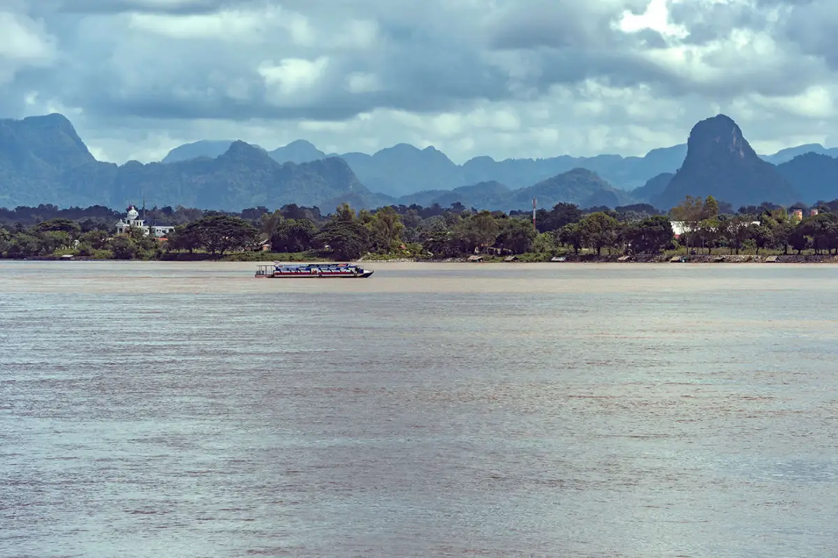
The view toward Laos gives the Nakhon Phanom riverfront its unmistakable character. From Sunthorn Wichit Road, visitors can look across the broad channel toward Thakhek in Khammouane Province. On clear days, the outline of limestone mountains appears above buildings and trees on the opposite bank. During rain or morning mist, the mountains fade into layers of grey, creating a quieter and more atmospheric landscape.
Nakhon Phanom city stands on the western bank of the river, making the promenade an excellent place to watch sunrise over Laos. The first light appears above the distant mountains and forms a golden reflection across the water. Early morning is therefore ideal for walking, running, cycling, photography, or simply sitting beside the river. Travelers planning to photograph sunrise should arrive approximately 20–30 minutes before the expected time to observe the changing sky before the sun appears.
The rainy-season Mekong is shaped by rainfall and runoff throughout both the upper and lower basin. Water from tributaries enters the main channel, raising the river level at Nakhon Phanom. The river may expand toward the embankment, turn naturally brown with suspended sediment, and flow more strongly than during other seasons. This is when the river appears at its most powerful, especially from Phaya Si Sattanakharat Plaza and the central promenade.
The wet season offers dramatic scenery and cooler weather, but visitors must remain aware of river levels and heavy rain. Do not climb over barriers, descend flooded steps, or stand on wet surfaces close to the edge. The Mekong is deep, fast, and uneven, while floating branches and debris can create additional danger. River views should be enjoyed from designated public areas and all municipal or provincial safety notices must be followed.
High-water months are also connected with major local traditions. The most famous is the Illuminated Boat Procession held around the end of Buddhist Lent. Large fire boats are decorated with lights forming religious, cultural, and artistic designs before appearing on the river at night. The festival transforms the normally peaceful promenade into one of the most important gathering places in northeastern Thailand.
The dry-season Mekong has an entirely different appearance. As water levels fall, sandbanks, rocky sections, shallow channels, and parts of the riverbed become visible. Some sandy formations extend for a considerable distance and change shape each year according to the current and sediment movement. The river consequently changes from a channel filled close to its banks into a varied landscape of water, sand, exposed rock, and shallow areas.
The appearance of a sandbank does not automatically make it safe or legal to enter. Some areas lie within an international boundary zone, while apparently firm sand may collapse or conceal mud underneath. Currents can cut through a shallow area quickly, and passing boats may produce waves that return toward the bank. Visitors should remain on the promenade or approved viewing areas and enter a riverbank zone only when local authorities have officially opened it.
The dry season is useful for observing the physical structure of the river. Deep channels, shallows, sediment deposits, and temporary sand formations become easier to distinguish. Birds, fishing boats, and everyday activity can also be observed from the bank. Travelers should avoid disturbing wildlife, touching fishing equipment, or entering working areas used by local fishers.
The cool season beside the Mekong is particularly popular. Nakhon Phanom often experiences comfortable temperatures, and the river breeze makes mornings and evenings feel cooler. From November through February, conditions are well suited to walking, cycling, outdoor dining, and sunrise photography. On some mornings, mist hangs above the river and partially covers the Lao mountains.
A light jacket is useful early in the morning and after dark, especially during December and January. Day and night temperatures may differ significantly, while wind beside the water can make conditions feel cooler than the reported temperature. Layered clothing is practical because it can be removed as the day becomes warmer.
Phaya Si Sattanakharat Plaza is the principal reference point for riverfront travel in central Nakhon Phanom. It stands beside the city embankment near the intersection of Sunthorn Wichit and Nittayo roads. The seven-headed Naga is cast in brass and rises from a coiled body facing the Mekong. It functions as a landmark, viewpoint, public plaza, and place of worship.
The plaza provides space to view the monument, photograph the river, and look toward the mountains of Laos. Morning is best for sunrise, while late afternoon provides cooler air and attractive lighting around the monument. The water feature or illuminated elements may operate according to municipal schedules, so a visit should not depend solely on seeing the Naga fountain in operation.
Naga belief has formed part of Mekong culture for generations. The Naga is associated with water, fertility, protection of Buddhism, and the relationship between human communities and the natural world. The riverside monument is therefore not merely a tourist installation; it expresses the spiritual identity and shared beliefs of the city.
Visitors coming to pray should dress respectfully, place offerings in designated areas, and never discard incense, flowers, candles, or packaging into the river. Worship should not obstruct public movement. During the annual worship festival, parts of the plaza and nearby streets may be reserved for ceremonies, performances, and organized activities.
The Sunthorn Wichit riverside promenade allows visitors to experience the Mekong closely without entering the river. The walkway links landmarks, restaurants, hotels, temples, a Catholic church, museums, and historic neighborhoods. Many sections contain seating, lighting, trees, and areas used for exercise from early morning until evening.
In the morning, travelers can observe residents exercising, buying breakfast, and beginning their daily routines beside the water. The evening atmosphere is busier, with people walking, relaxing, and dining. Parking becomes more difficult on weekends and during festivals, so additional time should be allowed.
The Mekong riverside cycling route is one of the city’s signature activities. The connected route extends for approximately 13 kilometres from the Royal Commemorative Park area through the city toward the Third Thai–Lao Friendship Bridge. Cyclists may choose a short urban section or continue over the complete route according to time and fitness.
Before starting, check the brakes, tire pressure, and bicycle lights. Wear a helmet, remain within the designated route, and reduce speed in crowded pedestrian areas. Morning and evening are more comfortable than midday. During the rainy season, wet pavement, leaves, sediment, and loose sand can reduce traction and increase braking distance.
Rental bicycles should be inspected before use, and the return time and permitted area should be confirmed with the provider. Lock the bicycle securely when stopping and never block a walkway. Groups should keep a safe distance between bicycles and avoid riding side by side when the route is busy.
The Vietnamese Memorial Clock Tower is approximately 0.8 kilometres from Phaya Si Sattanakharat Plaza. It represents the historical connection between Nakhon Phanom and the Vietnamese community that settled in the city. The clock tower stands within the old-town area, where buildings, homes, restaurants, and small businesses reflect a mixture of cultural influences.
The walk from the Naga plaza to the clock tower is short and follows the riverfront environment. Late afternoon is particularly pleasant because temperatures fall and businesses begin evening service. Visitors should use the pavement and official crossings, as motorcycles and cars continue to operate through the old town.
Wat Mahathat and Phra That Nakhon are located close to the riverfront and form an important Buddhist destination. Phra That Nakhon is associated locally with people born on Saturday. A practical urban route can combine the Naga monument, Wat Mahathat, the clock tower, and the walking-street district.
Temple visitors should dress modestly, speak quietly, and avoid disturbing ceremonies. Although the temple is close to a popular tourism district, it remains an active religious site used by the local community. Respectful behavior allows tourism to coexist with everyday religious life.
The Former Nakhon Phanom Governor’s Residence Museum is a historic building beside the Mekong displaying the architectural and administrative history of the city. Its quiet grounds and period structure are particularly interesting for travelers studying local history. Indoor opening days and hours should be checked separately from the 24-hour access to the public riverfront.
The distance between the former residence and the Naga plaza is suitable for walking or cycling. Along the route, the urban landscape changes from the central commercial area toward older administrative and cultural buildings. Reading the interpretation at each site provides a deeper understanding than using the location only as a photography stop.
Saint Anna Nong Saeng Church is an important Catholic church beside the Mekong and reflects the history of the Christian community in Nakhon Phanom. Its architectural character contrasts with the Buddhist temples along the route, adding another dimension to the city’s religious and cultural diversity. Visitors should dress respectfully and avoid entering or photographing worshippers during a service unless invited.
The church grounds also provide views toward the river and Laos. Morning and evening are the most comfortable times for an exterior visit. It lies approximately 2.6 kilometres from Phaya Si Sattanakharat Plaza, making a bicycle, car, or local vehicle more practical than walking during the hottest hours.
The Third Thai–Lao Friendship Bridge connects Nakhon Phanom Province with Khammouane Province. It is an important structure for transportation, trade, and international relations and also forms one end of the long riverside cycling corridor. Anyone crossing the border must use the official checkpoint and comply with immigration, customs, vehicle, and documentation requirements.
Travelers must never attempt to cross the Mekong by private boat or by walking across a sandbank. The opposite bank may appear close, but the river is an international boundary. All cross-border travel must take place through authorized routes.
Mekong River Eye is a newer attraction at the Royal Commemorative Park near the southern end of the city. The observation wheel is approximately 49.5 metres high and contains 28 passenger cabins, providing an elevated view of the river, the urban area, and the mountains of Laos. It is approximately 3 kilometres from the Naga plaza. Operating sessions and admission arrangements should be checked directly with the municipality or operator.
The wheel offers a different understanding of the city from the ground-level promenade. From above, passengers can see the width of the Mekong, the alignment of Sunthorn Wichit Road, and the way Nakhon Phanom has developed along the river. Evening is popular because natural light gradually changes into city illumination, although queues may be longer on holidays.
Walking and running are possible along the public promenade throughout the day. Early morning provides cooler air and less congestion, while evening is more social. Runners should keep to a side that does not obstruct pedestrians, slow down around children and older people, and avoid headphones that completely block surrounding sounds.
During races, ceremonies, or festivals, sections of the road and promenade may be closed or redirected. Visitors must follow staff instructions and remain outside restricted event areas. Public events add energy to the riverfront but require cooperation from all users.
Sunrise photography is one of the most rewarding riverfront activities. Choose an open angle facing Laos and arrive before sunrise. A tripod can be useful but must not obstruct walkers. With a mobile phone, touch the bright sky to set exposure and reduce brightness slightly to preserve the color of the dawn.
After sunrise, the light falls across riverside buildings and the Naga monument, creating another set of photographic opportunities. Photographers should respect the privacy of people exercising or worshipping and should not operate a drone without the permits required by aviation, municipal, and security regulations.
Evening beside the Mekong is defined by cooler air, softer light, and illumination along the urban riverfront. Although the sun sets behind the Thai side of the city rather than directly over the river, changing sky colors still reflect across the water. After dark, visitors can walk around the Naga plaza and dine in the surrounding district.
Weekend evenings often bring heavier parking demand. Vehicles should be left only in approved public areas and must not block homes, businesses, emergency access, cycling lanes, or pavements. Pedestrians should take care when crossing Sunthorn Wichit Road, particularly with children.
Nakhon Phanom Walking Street brings food, crafts, souvenirs, clothing, and local businesses into the old riverside district. Its operating days and hours may be adjusted for festivals or municipal arrangements. Travelers whose visit depends on the market should confirm the current schedule before arrival.
The walking street is a convenient place to taste Isan, Vietnamese-influenced, and local Nakhon Phanom food. Buy only an amount that can be eaten, use the provided waste bins, and never leave containers near the embankment where wind or rain can carry them into the river.
Nakhon Phanom food culture reflects generations of diverse communities living beside the Mekong. Popular breakfasts include Thai-style pan eggs, rice noodle soup, glass-noodle soup, filled bread, and Vietnamese coffee. Lunch and dinner options range from Isan cuisine and Mekong fish to naem nueang, Vietnamese noodles, and conventional Thai dishes.
River fish form part of local cuisine, but species and availability vary with the season and supply. Diners can ask a restaurant about the fish and preparation method. Choosing a clean establishment that stores ingredients correctly is important for safe eating.
Fishing activity remains visible along several parts of the provincial riverbank. Small boats, nets, fishing equipment, and informal landing areas are part of local livelihoods. Visitors should observe from a respectful distance, avoid touching equipment, and stay away from working landing points that are not designed as tourist facilities.
Seasonal water levels influence fishing locations, fish movement, and access to the shore. A sandbank visible during the dry season may disappear completely under high water. Communities adapt their use of the river according to these natural changes.
The Mekong ecosystem supports a high diversity of fish, aquatic animals, plants, birds, and smaller organisms. Connections between the main channel, tributaries, wetlands, and seasonally flooded areas provide habitats for feeding, breeding, and migration. Changes in water quality, current, sediment, and seasonal timing can therefore affect a much larger ecological system.
Visitors can reduce their impact by removing waste, never pouring food or drinks into the river, and limiting single-use plastic. Litter dropped on the promenade can be carried into the Mekong by wind or rain and travel far beyond the original location.
Riverfront safety remains important even when the water appears calm. Do not sit on barriers, climb down an embankment, or stand on wet surfaces beside the edge. Children should remain on the inner side of the walkway under continuous adult supervision. Anyone affected by alcohol should stay away from the water and must not drive.
The Mekong contains deep channels and strong currents that cannot be judged from the surface. Swimming outside an officially managed safe area is highly dangerous. Never jump from an embankment, pier, stairway, or structure, even during the dry season when part of the channel appears shallow.
High-water conditions require attention to provincial and municipal warnings. When river levels approach a safety threshold, lower walkways, steps, parking areas, or river-access points may close. Visitors must not cross barriers for photographs.
After the river falls, mud, sediment, algae, branches, and sharp debris may remain. Wait until the responsible authority has cleaned and reopened the area. Descending immediately after floodwater recedes presents risks from both slippery surfaces and hidden objects.
Hot-season precautions are necessary despite the river breeze. Midday temperatures can become high and some sections of the route have limited shade. Carry water, use sunscreen, wear a hat, and avoid strenuous exercise from approximately 11:00 to 15:00. Stop in the shade if dizziness, headache, weakness, or nausea develops.
Concrete and exposed sand can become extremely hot. Young children and pets should not remain on heated surfaces. Pets should be controlled on a lead, waste must be collected, and separate attraction rules should be checked before bringing an animal inside.
What to bring includes comfortable walking shoes, a hat, drinking water, sunscreen, a compact rain jacket or umbrella, personal medication, and a small bag for personal waste. Cool-season sunrise visitors should carry a light jacket. Cyclists should use a helmet, front and rear lights, and basic repair equipment.
A phone should be fully charged, and an offline map is useful when cycling far from the city center. Constant photography and navigation can drain a battery quickly. A power bank helps maintain communication and map access throughout the day.
A morning itinerary can begin before sunrise at Phaya Si Sattanakharat Plaza. After watching the light appear above Laos, walk or cycle to the Vietnamese Memorial Clock Tower, eat breakfast in the city, and continue to the Former Governor’s Residence Museum or Saint Anna Nong Saeng Church.
This plan is especially suitable during the cool season or on a clear day. Museum and religious-site opening times must be checked independently because the 24-hour riverfront access does not apply to the interior of every building.
An evening itinerary can begin at approximately 16:30 at the Naga plaza. Walk beside the river, photograph the monument, and continue to the clock tower. When the walking street is operating, stop for local food and souvenirs before returning to enjoy the illuminated riverfront.
Mekong River Eye may be planned for a separate evening or reached by vehicle after the central promenade. Because the attraction operates by scheduled sessions, sufficient time should be allowed for travel and queuing.
A full-day itinerary may combine sunrise, breakfast, Wat Mahathat, the Vietnamese Memorial Clock Tower, and the Former Governor’s Residence Museum. After lunch, continue to Saint Anna Nong Saeng Church or the Third Thai–Lao Friendship Bridge before returning to the central riverfront in the evening.
A schedule should not be so crowded that no time remains to rest. Nakhon Phanom is best understood at a slower pace through sitting beside the river, speaking with local people, and observing architecture and daily life rather than rushing between landmarks.
Travel from Nakhon Phanom Airport to Phaya Si Sattanakharat Plaza covers approximately 18–20 kilometres and normally takes 25–35 minutes. Available options include a rental car, airport taxi, or hotel transfer. Confirm the destination and price before leaving when using a hired vehicle.
Rental-car users should check fuel, insurance, and return conditions. The road into central Nakhon Phanom is straightforward, but speed should be reduced in populated areas and attention given to motorcycles. Entering the Naga monument or a nearby hotel into a navigation system provides direct access to the riverfront district.
Travel by interprovincial bus brings passengers to Nakhon Phanom Bus Terminal. A local taxi or app-based service is then required for the final journey to Sunthorn Wichit Road. Keeping the Thai name “ลานพญาศรีสัตตนาคราช” available on a phone helps the driver identify the exact destination.
Road travelers from Sakon Nakhon, Mukdahan, Bueng Kan, or Nong Khai can enter the province by several routes. Accommodation should be reserved early during the Illuminated Boat Procession, Naga worship festival, and major public holidays, when traffic and demand increase considerably.
Travel by private car is convenient, but parking must be limited to legal roadside spaces or designated public lots. Do not park on a bicycle lane, pavement, residential entrance, business access, or emergency route. During major events, using an outer parking area and walking into the riverfront is often easier.
Hotels close to the Naga plaza allow visitors to reach the river on foot for both sunrise and evening activities. Properties farther north or south may provide wider grounds and different river views while requiring a short drive into the historic center.
Facilities along the central riverfront include paved walkways, lighting, seating, cycling space, parking, restaurants, cafés, hotels, and toilets within selected businesses or attractions. Facilities are not distributed evenly throughout the full 13-kilometre cycling corridor, so long-distance cyclists should carry water and identify rest points in advance.
The Naga plaza and old town contain a higher concentration of services than sections closer to the Friendship Bridge. Families and older visitors can remain within the central zone, where distances are shorter, although uneven surfaces and road crossings still require care.
Accessibility varies along the promenade. Several principal sections are relatively level, while others include steps, ramps, curbs, or changes in surface. Wheelchair users may require assistance and should avoid peak festival crowds. Parking close to the selected attraction and arriving in the morning can reduce heat and walking distance.
Accessible toilets may be available only in particular attractions, hotels, restaurants, or municipal facilities. Travelers with specific requirements should confirm availability beforehand and carry medication, water, and basic health information.
Riverfront etiquette involves sharing the walkway, keeping noise moderate, and avoiding objects that obstruct movement. Exercise activities should respect worshippers and people resting, while ceremonies and offerings should remain within designated areas rather than occupying the entire walkway.
Lanterns, floating objects, and worship materials should not be released into the Mekong without an authorized event. Expressions of faith can be carried out at the prepared site, with every material removed and disposed of correctly.
Waste reduction is especially important in a riverside city. Reusable bottles, cloth bags, and personal containers can reduce disposable packaging. Waste should be separated when appropriate and never left beside an overflowing bin, where wind may carry it into the water.
Cigarette filters are small but contain persistent waste. Smoking should be avoided in crowded public spaces, and filters must never be dropped on the pavement. Use only an appropriate smoking location and extinguish the cigarette completely.
Respecting the international border is essential. General landscape photography is normally possible from public areas, but security personnel, border operations, or restricted facilities should not be photographed in a disruptive manner. Boat trips and cross-border travel must use authorized operators and checkpoints.
A drone must not be flown across the river or international boundary. Drone operation is subject to aviation law, security requirements, and local permission. Crossing into another country’s airspace without authorization can result in serious legal consequences.
The annual Phaya Si Sattanakharat worship festival takes place beside the Mekong during July and includes religious ceremonies and cultural performances. In 2026, the principal event period was 7–13 July. Dates and programs should always be checked for the year of travel.
Road closures, ceremonial zones, and restricted parking may operate during the festival. Arrive early, wear comfortable shoes, follow staff instructions, and place offerings only in approved areas.
The Illuminated Boat Procession is another period when the river becomes the focus of provincial life. Boats from different districts are decorated with lights and cultural designs before appearing on the Mekong during the end-of-Buddhist-Lent period. Riverside accommodation fills rapidly and should be booked well in advance.
Festival visitors should remain at managed viewing areas and never climb barriers for a photograph. Carry rain protection and water, and agree on a meeting point because mobile networks may become congested. Walking back to a nearby hotel is often easier than attempting to drive immediately after the event.
The Mekong and Nakhon Phanom identity are inseparable. The river influences the layout of streets, food, festivals, religious beliefs, trade, and everyday life. Morning exercise, breakfast shops, fishing boats, riverside worship, and lights from Laos after dark show that the Mekong is part of the living city rather than simply a scenic background.
A short riverfront journey reveals remarkable cultural diversity: Buddhist temples, Naga belief, Vietnamese heritage, a Catholic church, historic government architecture, an international bridge, and a modern observation wheel. Together they demonstrate how Nakhon Phanom developed through continuous contact between communities on both banks.
Reasons to visit the Mekong in Nakhon Phanom include scenery that changes by hour and season. Sunrise appears over Lao mountains, the river dominates the daytime landscape, evening brings comfortable walking conditions, and night reveals lights on both banks. The rainy season fills the channel, the cool season brings fresh air, and the hot season reveals sandbanks and exposed river formations.
The destination suits nature lovers, photographers, cyclists, food travelers, families, history enthusiasts, and anyone seeking a slower journey. A visitor can spend one hour at the Naga plaza or remain for several nights to explore riverfront communities throughout the province.
Getting There The most convenient starting point is Phaya Si Sattanakharat Plaza on Sunthorn Wichit Road in central Nakhon Phanom. It is approximately 18–20 kilometres from Nakhon Phanom Airport and takes around 25–35 minutes by car. From the bus terminal, use a local taxi or app-based vehicle. Drivers should navigate to the Naga plaza and park only in an approved area.
Once at the riverfront, the central attractions can be explored on foot or by bicycle, while a car is useful for more distant locations. The Vietnamese Memorial Clock Tower is approximately 0.8 kilometres from the Naga plaza, the Former Governor’s Residence Museum approximately 1.3 kilometres, Saint Anna Nong Saeng Church approximately 2.6 kilometres, and Mekong River Eye approximately 3 kilometres.
The Mekong River in Nakhon Phanom is simultaneously a natural border, cultural connection, ecological system, livelihood, and public space. Observing safety regulations, respecting international boundaries, removing waste, and supporting local businesses allow tourism to benefit both travelers and the communities that continue to live beside this great river.
| Name | Mekong River, Nakhon Phanom, and the Central Nakhon Phanom Riverfront |
| Main Reference Point | Phaya Si Sattanakharat Plaza, Sunthorn Wichit Road, Nai Mueang, Mueang Nakhon Phanom, Thailand |
| Address | Central Mekong Embankment, Sunthorn Wichit Road, Nai Mueang, Mueang Nakhon Phanom, Nakhon Phanom 48000, Thailand |
| Reference Coordinates | 17.3994, 104.7906 |
| Key Characteristic | An international river forming the natural border between Thailand and Lao PDR, with Thakhek and Khammouane Province opposite central Nakhon Phanom |
| Highlights | Sunrise over Laos, riverside walking and cycling, the seven-headed Naga monument, historic neighborhoods, high rainy-season water, and exposed dry-season sandbanks |
| Importance | International waterway, border landscape, fishing resource, ecological system, tourism area, and foundation of Mekong cultural identity in Nakhon Phanom |
| Best Travel Period | Accessible throughout the year. November–February offers cooler weather; the rainy season brings high water; and the dry season reveals sandbanks and exposed river formations. |
| Open Days | Daily |
| Opening Hours | Public riverfront areas are accessible 24 hours a day. Buildings, businesses, markets, and individual attractions have separate operating hours. |
| Admission Fee | No fee for the public riverfront. Individual attractions and activities may charge separately. |
| Main Areas / Zones | 1. Phaya Si Sattanakharat Plaza and central embankment 2. Sunthorn Wichit walking and cycling corridor 3. Vietnamese Memorial Clock Tower and old town 4. Wat Mahathat and Phra That Nakhon 5. Former Governor’s Residence Museum 6. Saint Anna Nong Saeng Church 7. Royal Commemorative Park and Mekong River Eye 8. Extended cycling route toward the Third Thai–Lao Friendship Bridge |
| Activities | Sunrise viewing, walking, running, cycling, photography, Naga worship, old-town exploration, riverside dining, and seasonal cultural festivals |
| Facilities | Walkways, lighting, seating, cycling space, parking, restaurants, cafés, hotels, and toilets at selected businesses or attractions |
| Travel Information | Approximately 18–20 km from Nakhon Phanom Airport, taking around 25–35 minutes. From the bus terminal, use a local taxi or navigate to Phaya Si Sattanakharat Plaza. |
| Current Status | Open as the principal public riverfront and tourism district of Nakhon Phanom city. Individual sections may close temporarily during high water, festivals, maintenance, or public-safety operations. |
| Caretaker | Public areas in the municipal riverfront zone are managed by Nakhon Phanom Municipality in cooperation with Nakhon Phanom Province and government agencies responsible for navigation, borders, and public safety. |
| Main Contact Number | Nakhon Phanom Municipality: 042-512-005 |
| Official Information | Nakhon Phanom Municipality, Nakhon Phanom Provincial Office, and Tourism Authority of Thailand |
| Safety | Do not climb barriers, swim in the general river channel, enter sandbanks without authorization, or cross the international border outside an official checkpoint. |
| Nearby Tourist Attractions | 1. Phaya Si Sattanakharat Plaza, 0 km, Municipality Tel. 042-512-005 2. Vietnamese Memorial Clock Tower, 0.8 km 3. Wat Mahathat and Phra That Nakhon, 0.9 km 4. Former Nakhon Phanom Governor’s Residence Museum, 1.3 km 5. Saint Anna Nong Saeng Church, 2.6 km, Tel. 042-516-050 6. Mekong River Eye, 3 km, Municipality Tel. 042-512-005 |
| Nearby Restaurants | 1. Cafe Le Landmark, 0.1 km, Tel. 091-006-8246 2. Phonthep Breakfast Restaurant Branch 1, 0.5 km, Tel. 042-511-593 3. Nang Naem Nueang, 0.8 km, Tel. 042-512-424, 042-514-322 4. Sabaidee Nakhon Phanom, 1.2 km, Tel. 042-064-200 5. Ruean Rim Nam Mekong Restaurant, 2.5 km, Tel. 082-107-7241, 088-680-7609 |
| Nearby Accommodations | 1. Landmark Nakhon Phanom Hotel, 0.1 km, Tel. 091-740-3001 2. Fortune River View Hotel Nakhon Phanom, 2.2 km, Tel. 042-522-334 3. The River Hotel Nakhon Phanom, 3.2 km, Tel. 083-669-2999, 042-522-999 4. Hotel VELA Dhi Nakhon Phanom, 3.5 km, Tel. 042-515-919 5. Blu Hotel Nakhon Phanom, 6 km, Tel. 063-958-4403, 065-998-1811 |
Frequently Asked Questions (FAQ)
Q: Where is the Mekong River in Nakhon Phanom?
A: The Mekong flows along the eastern side of Nakhon Phanom Province and forms the border between Thailand and Lao PDR. The most convenient central viewpoint is Phaya Si Sattanakharat Plaza on Sunthorn Wichit Road.
Q: What are the opening hours and admission fee for the Nakhon Phanom riverfront?
A: The public riverfront is accessible daily, 24 hours a day, and no admission fee is charged. Individual buildings, attractions, markets, restaurants, and Mekong River Eye have their own hours and charges.
Q: When is the best time to visit the Mekong in Nakhon Phanom?
A: The riverfront is attractive throughout the year. November–February offers comfortable walking and cycling weather, the rainy season brings high water, and the dry season reveals sandbanks and exposed river formations.
Q: Where is the best place to watch sunrise?
A: Phaya Si Sattanakharat Plaza and the Sunthorn Wichit promenade provide clear east-facing views toward Thakhek and the mountains of Khammouane Province in Laos.
Q: Can travelers walk onto the sandbanks during the dry season?
A: Travelers should not enter a sandbank without official authorization. Sand may collapse or conceal mud, water levels can change quickly, and parts of the river form an international boundary zone.
Q: What activities are available beside the Mekong?
A: Popular activities include walking, running, cycling, sunrise photography, worship at the Naga monument, exploring the old town, dining beside the river, riding Mekong River Eye, and attending seasonal festivals.
Q: Can visitors swim across the river or take a private boat to Laos?
A: No. Swimming in the general channel is dangerous, and international travel must take place through an authorized border checkpoint such as the Third Thai–Lao Friendship Bridge.
Q: How do travelers reach the riverfront from Nakhon Phanom Airport?
A: Phaya Si Sattanakharat Plaza is approximately 18–20 kilometres from the airport and normally takes 25–35 minutes by rental car, airport taxi, or hotel transfer.
 Category: ●Nature and Wildlife
 Group: ●River, Canal
Last Update : 3 MonthAgo
 Last Update : 3 MonthAgo
 Click to Access the Navigation Map GPS
Mekong River Map
Gellery
Recommend

 Art, Culture and Heritage
 Historical Sites and Monuments(3)
 Landmarks and Memorials(2)
 Art, Craft Centres, Tradition(3)
 Museums(3)
 Educational Places
 Library(1)
 Places of Worship
 Temple(23)
 Church(1)
 Other Sacred Sites(11)
 Suburban Living
 Village, Community(5)
 National Parks and Marine Reserves(1)
 Dam, Reservoir, Lake(5)
 Waterfalls(2)
River, Canal(3)
Waterfalls(2)
River, Canal(3)
 Bays and Beaches(3)
 Other natural attractions(2)
 Entertainment and Agricultural
 Zoos and Aquariums(1)
 Farms, Parks and Ecotourism(2)
 Shopping
 Shopping and Night Market(1)
 Travel Articles, Recipes
 Travel Review, Food Review(1)


