
lovethailand home >Northeastern Travel Attractions >Nakhon Phanom Travel Attractions >Tha Uthen >Phanom > Ban Phanom Dinosaur Footprints
TL;DR: Ban Phanom Dinosaur Footprints is located at Ban Phanom, Village No. 2, Phanom Subdistrict, Tha Uthen District, Nakhon Phanom Province, open Daily, hours 08:00–17:00.

Ban Phanom Dinosaur Footprints
Open Days: Daily
Opening Hours: 08:00–17:00
Ban Phanom Dinosaur Footprints, officially promoted as the Tha Uthen Dinosaur Footprint Learning Site, is one of Thailand's most important fossil track localities. The site is situated at Ban Phanom, Village No. 2, Phanom Subdistrict, Tha Uthen District, Nakhon Phanom Province, beside Highway 212 on the Nakhon Phanom–Ban Phaeng route at kilometre 257. Its principal attractions are hundreds of footprints and multiple trackways preserved in rocks of the Khok Kruat Formation since the Early Cretaceous, approximately 100 million years ago.
The marks visible on the reddish rock surface are more than isolated impressions. They form an extensive record of prehistoric animals moving across a riverbank. Small theropod dinosaurs walked in groups across moist sediment, plant-eating dinosaurs passed through the same landscape, and ancient crocodyliforms moved beside shallow channels. The direction, spacing, depth, and shape of the tracks allow palaeontologists to investigate body size, walking speed, changes in direction, slipping, and possible herd behaviour.
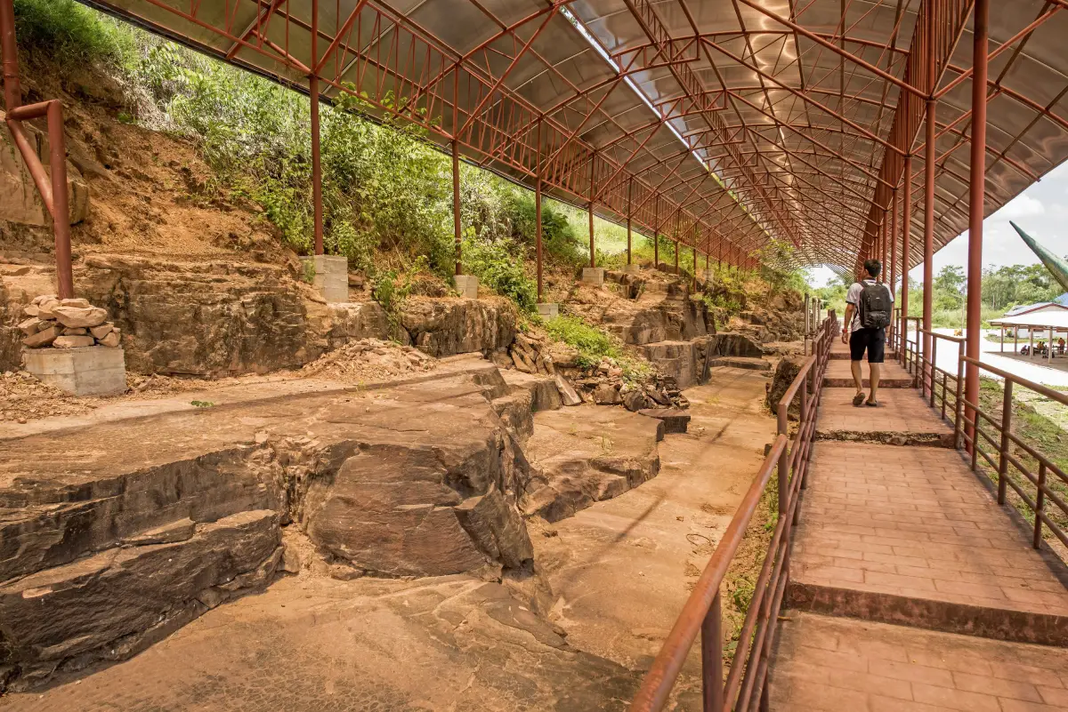
Visitors can observe authentic tracks beneath protective roofing, using designated walkways and viewing areas that prevent direct pressure on the fossil-bearing rock. Interpretive signs explain the geological setting, fossilisation process, types of trackmakers, and prehistoric environment. Dinosaur models provide an accessible introduction for children and visitors without a scientific background. The learning site is open free of charge every day from 08:00 to 17:00 and provides parking and toilets.
The locality is known by several names. Thai sources use Ban Phanom Dinosaur Footprints, Tha Uthen Dinosaur Footprint Learning Site, Tha Uthen Dinosaur Tracksite, and Huai Dan Chum Dinosaur Footprints. International scientific papers generally refer to it as the Huai Dan Chum Tracksite. These names identify the same fossil locality in Phanom Subdistrict, although spelling and transliteration can differ among maps, government documents, and academic publications.
Approximately 100 million years ago, northeastern Thailand looked very different from the landscape seen today. The region formed part of a broad continental basin crossed by several river systems. Water flowed from the northeast toward the central basin before draining westward. The environment included river channels, floodplains, sandbanks, temporary ponds, and low-lying areas repeatedly covered by sediment.
The climate was relatively hot and seasonally dry. Rainy intervals alternated with extended dry periods. Sand, silt, and mud deposited by rivers and floodwaters underwent oxidation, particularly involving iron-bearing minerals. This process produced the characteristic red, reddish-brown, and purplish-red colours of the rocks. The colour therefore records ancient climatic and chemical conditions rather than any modern treatment of the stone.
During the rainy season, water spread across the floodplain and flowed from higher ground into streams and larger rivers. Moving water created ripple marks on the surface of sand and mud. These small ridges and troughs preserve evidence of current direction and water energy. As the water receded, exposed mud dried and contracted, forming polygonal mud cracks. Both ripple marks and mud cracks can still be observed in association with the fossil tracks.
These sedimentary structures are as valuable as the footprints themselves because they explain the surface on which the animals walked. Tracks associated with ripple marks indicate a shallow riverside or channel-margin setting. Mud cracks show that the ground later emerged from the water and dried before another layer of sediment covered it. Together, the features reconstruct a landscape that repeatedly changed between wet and dry conditions.
Although the wider climate was seasonally dry, river basins concentrated water, vegetation, and food. Herbivorous dinosaurs could feed on plants growing near the channels, while small predatory dinosaurs crossed open areas or followed other animals. Ancient crocodyliforms occupied waterways and muddy banks. Fish, turtles, and other vertebrates shared the same freshwater ecosystem. The density and diversity of tracks reveal a productive habitat rather than an empty desert.
When ostrich-like dinosaurs and other animals crossed the riverbank, the sand or mud was moist enough to receive their weight but firm enough to retain a recognisable outline. If the surface had been too wet, the impressions would have collapsed. If it had been completely dry and hard, the feet would have left little trace. The preservation of so many tracks indicates an unusually favourable combination of moisture, sediment grain size, drying, and rapid burial.
Footprint fossilisation began when an animal pressed its foot into soft sediment. The newly formed impression then had to survive water movement, wind, and later animals walking across the same surface. Sunlight may have dried and strengthened the upper layer. Fine sand, silt, or mud subsequently covered the track, protecting it from erosion.
As additional sediment accumulated, the lower layers were compacted. Water was expelled from pore spaces, and minerals cemented grains together until the sediment became rock. Millions of years later, crustal movement uplifted the strata. Natural erosion and quarrying removed the overlying rock, exposing the surface on which the animals had walked approximately 100 million years earlier.
Fossil tracks can occur as two basic forms. A true impression or mould is a concave depression created directly by the animal's foot. A natural cast forms when younger sediment fills the original impression and later hardens. If the layers separate, the infill appears as a raised replica of the foot. Distinguishing moulds from casts is important when interpreting anatomy and direction of travel.
The footprint-bearing rocks belong to the Khok Kruat Formation, the upper part of the Khorat Group. They date from the late Early Cretaceous, particularly the Aptian–Albian interval, approximately 100–113 million years ago. The formation includes reddish-brown sandstone, siltstone, mudstone, and other continental sediments deposited mainly by rivers. Equivalent or related red-bed sequences extend across parts of northeastern Thailand, Laos, and Cambodia.
The Ban Phanom locality was originally a sandstone quarry. Rock extracted from the area was used for construction and for strengthening the banks of the Mekong River and its tributaries. Quarrying removed the overlying material and revealed the fossil-bearing surfaces. At the same time, early blasting and movement of large sandstone blocks damaged or displaced some tracks before their scientific importance was fully recognised.
Accounts of the discovery vary slightly. Evidence was first noticed and reported around 2001–2002, before geologists from Thailand's Department of Mineral Resources conducted systematic investigations in 2002. The initial survey identified numerous three-toed, bird-like impressions on red sandstone, together with fossil-bearing blocks separated from the original rock layer. Slender toes with pointed ends indicated bipedal animals with claws.
An early investigation documented approximately 199 footprints forming about 72 trackways within an exposed area of roughly 30 square metres. This figure became widely repeated on signs and tourism pages. Later excavation and research examined a larger surface and identified many additional tracks. Modern studies report approximately 600 tracks across the Huai Dan Chum locality, while the principal western slab alone contains more than 450 recognisable tracks and over 50 theropod trackways.
The difference between 199 and approximately 600 tracks does not necessarily represent a contradiction. The smaller number refers to a limited area recorded during an early phase of investigation. The larger total reflects later excavation, broader mapping, and more detailed counting. Presenting both figures explains how scientific knowledge developed as more of the site became accessible.
Most tracks were made by small theropod dinosaurs. Theropods generally walked on two hind limbs and possessed three principal weight-bearing toes. Many species were predatory, although the group included animals with varied diets. The small tracks at Huai Dan Chum are commonly referred to the ichnogenus Asianopodus. Researchers have proposed that the trackmakers were probably ornithomimosaurs, popularly described as ostrich-like dinosaurs.
The term “ostrich dinosaur” is a convenient visual comparison rather than a claim that these animals were modern ostriches. Ornithomimosaurs typically had long hind limbs, relatively lightweight bodies, elongated necks, and adaptations for rapid movement. Identifying an exact dinosaur species from tracks alone remains difficult because several animals can have similar feet, while wetness, depth, slipping, and erosion can alter the final shape of an impression.
Well-preserved theropod tracks normally show a forward-pointing central toe and two spreading lateral toes. The ends may be narrow and pointed where claws entered the sediment. Some impressions at Ban Phanom are shallow and slender; others are deeper, wider, or distorted. Track length and width provide an indication of foot size, while step length and the distance between left and right impressions can be used to estimate hip height and movement speed.
The presence of many similarly sized tracks travelling in comparable directions provides evidence of group movement. Several small dinosaurs probably crossed the surface within a relatively short period. They may have travelled together while searching for food, avoiding predators, or following a riverside route. The surface could nevertheless have remained exposed for hours or days, so not every footprint was necessarily made at exactly the same moment.
Intersecting trackways demonstrate that the site was not a simple one-direction trail. Some animals moved left, others right, and certain sequences appear to accelerate, turn, or slip. A change in direction might reflect an obstacle, a channel, another animal, or the search for food. Such behavioural information is rarely available from fossil bones alone.
The site also contains a trackway made by a plant-eating ornithopod dinosaur. Scientific descriptions compare it with the ichnogenus Caririchnium. Older tourism material often referred to this type of trackmaker as an iguanodont. Ornithopod is the broader and more scientifically appropriate term for the group of herbivorous dinosaurs represented by this trackway.
A particularly significant component of the assemblage is the presence of crocodyliform trackways. Surveys recognised at least 15 trackways produced by ancient crocodile relatives. Some preserve sequences of small forefoot and hind-foot impressions, and several have been referred to the ichnofamily Batrachopodidae. Their presence confirms that the track surface lay beside active water channels and supported aquatic or semi-aquatic reptiles.
Early interpretive material sometimes mentioned possible sauropod footprints because several large impressions were initially associated with long-necked dinosaurs. Later detailed studies of the principal slabs have focused primarily on small theropod, ornithopod, and crocodyliform tracks. Visitors may therefore encounter slightly different classifications on older and newer sources. This reflects the normal revision of scientific interpretations as better mapping and comparative evidence become available.
Footprints provide a different type of information from fossil bones. Bones reveal skeletal structure, evolutionary relationships, and aspects of anatomy. A track records a living animal in motion. A single impression shows the shape of a foot, while a sequence reveals direction, stride, pace, and sometimes interaction with other animals. Hundreds of tracks on one surface create an unusually detailed snapshot of an ancient riverside community.
Huai Dan Chum is regarded as one of Thailand's most important vertebrate tracksites because of the number, density, preservation, and diversity of its traces. Small theropod tracks occur together with an ornithopod trackway, crocodyliform tracks, ripple marks, and mud cracks. Researchers can therefore investigate both animal behaviour and the environment in which the animals moved.
The locality was officially registered as a protected fossil site in 2011 under Thailand's Fossil Protection Act. Registration helps prevent unauthorised excavation, blasting, removal, and destruction. Fossil-bearing rocks are not souvenirs. Even a loose fragment may preserve geological context, and removing it from the site can destroy information about its relationship with the surrounding layer.
Before protection measures were introduced, quarry blasting and stone removal affected parts of the fossil surface. Local accounts and early interpretive material suggest that more than 1,000 impressions may originally have been visible, although the total cannot now be independently reconstructed. The history demonstrates how quickly an irreplaceable fossil locality can be damaged if scientific assessment and legal protection arrive too late.
The Department of Mineral Resources and partner organisations surveyed the quarry, mapped tracks, exposed additional surfaces, and introduced conservation measures. Important work in 2007 and 2008 included constructing roofs above the main outcrops and installing interpretive displays. Roofing reduces direct rainfall and weathering, while walkways and barriers prevent visitors from stepping on the fossil surface.
The site is currently managed locally by the Phanom Subdistrict Administrative Organisation, in coordination with geological authorities, provincial agencies, researchers, schools, and the surrounding community. The current chief executive of the local organisation is Apichat Dibukkham. Effective management requires both visitor services and specialist monitoring of the protected rock surfaces.
The entrance area contains the site sign, access route, and parking. Visitors should use the designated parking space rather than stopping on the shoulder of Highway 212. The highway carries fast-moving traffic between Nakhon Phanom, Tha Uthen, and Ban Phaeng, so drivers should reduce speed well before the entrance and supervise children near the road.
An interpretation area introduces the age of the rocks, fossilisation, dinosaur groups, and ancient river environment. Reading these explanations before viewing the main slabs makes it easier to distinguish genuine tracks from fractures, weathered holes, or irregularities in the stone. It also explains why apparently minor features such as ripple marks are scientifically important.
The principal conservation area lies beneath protective roofing. It preserves the most important track-bearing surface and multiple overlapping trackways. Visitors must remain on the designated walkway and behind barriers. Although the rock appears solid, repeated pressure, shoe abrasion, dust, moisture, and accidental impacts can gradually wear away fine details along the toes and track margins.
The walkway allows the slabs to be viewed from several angles. Directional light is essential because some tracks are shallow. When sunlight or artificial light falls obliquely, shadows make the toe margins easier to recognise. Visitors who cannot immediately identify a footprint should look from the side and search for a repeating left-right sequence rather than concentrating on an isolated depression.
Another learning area focuses on the rock itself. Visitors can observe sandstone, siltstone, mudstone, ripple marks, mud cracks, and variations in sediment texture. These features connect the animal tracks with water movement, drying, and burial. Concentrating only on the most obvious footprints would overlook much of the evidence explaining why the tracks formed and survived.
Dinosaur models and photographic areas make the site engaging for younger visitors. The models should be understood as interpretive reconstructions rather than fossils. Body shape, skin covering, and colour are based on scientific knowledge and artistic interpretation available when the models were created. Such reconstructions can change as new research modifies our understanding of dinosaur appearance.
Facilities include parking, toilets, protective roofing, viewing paths, railings, interpretive signs, models, and rest areas. The locality is outside the main urban centre and does not contain a large restaurant or convenience store. Visitors should carry drinking water, medication, and other essentials, especially when travelling with children, elderly relatives, or a school group.
To identify a theropod track, begin by looking for three toes. The middle toe normally points forward and is longer than the two lateral toes. Once one impression is located, look ahead for the next at a similar distance. Alternating left and right tracks form the walking sequence. An isolated hollow without clear toes may be an eroded track, another type of impression, or a natural feature.
Visitors must not pour water on the tracks to darken them for photographs. Chalk, pens, powder, or other materials must never be used to outline an impression. Coins and personal objects should not be placed inside the tracks. Moisture, chemicals, and abrasion can accelerate deterioration. Adjusting the camera angle or using side lighting provides a safer way to reveal details.
Photography is most informative when it includes both wide views and close details. A wide image shows the direction and relationship of trackways, while a closer image records toe shape and preservation. A scale object can be placed on the visitor walkway beside the fossil area, but not directly on the protected rock. Tripods should not block circulation or press against fossil-bearing surfaces.
Families can use the locality as an outdoor classroom. Children can learn that fossils include traces of activity, not only bones. Counting toes, comparing footprint sizes, following track directions, and searching for ripple marks create educational activities without touching the specimens. Adults should explain that the barriers protect evidence which cannot be replaced once damaged.
For schools and universities, the site supports lessons in geology, palaeontology, sedimentology, environmental science, evolution, and natural heritage conservation. Teachers can connect rock formation, the water cycle, river deposition, animal classification, and protected-area management in one location. Large groups should contact the Phanom Subdistrict Administrative Organisation before travelling.
Elderly visitors and people with reduced mobility should inspect walkway conditions before entering. The locality originated as a quarry and includes some uneven surfaces and changes in level. Assistance may be useful on ramps or rough sections. Closed shoes with good traction are preferable to high heels or smooth-soled footwear.
Morning is generally the best time to visit. Temperatures are lower, and angled light helps reveal shallow tracks. Afternoon visits are possible, but the surrounding area can become hot during the late dry season and summer. Although the principal slabs are roofed, visitors still cross open ground and should carry water, wear a hat, and use sun protection.
The rainy season brings greener surroundings and milder temperatures, but paths can become wet or slippery. Visitors should avoid sections of the former quarry that are not officially open. Water may collect in lower ground after heavy rain. Safety signs and local instructions should always be followed.
A general visit takes approximately 45–90 minutes. Travellers who read the displays carefully and examine multiple trackways may spend about 2 hours. The site works well as a stop on the Nakhon Phanom–Tha Uthen–Ban Phaeng route or as part of a half-day or full-day itinerary covering Phanom, Chai Buri, and Tha Uthen.
Getting There from central Nakhon Phanom is straightforward. Follow Highway 212 north toward Tha Uthen and Ban Phaeng. Continue beyond Tha Uthen until kilometre 257 in Phanom Subdistrict, where signs identify the dinosaur footprint learning site beside the highway. The distance from Nakhon Phanom city is approximately 53 km, normally requiring 50–70 minutes by private vehicle depending on traffic.
From Tha Uthen town, continue north on Highway 212 toward Ban Phaeng for approximately 27–29 km. Travellers approaching from Ban Phaeng use the same highway southbound toward Tha Uthen. The site is beside the main road and does not require a long unpaved or mountain route, but drivers should slow down while approaching the entrance.
Travellers arriving at Nakhon Phanom Airport can rent a car or hire a driver and connect with Highway 212. Scheduled public transport stopping directly at the learning site is limited, making a private vehicle or hired car the most convenient option. Anyone using a bus along Highway 212 should confirm in advance whether the driver can stop near kilometre 257 and should arrange a reliable return journey.
Parking is available inside the site. Drivers should enter and leave cautiously because the access point connects with a high-speed road. Vehicles should not be left on the roadside when spaces remain available inside. School buses and large tour vehicles should contact the local authority before arrival to confirm turning and parking arrangements.
A half-day itinerary can begin at the Ban Phanom footprints in the morning, continue to a local lychee-growing area and Wat Phutthanimit, and finish with lunch near the confluence of the Songkhram and Mekong rivers at Chai Buri. The route links the prehistoric river environment with the modern agricultural and riverside life of Tha Uthen District.
A full-day journey can continue to Wat Phra That Tha Uthen, the historic centre of Tha Uthen, Wat Traiphum, and the Mekong riverfront. This route moves from the age of dinosaurs to local religious history, Tai Yo culture, traditional settlement, and contemporary life beside the Mekong in a single day.
Wat Phutthanimit is approximately 4 km from the tracksite and provides a convenient cultural stop. A nearby large-scale Nakhon Phanom lychee-growing area introduces visitors to an important local crop. Orchard access and fruit-picking activities depend on the season, so travellers should confirm availability with the community before visiting.
The Song Si River Confluence viewpoint at Chai Buri is approximately 10 km away. Here, the Songkhram River meets the Mekong, creating a landscape shaped by two major waterways. Water colour and flow patterns vary with season and rainfall. Restaurants and accommodation around Chai Buri make the confluence a practical lunch or overnight stop.
Wat Phra That Tha Uthen lies approximately 29 km from the dinosaur footprint site. It is one of the district's principal religious landmarks and a centre of faith for communities on both sides of the Mekong. Nearby are the old town, local cafés, markets, traditional temples, and the riverside promenade.
Dining choices immediately beside the fossil site are limited. Many of the most suitable options are in Chai Buri and Tha Uthen, including Pak Nam Restaurant near the Songkhram–Mekong confluence, the restaurant and café at PaiPraque Resort, Bueng Mor Café and Restaurant, HA-O Café, and Hom Coffee. Travellers should call before visiting because opening schedules can change outside busy tourism periods.
PaiPraque Resort at Chai Buri is among the closest accommodation options. Travellers preferring to stay near shops and the Mekong in Tha Uthen can choose Uthen Tara Resort, Tha Uthen Rim Khong Hotel, or Private Place Hotel. Those continuing north toward Ban Phaeng may consider JB Place Hotel along the Highway 212 travel corridor.
Developing the learning site supports more than visitor numbers. Tourism can create income for restaurants, hotels, farmers, shops, drivers, and community services. Local children also gain access to a major scientific resource close to home. Community pride strengthens protection against vandalism, illegal fossil collecting, and neglect.
Increased visitation must nevertheless be balanced with conservation. Moisture, drainage, vibration, dust, and contact with the rock require ongoing monitoring. Roofs must prevent water leakage, walkways must remain safe without obscuring the tracks, and interpretation should be updated as scientific classifications change. Development that focuses only on visitor volume could endanger evidence that cannot be recreated.
Visitors contribute directly to conservation by remaining behind barriers, avoiding physical contact, not applying water or markings, and leaving all rocks in place. Rubbish should be removed or placed in designated bins. Quiet sharing of the walkways allows school groups, researchers, and other travellers to examine the site safely.
The Ban Phanom locality also corrects the misconception that Thailand's dinosaur heritage is limited to Khon Kaen or Kalasin. Rocks of the Khorat Group extend across much of the northeast, and different places preserve different forms of evidence. Some localities contain bones or teeth, while others preserve petrified wood or trackways. Tha Uthen is distinguished by the number, density, and diversity of tracks on an ancient river surface.
Research at the site can continue without removing the fossils. Three-dimensional surface scanning, photogrammetry, depth analysis, and biomechanical modelling can extract new information from the same tracks. Scientists can also compare the Asianopodus tracks with other Asian localities to investigate the distribution and movement of small theropods during the Cretaceous.
The association of dinosaur tracks, crocodyliform trackways, ripple marks, and mud cracks makes Huai Dan Chum valuable for reconstructing an entire ecosystem. The scientific goal is not merely to assign a dinosaur name to each impression. Water, sediment, climate, animal behaviour, and burial history must be studied together. Preserving the complete rock surface is therefore more valuable than removing only the most visually impressive footprints.
Standing above the red track-bearing surface, visitors are looking at ground once touched by living animals. Each step was made within seconds, yet it survived sediment burial, rock formation, uplift, erosion, and human discovery over approximately 100 million years. The contrast between the brief moment of a footfall and the immense duration of geological preservation gives the site exceptional scientific and emotional power.
The tracks show that landscapes are never permanent. A modern roadside community once occupied an ancient river basin. Animals that dominated the land disappeared, soft mud became stone, and quarrying unexpectedly revealed evidence preserved beneath the surface. This history encourages a deeper understanding of geological time and humanity's responsibility for irreplaceable natural heritage.
Travellers should therefore spend more time at the Tha Uthen Dinosaur Footprint Learning Site than is required for a photograph with a model. Following real trackways, observing ripple marks, comparing dinosaur and crocodyliform impressions, and understanding fossil formation reveal Nakhon Phanom as a place with a natural history millions of times older than its temples, towns, and human settlements.
Ban Phanom Dinosaur Footprints function simultaneously as scientific evidence, an outdoor classroom, a community resource, and a protected national heritage site. Responsible visitation allows people to encounter traces of extinct animals while ensuring that the same evidence remains available to future generations. Every visitor who avoids touching, damaging, or removing material becomes part of the continuing preservation of a story that began beside a river approximately 100 million years ago.
| Name | Ban Phanom Dinosaur Footprints or Tha Uthen Dinosaur Footprint Learning Site |
| Alternative Names | Tha Uthen Dinosaur Tracksite, Huai Dan Chum Dinosaur Footprints, Huai Dan Chum Tracksite |
| Location | Ban Phanom, Village No. 2, Phanom Subdistrict, Tha Uthen District, Nakhon Phanom Province |
| Address | Highway 212, Nakhon Phanom–Ban Phaeng route, kilometre 257, Ban Phanom, Tha Uthen District, Nakhon Phanom 48120, Thailand |
| Coordinates | 17.713051, 104.382347 |
| Highlights | Hundreds of dinosaur and crocodyliform tracks preserved with ripple marks and mud cracks on a red Early Cretaceous river surface |
| Geological Age | Late Early Cretaceous, Aptian–Albian interval, approximately 100–113 million years old |
| Rock Formation | Khok Kruat Formation of the Khorat Group, including reddish-brown sandstone, siltstone, and mudstone |
| Ancient Environment | Continental river channels and floodplains under a hot, seasonally dry climate |
| Discovery | Evidence was reported around 2001–2002, followed by systematic investigation by the Department of Mineral Resources in 2002 |
| Recorded Tracks | Early investigation documented about 199 tracks in 72 trackways; later research across a wider area reported approximately 600 tracks |
| Trackmakers | Small theropods represented mainly by Asianopodus-type tracks, probably ornithomimosaurs, together with an ornithopod trackway and ancient crocodyliform trackways |
| Importance | One of Thailand's most significant and densely populated fossil tracksites, preserving evidence of group behaviour and a Cretaceous riverside ecosystem |
| Protection Status | Registered as a protected fossil site in 2011 under Thailand's Fossil Protection Act B.E. 2551 |
| Current Status | Open as a geological learning and tourism site with protective roofing, viewing paths, interpretation, parking, and toilets |
| Open Days | Daily |
| Opening Hours | 08:00–17:00 |
| Fees | Free admission |
| Facilities | Parking, toilets, protective roofing, viewing walkways, barriers, interpretive signs, dinosaur models, and rest areas |
| Main Areas | 1. Entrance and parking area 2. Interpretation and learning area 3. Protected main track surface 4. Track and geology viewing walkway 5. Dinosaur model and photography area 6. Toilet and visitor service area |
| Visitor Guidelines | Do not touch or step on tracks, cross barriers, pour water, outline tracks with chalk or pens, or remove rocks and fossil material |
| Travel Information | Follow Highway 212 north from Nakhon Phanom toward Tha Uthen and Ban Phaeng to kilometre 257. The site is approximately 53 km from Nakhon Phanom city and 27–29 km from Tha Uthen town. |
| Caretaker | Phanom Subdistrict Administrative Organisation, headed by Chief Executive Apichat Dibukkham |
| Main Contact Number | Phanom Subdistrict Administrative Organisation: 042-530997 Chief Executive: 094-198-9565 |
| Official Website | https://www.phanom-nkp.go.th/ |
| Nearby Tourist Attractions | 1. Wat Phutthanimit, 4 km 2. Nakhon Phanom Large-Scale Lychee Growing Area, 4 km 3. Song Si River Confluence Viewpoint at Chai Buri, 10 km 4. Wat Phra That Tha Uthen, 29 km 5. Wat Traiphum and Tha Uthen Historic District, 29 km |
| Nearby Restaurants | 1. Pak Nam Restaurant, Chai Buri, 10 km, Tel. 062-643-7802 or 042-573-037 2. PaiPraque Café & Restaurant, 10 km, Tel. 065-838-8242 3. Bueng Mor Café and Restaurant, 27 km, Tel. 065-240-9945 4. HA-O Café x Guesthouse, 29 km, Tel. 086-515-3675 5. Hom Coffee Tha Uthen, 29 km, Tel. 081-927-2750 |
| Nearby Accommodations | 1. PaiPraque Resort, 10 km, Tel. 065-838-8242 2. Uthen Tara Resort, 29 km, Tel. 081-031-4528 3. Tha Uthen Rim Khong Hotel, 29 km 4. Private Place Hotel Tha Uthen, 33 km, Tel. 090-155-5614 or 086-375-6456 5. JB Place Hotel, 33 km, Tel. 088-884-4419 |
Frequently Asked Questions (FAQ)
Q: Where are the Ban Phanom Dinosaur Footprints located?
A: The site is at Ban Phanom, Village No. 2, Phanom Subdistrict, Tha Uthen District, Nakhon Phanom Province, beside Highway 212 at kilometre 257. The coordinates are 17.713051, 104.382347.
Q: What are the opening hours of the Tha Uthen Dinosaur Footprint Learning Site?
A: The learning site is open daily from 08:00 to 17:00, and admission is free.
Q: How old are the Tha Uthen dinosaur footprints?
A: The tracks occur in the Khok Kruat Formation and date from the late Early Cretaceous, approximately 100–113 million years ago.
Q: Which dinosaurs made the footprints at Ban Phanom?
A: Most tracks were made by small theropod dinosaurs, probably ornithomimosaurs or ostrich-like dinosaurs. The locality also preserves an ornithopod trackway and multiple ancient crocodyliform trackways.
Q: Why do some sources report 199 tracks while others report approximately 600?
A: The figure of 199 came from an early survey of a limited exposed area. Later excavation and research covered a larger surface and documented approximately 600 tracks in total.
Q: Can visitors touch or step on the dinosaur tracks?
A: No. Visitors must use the designated walkways, remain behind barriers, and avoid touching, stepping on, wetting, outlining, or placing objects inside the tracks.
Q: How long should visitors spend at the learning site?
A: A typical visit takes 45–90 minutes. Travellers who read the displays and examine several trackways should allow approximately 2 hours.
Q: Which nearby attractions can be combined with the dinosaur footprint site?
A: The site can be combined with Wat Phutthanimit, the Song Si River Confluence at Chai Buri, Wat Phra That Tha Uthen, Wat Traiphum, and the historic riverside district of Tha Uthen.
 Category: ●Art, Culture and Heritage
 Group: ●Historical Sites and Monuments
Last Update : 1 MonthAgo
 Last Update : 1 MonthAgo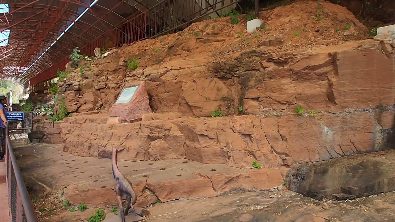
 Click to Access the Navigation Map GPS
Ban Phanom Dinosaur Footprints Map
Recommend
 Historical Sites and Monuments(3)
 Landmarks and Memorials(2)
 Art, Craft Centres, Tradition(3)
 Museums(3)
 Educational Places
 Library(1)
 Places of Worship
 Temple(23)
 Church(1)
 Other Sacred Sites(11)
 Suburban Living
 Village, Community(5)
 Nature and Wildlife
 National Parks and Marine Reserves(1)
 Dam, Reservoir, Lake(5)
 Waterfalls(2)
 River, Canal(3)
 Bays and Beaches(3)
 Other natural attractions(2)
 Entertainment and Agricultural
 Zoos and Aquariums(1)
 Farms, Parks and Ecotourism(2)
 Shopping
 Shopping and Night Market(1)


