
lovethailand home >Northeastern Travel Attractions >Chaiyaphum Travel Attractions >Phakdi Chum Phon >Chao Thong > Sai Rung Waterfall
TL;DR: Sai Rung Waterfall is located at Ban Sap Prasit, Village No. 7, Chao Thong Subdistrict, Phakdi Chumphon District, Chaiyaphum Province, open Daily, hours 08.00 – 17.00.

Sai Rung Waterfall
Open Days: Daily
Opening Hours: 08.00 – 17.00
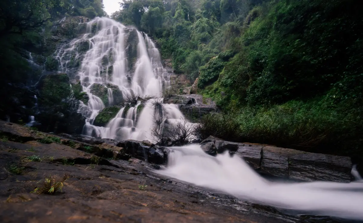
Sai Rung Waterfall in Chaiyaphum Province is a natural waterfall in the Ban Sap Prasit area of Chao Thong Subdistrict, Phakdi Chumphon District. The waterfall is about 30 meters high and is located approximately 2,500 meters from Ban Sap Prasit village. It is a quiet local nature attraction connected with rural communities, forest routes, and the landscape of Phakdi Chumphon. The waterfall can be reached by two main routes: from Ban Huai Hin Fon to Ban Sap Prasit for about 6 km, then continuing another 2,500 meters to the waterfall, or from Ban Lat Sai Ngam to Sai Rung Waterfall for about 8 km.
Sai Rung Waterfall is best suited for travelers who appreciate local natural places rather than heavily developed tourist facilities. The experience begins before reaching the waterfall itself, as visitors travel through village roads, rural scenery, and community routes before entering the natural area. This makes the journey part of the attraction. The site is not located directly on a major highway, so visitors should plan carefully, check the route conditions, and prepare for a more local-style nature trip.
The name “Sai Rung” means rainbow, giving the waterfall a poetic identity. When the water volume is good and sunlight touches the mist or spray at the right angle, the waterfall may create a fresh and luminous atmosphere that matches its name. This visual effect depends on water volume, sunlight, season, and viewing angle, but the name itself reflects the natural beauty that visitors hope to find at this 30-meter waterfall.
The waterfall is closely linked with Ban Sap Prasit because the village is only about 2,500 meters from the waterfall. For this reason, visitors should treat the local community with respect. They should drive slowly through village areas, avoid blocking access roads, avoid entering private farmland without permission, and keep noise to a minimum. Small natural attractions like this remain welcoming only when visitors behave responsibly and reduce their impact on local residents.
The best season to visit Sai Rung Waterfall is generally the rainy season to early cool season, when the waterfall has a higher chance of visible water flow. In the dry season, the amount of water may be much lower, and the landscape may look different. Travelers who want to see the waterfall at its most impressive should check recent rainfall and route conditions before traveling. This is especially important because the final section to the waterfall is a local nature route.
Getting There can be done by two main routes. The first route runs from Ban Huai Hin Fon to Ban Sap Prasit for about 6 km, then continues another 2,500 meters to the waterfall. The second route runs from Ban Lat Sai Ngam to Sai Rung Waterfall for about 8 km. A private car, motorcycle, or pickup truck is the most practical option. During the rainy season or after heavy rain, road conditions may change, so visitors should ask Chao Thong Municipality or local residents about the current route before entering the waterfall area.
Because the waterfall is in a natural setting, visitors should prepare properly. Non-slip shoes, drinking water, suitable outdoor clothing, mosquito repellent, a waterproof pouch for phones, and a rubbish bag are recommended. Carrying heavy bags into the waterfall area is not ideal because local paths can become slippery or uneven, especially when wet. A lighter and more careful visit is safer and more comfortable.
Safety is important at Sai Rung Waterfall. The waterfall is about 30 meters high, and natural waterfall areas often include slippery rocks, steep edges, wet ground, and uneven surfaces. Visitors should not climb rocks for photographs, stand near cliff edges, enter fast-moving water, or walk into areas where the ground cannot be clearly seen. Children should always stay close to adults, and elderly visitors should choose stable viewing areas.
If traveling during the rainy season, visitors may find greener forest scenery and a stronger waterfall flow. However, the rainy season also brings slippery paths, sudden changes in water level, and possible runoff from upper areas. If there has been heavy rain, it is better to view the waterfall from a safe distance rather than walking close to the water. The goal of a nature trip should be to enjoy the place safely and leave without damaging the area.
The best time of day to visit is morning to early afternoon. Visitors should avoid entering the waterfall area too late in the day because the return route may have limited light. Natural routes near villages and forests can become more difficult after sunset, especially if the weather changes or the road becomes muddy. Planning to return before dark is strongly recommended.
For photography, Sai Rung Waterfall offers several interesting subjects: the 30-meter waterfall face, water spray, forest scenery, natural rocks, the route through Ban Sap Prasit, and the rural setting of Chao Thong Subdistrict. Photographers should choose safe viewpoints and avoid climbing wet rocks for risky angles. The best photographs often come from patient observation rather than getting dangerously close to the waterfall.
Sai Rung Waterfall can be combined with other attractions in Phakdi Chumphon District and nearby areas. Visitors may include Khao Phang Hoei Viewpoint, Pha Thong Waterfall, Phu Pha Thong Cave, Sai Thong National Park, Sai Thong Waterfall, or the Bua Sawan flower fields in a wider Chaiyaphum nature itinerary. A careful route plan allows travelers to experience waterfalls, viewpoints, forests, rural villages, and national park landscapes in one trip.
Food services are more reliable in Chao Thong, Wang Thong, and Phakdi Chumphon town than near the waterfall itself. Travelers should eat before entering the waterfall route or plan a meal after returning from the site. Drinking water and light snacks should be prepared, but all rubbish must be carried back out. Leaving waste in a local waterfall area damages both the natural landscape and the relationship with the surrounding community.
Accommodation is available in Phakdi Chumphon District and nearby areas such as Wang Thong. Staying near Phakdi Chumphon is useful for travelers who want to start early and visit Sai Rung Waterfall before continuing to viewpoints or national park attractions. Visitors should contact accommodation providers in advance, especially on weekends, public holidays, or during the flower season around Sai Thong National Park.
Sai Rung Waterfall is also valuable because it reflects the identity of local nature tourism in Chao Thong Subdistrict. The attraction connects Ban Huai Hin Fon, Ban Sap Prasit, and Ban Lat Sai Ngam through local routes. Its tourism value does not come only from the waterfall itself, but also from the surrounding communities, road access, rural scenery, and the cooperation needed to keep the route usable and the natural area clean.
Responsible travel is essential. Visitors should not leave rubbish, use loud music, damage plants, enter private land, or drive carelessly on community roads. They should not use soap or chemicals in natural water and should avoid disturbing wildlife. A small waterfall in a local community can remain beautiful only when visitors help protect it.
Families can visit Sai Rung Waterfall if they prepare carefully, but the route and natural terrain may not be suitable for every group. Children should wear secure footwear and stay close to adults. If the ground is wet, if water is strong, or if the final route is difficult, it is better to stop at a safer viewpoint or postpone the visit. Safety should always come before reaching the waterfall at any cost.
In summary, Sai Rung Waterfall is a natural waterfall in Chao Thong Subdistrict, Phakdi Chumphon District, Chaiyaphum Province. It is about 30 meters high and located around 2,500 meters from Ban Sap Prasit. Visitors can access it from Ban Huai Hin Fon through Ban Sap Prasit, or from Ban Lat Sai Ngam. The waterfall is best for travelers who enjoy local nature, rural routes, forest scenery, and quiet waterfall landscapes. With proper preparation, route checking, and respect for the community, Sai Rung Waterfall can be a memorable nature stop in Chaiyaphum.
| Name | Sai Rung Waterfall |
| Location | Ban Sap Prasit, Village No. 7, Chao Thong Subdistrict, Phakdi Chumphon District, Chaiyaphum Province |
| Address | Ban Sap Prasit / Ban Lat Sai Ngam Route, Chao Thong Subdistrict, Phakdi Chumphon District, Chaiyaphum 36260, Thailand |
| Highlights | A natural waterfall about 30 meters high, located about 2,500 meters from Ban Sap Prasit, with two local access routes through Chao Thong Subdistrict |
| Distinctive Features | A quiet local waterfall in a forest and village landscape, suitable for nature viewing, photography, and conservation-minded travel |
| Name Origin | “Sai Rung” means rainbow, referring to the beauty of water and spray that may appear luminous when sunlight and water conditions are suitable |
| Travel Information | Route 1: Ban Huai Hin Fon to Ban Sap Prasit, about 6 km, then another 2,500 meters to the waterfall Route 2: Ban Lat Sai Ngam to Sai Rung Waterfall, about 8 km |
| Current Status | A local natural attraction in Chao Thong Subdistrict, Phakdi Chumphon District, Chaiyaphum Province, with community routes leading to the waterfall |
| Open Days | Daily |
| Opening Hours | 08.00 – 17.00 |
| Facilities | Community access routes, nature-viewing areas, photo spots, natural resting areas, and food/accommodation services in Chao Thong, Wang Thong, and Phakdi Chumphon town |
| Main Areas / Zones | 1. Ban Huai Hin Fon – Ban Sap Prasit Route 2. Ban Lat Sai Ngam – Sai Rung Waterfall Route 3. Access section from Ban Sap Prasit to the waterfall 4. Forest and natural trail area before the waterfall 5. Waterfall face, about 30 meters high 6. Water spray and viewing area 7. Nature photo and resting area |
| Caretaker | Chao Thong Municipality, Phakdi Chumphon District, Chaiyaphum Province, together with the local communities of Ban Sap Prasit and Ban Lat Sai Ngam |
| Main Contact Number | Chao Thong Municipality Tel. 0-4410-9663 / Fax 0-4482-8232 |
| Official Website / Official Page | Chao Thong Municipality, Phakdi Chumphon District, Chaiyaphum / Local Tourism Information: Sai Rung Waterfall |
| Nearby Tourist Attractions | 1. Ban Sap Prasit, about 2.5 km 2. Ban Lat Sai Ngam, about 8 km 3. Ban Sap Prasit Sweet Tamarind Orchard Area, about 3 km 4. Khao Phang Hoei Viewpoint, about 25 km 5. Pha Thong Waterfall / Phu Pha Thong Cave, about 30 km 6. Sai Thong National Park, about 35 km 7. Sai Thong Waterfall, about 40 km 8. Bua Sawan Flower Field, Sai Thong National Park, about 45 km |
| Nearby Restaurants | 1. Pordeekum Cafe & Bistro, Chao Thong Subdistrict, about 18 km, Tel. 099-342-4941 2. Le Khuat Chaiyaphum, Phakdi Chumphon District, about 20 km, Tel. 092-603-3883 3. Khrua Naphat Restaurant, Chao Thong Subdistrict, about 20 km, Tel. 083-375-7941 4. Pla Thu Mae Kham Bu, Chao Thong Subdistrict, about 20 km, Tel. 083-079-8823 5. U Cafe, Wang Thong Subdistrict, about 25 km, Tel. 083-038-5678 6. Ban Chef Damri Restaurant, Wang Thong Subdistrict, about 25 km, Tel. 081-869-7091 |
| Nearby Accommodations | 1. Baan Rai Thaiyabhume, Wang Thong Subdistrict, about 25 km, Tel. 063-848-8558 2. Jarunee Resort, Wang Thong Subdistrict, about 25 km, Tel. 088-374-1485 3. Baan Ton Tan Resort And Hong Nang, Wang Thong Subdistrict, about 25 km, Tel. 098-245-9394 4. Baan Phu Tawan Resort, Phakdi Chumphon District, about 25 km, Tel. 084-246-9555 5. Baan Phak Heng Somjaiwang, Wang Thong Subdistrict, about 25 km 6. Sai Thong National Park Accommodation / Service Area, about 35 km, Tel. 089-282-3437 |
Frequently Asked Questions (FAQ)
Q: Where is Sai Rung Waterfall located?
A: Sai Rung Waterfall is located near Ban Sap Prasit, Chao Thong Subdistrict, Phakdi Chumphon District, Chaiyaphum Province. It is about 2,500 meters from Ban Sap Prasit village.
Q: What makes Sai Rung Waterfall special?
A: It is a natural waterfall about 30 meters high, located in a quiet forest and village landscape with two local access routes through Chao Thong Subdistrict.
Q: How many routes lead to Sai Rung Waterfall?
A: There are two main routes. One route runs from Ban Huai Hin Fon to Ban Sap Prasit for about 6 km and continues another 2,500 meters to the waterfall. The other route runs from Ban Lat Sai Ngam to the waterfall for about 8 km.
Q: What are the opening hours of Sai Rung Waterfall?
A: Sai Rung Waterfall is open daily from 08.00 to 17.00.
Q: When is the best time to visit Sai Rung Waterfall?
A: The rainy season to early cool season is usually the best time because the waterfall is more likely to have visible water flow. Visitors should check weather and route conditions before traveling.
Q: Can visitors swim at Sai Rung Waterfall?
A: Visitors should focus on nature viewing and photography. If going near the water, they should choose only safe areas and avoid strong current, slippery rocks, and steep sections near the waterfall.
Q: What should visitors bring?
A: Visitors should bring non-slip shoes, drinking water, suitable outdoor clothing, a waterproof phone pouch, mosquito repellent, and a rubbish bag.
Q: Who can visitors contact for local route information?
A: Visitors can contact Chao Thong Municipality, Phakdi Chumphon District, Chaiyaphum Province, at 0-4410-9663 for local area and route information.
 Category: ●Nature and Wildlife
 Group: ●Waterfalls
Last Update : 3 MonthAgo
 Last Update : 3 MonthAgo
 Click to Access the Navigation Map GPS
 Art, Culture and Heritage
 Historical Sites and Monuments(1)
 Landmarks and Memorials(3)
 Royal Palace(1)
 Art, Craft Centres, Tradition(3)
 Educational Places
 Educational Gardens, Farm(1)
 Places of Worship
 Temple(141)
 Other Sacred Sites(7)
 Suburban Living
 Village, Community(4)
 National Parks and Marine Reserves(7)
 Mountain (Doi)(5)
 Dam, Reservoir, Lake(10)
Waterfalls(15)
Dam, Reservoir, Lake(10)
Waterfalls(15)
 Caves(5)
 River, Canal(4)
 Other natural attractions(1)
 Entertainment and Agricultural
 Farms, Parks and Ecotourism(2)


