lovethailand home >Northeastern Travel Attractions >Chaiyaphum Travel Attractions >Nong Bua Raheo >Wang Takhe > Sai Thong National Park
TL;DR: Sai Thong National Park is located at Wang Takhe Subdistrict, Nong Bua Rawe District, Chaiyaphum Province, Thailand, open Daily During The Official Travel And Camping Season, hours 08.00 – 16.30.

Sai Thong National Park

Open Days: Daily During The Official Travel And Camping Season
Opening Hours: 08.00 – 16.30
Sai Thong National Park in Chaiyaphum Province is one of northeastern Thailand’s most rewarding nature destinations, especially for travelers who want to experience waterfalls, mountain cliffs, forest trails, seasonal Siam tulip fields, dramatic viewpoints, and camping areas within a single protected landscape. The park is best known for Thung Bua Sawan, the wild Siam tulip fields that bloom beautifully during the rainy season, together with Pha Ham Hod, Pha Pho Mueang, Pha Phloen Chai, Pha Athit Atsadong, Sai Thong Waterfall, Wang Ngueak, Chuan Chom Waterfall, Hin Thoen, and Khao Phang Hoei Viewpoint. For foreign travelers, this park offers an authentic introduction to the mountain forests of Isan, far from the more crowded tourist routes of Thailand.
Sai Thong National Park covers forested areas on the Phang Hoei mountain range across Nong Bua Rawe, Thep Sathit, Phakdi Chumphon, and Nong Bua Daeng districts of Chaiyaphum Province. The park covers about 319 square kilometers, or approximately 199,375 rai. It is an important watershed forest where several streams originate before flowing into tributaries of the Chi River. This gives Sai Thong importance not only as a tourist destination, but also as a protected natural area that helps maintain water resources, forest ecosystems, and biodiversity in western Chaiyaphum.
The landscape of Sai Thong National Park is shaped by the rugged Phang Hoei mountain range. Some areas are high ridges, some are cliffs, and others are rock terraces, streams, and forest valleys. The park contains dry dipterocarp forest, dry evergreen forest, and mixed deciduous forest, with large numbers of ruak bamboo growing in many places. These forest types create a varied environment that supports streams, waterfalls, seasonal flowers, wildlife, and scenic viewpoints. The result is a park that feels diverse rather than repetitive, with each area offering a different natural character.
The best season to visit Sai Thong National Park is from the rainy season into the early cool season. During the rainy season, the forest becomes fresh and green, the waterfalls carry more water, and the Siam tulips begin to bloom across Thung Bua Sawan. The most popular flower-viewing period is from late June to mid-August, when pink and white Siam tulips appear naturally across the highland fields. From November to January, the area also supports small seasonal wildflowers such as Dusita, Soi Suwanna, Kradum Ngoen, and Kradum Thong, giving the park continued botanical interest after the main Siam tulip season.
Sai Thong Waterfall is one of the easiest attractions to reach from the park headquarters. It is located about 1 kilometer by vehicle from the office, followed by a walk of about 400 meters. Although the waterfall is only about 5 meters high, it is approximately 80 meters wide, creating an impressive sheet of water flowing across a broad natural rock face. In front of the waterfall is a large pool where visitors can swim in safe areas. The waterfall is especially suitable for families and travelers who want a relaxing nature stop without a long hike.
Above Sai Thong Waterfall is a large natural pool known as Wang Ngueak. Here, water flows gently along low rock rapids for more than 100 meters, creating a soft and scenic stream landscape. Nearby stands a giant old krabak tree often referred to as the thousand-year krabak tree. Its enormous size reflects the richness and age of the forest ecosystem around the waterfall. This area is ideal for slow walking, photography, and observing how streams, rock surfaces, and old forest trees connect within the park’s watershed environment.
Chuan Chom Waterfall is located upstream from Sai Thong Waterfall along a nature trail of about 2 kilometers. The waterfall is about 20 meters high and is surrounded by shaded forest. It offers a quieter atmosphere than the main waterfall and is suitable for visitors who enjoy walking through forest trails. Along the route, travelers can experience the dry evergreen and mixed deciduous forest environment, bamboo stands, and small streams that form part of Sai Thong’s watershed system. Good walking shoes and drinking water are useful, especially during the rainy season when the trail can become damp and slippery.
Pha Pho Mueang is a cliff line along the western ridge of the Phang Hoei mountain range, on the route toward Thung Bua Sawan. The area sits roughly 700–900 meters above sea level. From the cliff, visitors can look down toward Phakdi Chumphon District and see the Phaya Fo mountain range, which separates parts of Chaiyaphum from Phetchabun Province. This viewpoint helps travelers understand the geography of the region, where high forested ridges, valleys, lowlands, and communities are connected within one broad landscape.
Pha Ham Hod is one of the most famous and dramatic viewpoints in Sai Thong National Park. It is located about 10 kilometers from the park headquarters on the highest ridge of the Phang Hoei mountain range, about 864 meters above sea level. The viewpoint is known for a projecting rock ledge extending from the cliff. It offers wide views and creates a thrilling photo opportunity. Visitors must be very careful near the cliff edge, stay only in safe areas permitted by park officers, and avoid risky poses, especially when the rock surface is wet after rain.
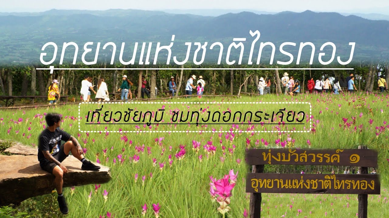
Thung Bua Sawan, the Siam tulip field of Sai Thong National Park, is located about 12 kilometers from the park headquarters. The flowers grow naturally across highland fields and forest edges, with both pink and white blooms. The beauty of Thung Bua Sawan comes from more than the flowers themselves. Visitors reach the fields by moving through a sequence of natural landscapes, including parking areas, camping zones, cliffs, rock terraces, and forest paths. The journey feels like a mountain nature walk rather than a simple flower-garden visit.
The walking route to the Siam tulip fields begins after visitors travel from the park headquarters to the upper parking and camping area, a distance of about 9 kilometers. Travelers can drive or hire a local pickup service from the park headquarters. From there, the walking route passes Pha Pho Mueang, Pha Ham Hod, Pha Phloen Chai, Thung Bua Sawan 2 with pink Siam tulips, the white Siam tulip field, and Pha Athit Atsadong. The walk from the parking area to Pha Ham Hod is about 300 meters. From Pha Ham Hod, it is about 1,300 meters to the pink flower field and another 700 meters to the white flower field.
Because the Siam tulip season coincides with the rainy season, visitors should prepare carefully. A raincoat, umbrella, non-slip shoes, waterproof phone bag, drinking water, and light walking clothes are highly recommended. Some sections of the route may be muddy or slippery after rainfall. Visitors should start early in the day, walk at a comfortable pace, and stay on marked paths. Remaining on the designated trail protects the flowers and prevents damage to fragile plants growing naturally in the field.
Pha Phloen Chai and Pha Athit Atsadong add more scenic value to the flower-viewing route. Pha Phloen Chai offers an open cliff atmosphere with cool wind and broad landscape views. Pha Athit Atsadong, whose name refers to sunset, is suitable for evening light when the sun lowers over the forested mountain horizon. Visitors who plan to stay for sunset should carry a flashlight and plan the walk back carefully, as natural trails become darker quickly after evening.
Hin Thoen is another unusual natural feature within Sai Thong National Park. It consists of a large rock about 10 meters wide and 5 meters high balanced on a much smaller rock beneath it. The formation appears surprisingly stable and has become a point of interest for travelers who enjoy geological features and unusual landscapes. Hin Thoen demonstrates how weathering, erosion, and long-term natural processes can create forms that look almost impossible at first glance.
Khao Phang Hoei Viewpoint is located beside Highway 225 on the Chaiyaphum–Nakhon Sawan route, around kilometer marker 70. It is a convenient roadside stop for resting and enjoying views of the forest and overlapping ridges of the Phang Hoei mountain range. Looking down from this point, visitors can see broad lowland areas toward Phetchabun Province. The viewpoint is especially attractive in the late afternoon, when the setting sun creates warm light and shadow across the mountains and plains below.
In addition to its main attractions, Sai Thong National Park offers a strong camping atmosphere. The Pha Pho Mueang camping zone and areas near the upper route to Thung Bua Sawan are especially popular during the Siam tulip season because they allow visitors to start their flower-field walk early in the morning. Staying overnight gives travelers a chance to experience cool mountain air, quiet forest surroundings, misty morning views, and a night sky far from city lights.
The park provides accommodation, camping areas, and food services during the travel season. Travelers planning to stay overnight should contact the park before visiting, particularly during the Siam tulip festival period when visitor numbers increase. Useful personal items include a raincoat, light jacket, flashlight, mosquito repellent, personal rubbish bag, medicine, and suitable shoes for wet or rocky ground. Good preparation makes the experience safer and more comfortable.
Traveling to Sai Thong National Park from Chaiyaphum city is straightforward by private car. Take Highway 225 on the Chaiyaphum–Nakhon Sawan route for about 65 kilometers, then turn right at the signposted junction and continue for about 7 kilometers to the park headquarters. Travelers heading to Thung Bua Sawan should allow extra time for the upper route and walking trail. The route to the flower fields involves either driving or hiring a pickup service from the park headquarters to the upper parking area before continuing on foot to the cliffs and flower fields.
Getting There from Bangkok can be planned through Saraburi, Lop Buri, or Phetchabun, depending on the preferred route, before continuing toward Chaiyaphum and Highway 225. Many travelers combine Sai Thong National Park with Pa Hin Ngam National Park because both are famous for Siam tulip fields. However, the two parks have different atmospheres. Sai Thong is especially known for its cliff-walking route, mountain ridges, and more adventurous flower-field trail, while Pa Hin Ngam is famous for its broad flower fields and distinctive rock garden.
A one-day trip to Sai Thong National Park is possible if visitors focus on key sites such as Sai Thong Waterfall, Wang Ngueak, the thousand-year krabak tree, and nearby viewpoints. Travelers who want to visit Thung Bua Sawan, Pha Ham Hod, and the cliff route should start early in the morning and allow enough time for walking. A two-day, one-night trip is the best option for those who want to enjoy the Siam tulip fields, camp near the ridge, see the morning atmosphere, and visit the waterfall without rushing.
The general entrance fee for Sai Thong National Park is 40 baht for Thai adults, 20 baht for Thai children, 200 baht for foreign adults, 100 baht for foreign children, and 30 baht for cars. The fee supports park management, waste control, trail maintenance, visitor services, safety work, and nature conservation. Visitors should carry some cash because phone signal and internet access may not be reliable in every area of the park.
Responsible travel is essential when visiting the Siam tulip fields. Visitors should not pick flowers, step outside designated paths, damage rock formations, write on stones, leave rubbish, feed wildlife, or remove plants from the park. Siam tulips are seasonal wild plants that depend on specific natural conditions. Staying on the trail helps protect the flower fields and ensures that Thung Bua Sawan remains beautiful for future visitors.
Overall, Sai Thong National Park offers a complete nature experience with waterfalls, forest, cliffs, seasonal flowers, viewpoints, camping areas, and walking trails. Its strongest appeal is the feeling of moving through real mountain nature: from waterfall and watershed forest to high ridges, cliff viewpoints, flower fields, and broad views over the Phang Hoei range. For travelers who want to explore Chaiyaphum beyond the usual routes, Sai Thong is one of the province’s most memorable rainy-season destinations.
| Name | Sai Thong National Park |
| Location | Wang Takhe Subdistrict, Nong Bua Rawe District, Chaiyaphum Province, Thailand |
| Address | 81 Moo 10, Wang Takhe Subdistrict, Nong Bua Rawe District, Chaiyaphum 36250, Thailand |
| Covered Area | Nong Bua Rawe, Thep Sathit, Phakdi Chumphon, And Nong Bua Daeng Districts In Chaiyaphum Province |
| Area | About 319 Sq Km, Or Approximately 199,375 Rai |
| Coordinates | 15.7890, 101.4410 |
| Highlights | Thung Bua Sawan, Sai Thong Waterfall, Wang Ngueak, Thousand-Year Krabak Tree, Chuan Chom Waterfall, Pha Pho Mueang, Pha Ham Hod, Pha Phloen Chai, Pha Athit Atsadong, Hin Thoen, And Khao Phang Hoei Viewpoint |
| Distinctive Features | Mountain forest on the Phang Hoei range with dry dipterocarp forest, dry evergreen forest, mixed deciduous forest, waterfalls, rock terraces, cliffs, Siam tulip fields, and nature trails |
| Best Time To Visit | Rainy Season To Early Cool Season. Siam Tulips Are Best Seen From Late June To Mid-August, While Small Seasonal Wildflowers Appear From November To January |
| Travel Information | From Chaiyaphum city, take Highway 225 toward Nakhon Sawan for about 65 km, then turn right and continue about 7 km to the park headquarters. To reach Thung Bua Sawan, continue by car or hired pickup to the upper parking area and walk to the cliffs and flower fields |
| Current Status | Officially open for tourism and overnight stays from 16 May 2026 during the travel season |
| Open Days | Daily During The Official Travel And Camping Season |
| Opening Hours | 08.00 – 16.30 |
| Fees | Thai Adults: 40 Baht, Thai Children: 20 Baht Foreign Adults: 200 Baht, Foreign Children: 100 Baht Car Fee: 30 Baht |
| Facilities | Visitor service center, park accommodation, camping areas, welfare restaurant, restrooms, parking areas, and seasonal visitor service points |
| Main Areas / Zones | Sai Thong Waterfall Wang Ngueak Thousand-Year Krabak Tree Chuan Chom Waterfall Pha Pho Mueang Pha Ham Hod Pha Phloen Chai Thung Bua Sawan 1 Thung Bua Sawan 2 White Siam Tulip Field Pha Athit Atsadong Hin Thoen Khao Phang Hoei Viewpoint Pha Pho Mueang Camping Area |
| Caretaker | Mr. Kannaphat Duangklang, Chief Of Sai Thong National Park |
| Main Contact Number | 089-282-3437 |
| Official Website / Official Page | Sai Thong National Park Official Page |
| Nearby Tourist Attractions | 1. Khao Phang Hoei Viewpoint, about 8 km 2. Pha Ham Hod, about 10 km 3. Thung Bua Sawan, about 12 km 4. Pa Hin Ngam National Park, about 38 km 5. Thep Sathit Wind Farm, about 45 km |
| Nearby Restaurants | 1. Sai Thong National Park Food And Drink Center, about 1 km 2. Wela Coffee, about 3 km 3. Tong Ya, about 10 km, Tel. 081-910-1245 4. Lekuat Steak & Coffee Phakdi Chumphon, about 11 km, Tel. 080-485-6888 5. U-Cafe, about 13 km |
| Nearby Accommodations | 1. Sai Thong National Park Accommodation, about 1 km, Tel. 089-282-3437 2. Pha Pho Mueang Camping Area, about 9 km, Tel. 089-282-3437 3. Manjai Resort, about 27 km 4. Baan Tung Dok Krajeaw Highland Resort, about 30 km, Tel. 081-900-5332 5. Touch The Wind Restaurant & Resort, about 36 km |
Frequently Asked Questions (FAQ)
Q: Where is Sai Thong National Park located?
A: Sai Thong National Park is located in Wang Takhe Subdistrict, Nong Bua Rawe District, Chaiyaphum Province, and covers parts of Nong Bua Rawe, Thep Sathit, Phakdi Chumphon, and Nong Bua Daeng districts.
Q: When is the best time to see Siam tulips at Sai Thong National Park?
A: The best period is from late June to mid-August, when pink and white Siam tulips bloom naturally in the Thung Bua Sawan area.
Q: What are the main highlights of Sai Thong National Park?
A: Main highlights include Thung Bua Sawan, Sai Thong Waterfall, Wang Ngueak, the thousand-year krabak tree, Chuan Chom Waterfall, Pha Pho Mueang, Pha Ham Hod, Pha Phloen Chai, Pha Athit Atsadong, Hin Thoen, and Khao Phang Hoei Viewpoint.
Q: How far is the walk to Pha Ham Hod and Thung Bua Sawan?
A: From the upper parking area, it is about 300 meters to Pha Ham Hod, about 1,300 meters farther to the pink Siam tulip field, and another 700 meters to the white Siam tulip field.
Q: How much is the entrance fee?
A: Thai adults pay 40 baht and Thai children pay 20 baht. Foreign adults pay 200 baht and foreign children pay 100 baht. The car fee is 30 baht.
Q: Is accommodation or camping available in Sai Thong National Park?
A: Yes. Park accommodation and camping areas are available during the travel season. Visitors should contact the park before traveling to check service areas and availability.
Q: How do visitors get to Sai Thong National Park?
A: From Chaiyaphum city, take Highway 225 toward Nakhon Sawan for about 65 km, then turn right and continue about 7 km to the park headquarters.
Q: What should travelers bring when visiting Sai Thong National Park?
A: Non-slip shoes, a raincoat, umbrella, drinking water, waterproof phone bag, flashlight, mosquito repellent, and cash are recommended, especially during the rainy season.
Mobile : 0892823437
![]() Category: ●Nature and Wildlife
Category: ●Nature and Wildlife
![]() Group: ●National Parks and Marine Reserves
Group: ●National Parks and Marine Reserves
Last Update : 1 WeekAgo
Sai Thong National Park Map
Gellery
Recommend


