
lovethailand home >North Travel Attractions >Uthai Thani Travel Attractions >Muang Uthai Thani >Koh The Pho > Ko Thepho
TL;DR: Ko Thepho is located at Ko Thepho Subdistrict / Area Near Hat Thanong Subdistrict, Mueang Uthai Thani District, Uthai Thani Province, open Daily, hours Morning To Late Afternoon During Daylight Hours Is Recommended.
Ko Thepho
Open Days: Daily
Opening Hours: Morning To Late Afternoon During Daylight Hours Is Recommended
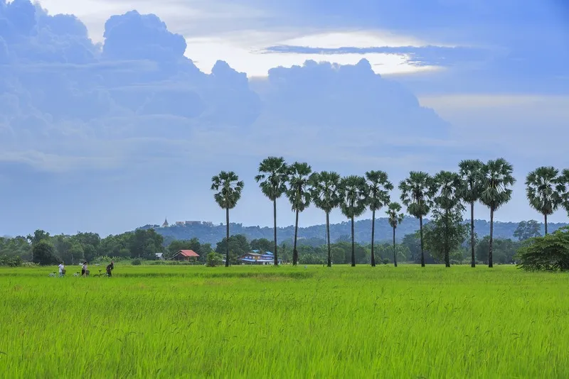
Ko Thepho in Uthai Thani Province is a distinctive freshwater island and community-based travel area in Mueang Uthai Thani District. It is known for its connection to the Chao Phraya River and the Sakae Krang River, quiet agricultural landscapes, pomelo orchards, bamboo groves, rice fields, local temples, cycling routes, and handmade community products. More than a green area near town, Ko Thepho reflects the relationship between rivers, farming, local craftsmanship, and the slow rural way of life that gives Uthai Thani its unique charm.
Historically, the area was originally a peninsula between the Chao Phraya River and the Sakae Krang River, where the two waterways met toward the southern side. Later, a canal was dug in the northern section to allow water from the Chao Phraya River to support the Sakae Krang River during the dry season. This changed the peninsula into a complete island surrounded by water. The story of Ko Thepho therefore combines natural river geography with local water management and settlement history.
Ko Thepho is located very close to Uthai Thani town. Visitors can begin from the municipal market area, Wat Uposatharam, or the Sakae Krang riverside, then cross a small bridge into the island area. The moment travelers cross from the town side into Ko Thepho, the atmosphere changes noticeably. The town scene gives way to orchards, bamboo groves, fields, village roads, and quiet rural surroundings, making the island suitable for slow travel and bicycle touring.
Cycling around Ko Thepho is one of the most popular ways to experience the island. The full cycling route is approximately 33 km and passes through agricultural areas, villages, temples, and shaded rural roads. Along the way, visitors can see bamboo groves, corn fields, rice fields, pomelo orchards, and local homes. This makes cycling here more than a recreational activity; it is a way to move through real community landscapes and experience Uthai Thani at a slower pace.
The scenery along Ko Thepho’s cycling route is peaceful and refreshing. Some parts of the road are shaded by trees and bamboo, while other sections open onto fields and orchards. The route allows travelers to stop for photos, observe local life, and enjoy the calm rhythm of rural Uthai Thani without traveling far from the provincial town. It is especially suitable for visitors who prefer quiet, open-air travel rather than crowded attractions.
Pomelo is one of the island’s well-known agricultural products. Local farmers grow varieties such as Manorom and Khao Taengkwa, and some areas also grow mafai and seasonal crops. These orchards give Ko Thepho a green agricultural identity and help support local livelihoods. Visitors who come during the fruit season can see how orchards, village roads, and riverside landscapes form part of the island’s everyday life.
Ban Tha Din Daeng is one of the community areas that reflects Ko Thepho’s local craftsmanship. Along the route, visitors may find lamphaen mats made from bamboo. These mats are crafted using local knowledge and materials found in the area. They are simple but meaningful products because they show how villagers transform local resources into useful household items. Buying directly from local households is also a way to support the community economy.
Wat Phumtham is another worthwhile stop on the island route. The temple offers a quiet place to rest during a cycling trip and gives visitors a chance to experience a small local Buddhist site within the rural landscape. Temples on Ko Thepho are not only religious places but also community spaces where local life, faith, and travel meet naturally.
Ko Thepho is also known for local OTOP products. These include processed fish products, community food products, steel knives, bamboo basketry, and scented incense. Processed fish products connect with the river and fishing way of life, while knives and bamboo crafts reflect skilled local workmanship. These community products add cultural value to a visit and make the island more than just a cycling destination.
The island is closely connected to the Sakae Krang River experience. From Uthai Thani town, Ko Thepho appears as a green landscape opposite the floating raft-house communities, riverside markets, fish cages, and Wat Uposatharam. A trip to Ko Thepho can easily be combined with a boat ride on the Sakae Krang River, a visit to local markets, and a meal featuring freshwater fish from the area.
The best time to visit Ko Thepho is in the morning or late afternoon. Morning is ideal for cycling because the weather is cooler, the light is soft, and the village roads are calmer. Late afternoon is good for photography and enjoying the warm light over fields, orchards, and the river. Visitors planning to cycle the full 33 km route should start early enough to finish before dark.
Getting There is easy from Uthai Thani town. Visitors can use the municipal market or Wat Uposatharam as a reference point, then cross the bridge into Ko Thepho. A private car, motorcycle, or bicycle can be used depending on the intended route. Travelers who plan to cycle a long distance should bring drinking water, a helmet, basic repair tools, and a route map.
Safety is important when cycling on Ko Thepho. Cyclists should keep left, ride at a moderate speed, and watch for motorcycles, local vehicles, dogs, and farm access points. Visitors should avoid blocking house entrances, garden entrances, and village roads. The best cycling experience here comes from respecting the pace of the community while enjoying the landscape.
Visitors who do not want to complete the full cycling route can choose a shorter visit. They can cross from Wat Uposatharam, ride or walk through nearby orchards and village roads, stop for community products, take photos, and return to town. This shorter version is suitable for families, elderly visitors, or travelers with limited time.
Ko Thepho is suitable for cyclists, families, photographers, nature lovers, cultural travelers, and visitors who want to experience Uthai Thani slowly. Photographers will find bridges, rural roads, bamboo groves, orchards, fields, and community life useful for storytelling images. Cultural travelers will appreciate the local products, temples, farming way of life, and the island’s connection with the river.
Good travel etiquette is important. Visitors should not pick fruit without permission, should not enter private farmland, should not leave trash behind, and should ask before taking close-up photos of local people. Supporting local shops, fruit sellers, or community products helps distribute tourism income directly to the island community.
A well-planned Ko Thepho route can begin at Uthai Thani municipal market, continue to Wat Uposatharam, cross into the island, cycle through orchards and villages, pass Ban Tha Din Daeng and Wat Phumtham, then continue toward the ferry area near Wat Tha Sung or return to Uthai Thani town according to time and fitness level. This route combines old-town atmosphere, riverside temples, orchards, local crafts, and rural scenery in one trip.
Overall, Ko Thepho brings together several layers of value: freshwater island geography, a history of river and canal change, cycling routes, agriculture, community products, local temples, and quiet green landscapes near Uthai Thani town. A visit here helps travelers understand Uthai Thani beyond its city center, showing how rivers, land, and local life remain closely connected.
Ko Thepho is therefore one of the most rewarding destinations in Uthai Thani for slow travel. Whether visitors cycle the full route, explore only a short section, buy community products, enjoy orchards, or simply cross the bridge to experience the rural atmosphere, the island offers a calm, authentic, and memorable side of Uthai Thani.
| Name | Ko Thepho |
| Location | Ko Thepho Subdistrict / Area Near Hat Thanong Subdistrict, Mueang Uthai Thani District, Uthai Thani Province |
| Address | Mueang Uthai Thani District, Uthai Thani 61000, Thailand |
| Highlights | Large freshwater island, 33 km cycling route, pomelo orchards, bamboo groves, rice fields, Ban Tha Din Daeng, lamphaen mats, Wat Phumtham, and local OTOP products |
| History / Importance | Originally a peninsula between the Chao Phraya River and the Sakae Krang River, later becoming a freshwater island after a northern canal was dug to connect the waterways |
| Name Origin | The name is associated with the freshwater island landscape between the Chao Phraya and Sakae Krang river systems and the agricultural-riverside community of Uthai Thani |
| Distinctive Features | Agricultural island with Manorom and Khao Taengkwa pomelo orchards, mafai, corn fields, rice fields, bamboo groves, lamphaen mat weaving, and a popular cycling route |
| Travel Information | Travel to Uthai Thani town, use the municipal market or Wat Uposatharam as a reference point, then cross the bridge into Ko Thepho. Private car, bicycle, or motorcycle is suitable |
| Current Status | A community, agricultural area, and cycling-based local tourism destination in Mueang Uthai Thani District |
| Open Days | Daily |
| Opening Hours | Morning to late afternoon during daylight hours is recommended |
| Facilities | Community roads, cycling route, bridge connection from town, temples for resting, local shops, and community products in some areas |
| Main Areas / Zones | Bridge from town, Wat Uposatharam, Ko Thepho cycling route, Ban Tha Din Daeng, Wat Phumtham, pomelo orchards, agricultural fields, rice fields, bamboo groves, and ferry route toward Wat Tha Sung |
| Caretaker / Local Authority | Ko Thepho Subdistrict Administrative Organization and Hat Thanong Municipality in related areas |
| Main Contact Number | Hat Thanong Municipality, Tel. 056-510-959 |
| Official Website / Official Page | www.kohthepo.go.th / www.hadthanong.go.th |
| Nearby Tourist Attractions | 1. Wat Uposatharam, about 1 km 2. Sakae Krang River, about 1 km 3. Uthai Thani Municipal Market, about 1 km 4. Trok Rong Ya, about 2 km 5. Wat Tha Sung, about 12 km |
| Nearby Restaurants | 1. Riverside Restaurants Along Sakae Krang River, about 1 km 2. Giant Gourami And Local Fish Restaurants Around Uthai Thani Market, about 1 km 3. Local Food Shops Around Trok Rong Ya, about 2 km 4. Local Restaurants On Ko Thepho, about 3 km 5. Cafes In Uthai Thani Old Town, about 2 km |
| Nearby Accommodations | 1. Uthai Heritage Hotel, about 2 km 2. Payamai Resort, about 3 km 3. River Marina Resort, about 5 km 4. Iyara Park Hotel & Resort, about 8 km 5. Local Guesthouses And Homestays In Uthai Thani Town, about 2 km |
Frequently Asked Questions (FAQ)
Q: Where is Ko Thepho located?
A: Ko Thepho is located in Mueang Uthai Thani District, Uthai Thani Province, near the Sakae Krang River, Wat Uposatharam, and Uthai Thani municipal market.
Q: What is special about Ko Thepho?
A: It is a large freshwater island known for cycling routes, pomelo orchards, rice fields, bamboo groves, Ban Tha Din Daeng, lamphaen mats, Wat Phumtham, and local OTOP products.
Q: How long is the Ko Thepho cycling route?
A: The full cycling route around Ko Thepho is approximately 33 km, making it suitable for travelers who enjoy slow cycling through nature and local communities.
Q: Where should visitors start a Ko Thepho trip?
A: A convenient starting point is Uthai Thani municipal market or Wat Uposatharam, then crossing the bridge into Ko Thepho.
Q: Who is Ko Thepho suitable for?
A: It is suitable for cyclists, families, photographers, nature lovers, cultural travelers, and visitors interested in orchards, village life, and slow travel near Uthai Thani town.
Q: What should visitors prepare?
A: Visitors should bring drinking water, sun protection, comfortable shoes, a camera, and, for longer cycling routes, a helmet and basic bicycle repair tools.
Q: What nearby places can be visited with Ko Thepho?
A: Nearby places include Wat Uposatharam, the Sakae Krang River, Uthai Thani municipal market, Trok Rong Ya, and Wat Tha Sung.
Mobile : 0862163510
 Mobile : 0862163510
 Category: ●Nature and Wildlife
 Group: ●Islands
Last Update : 4 MonthAgo
 Last Update : 4 MonthAgo
 Click to Access the Navigation Map GPS
 Art, Culture and Heritage
 Historical Sites and Monuments(3)
 Landmarks and Memorials(1)
 Art, Craft Centres, Tradition(5)
 Museums(1)
 Places of Worship
 Temple(31)
 Other Sacred Sites(3)
 Suburban Living
 Village, Community(4)
 Local Market(1)
 National Parks and Marine Reserves(2)
 Mountain (Doi)(7)
 Dam, Reservoir, Lake(5)
 Waterfalls(5)
 Hot Springs(1)
 Caves(9)
 Flower Field(2)
 River, Canal(2)
Islands(1)
River, Canal(2)
Islands(1)
 Other natural attractions(1)
 Entertainment and Agricultural
 Farms, Parks and Ecotourism(2)
 Shopping
 Shopping and Night Market(1)
 Travel Articles, Recipes
 Travel Review, Food Review(1)


