
lovethailand home >Central Travel Attractions >Suphan Buri Travel Attractions >Dan Chang >Ong Phra > Ban Khmer Rong
TL;DR: Ban Khmer Rong, Suphan Buri attractions : Suburban Living, Village, Community.
Ban Khmer Rong
Open Days: Contact the local community or Ong Phra Subdistrict Administrative Organization before visiting
Opening Hours: This is not a commercial tourist site with fixed daily opening hours
Ban Khmer Rong in Suphan Buri Province is one of the most distinctive mountain communities and nature routes in Dan Chang District. It is not a typical sightseeing spot with paved roads, ticket counters, or fixed visiting hours. Instead, it is a remote upland community connected with an old timber-hauling route, bamboo forest, steep dirt tracks, a local temple, and panoramic ridgelines that reveal another side of Suphan Buri beyond the province’s well-known markets, temples, and lowland attractions.
Ban Khmer Rong is located in Moo 1, Ong Phra Subdistrict, Dan Chang District, Suphan Buri Province. The area lies in a mountainous landscape where community life, forest paths, old logging history, and local faith are closely connected. The key landmark of the area is Wat Khmer Rong, a small local temple that serves as a spiritual center for villagers living on the mountain. The temple and the village are reached by a rugged route that is more suitable for four-wheel-drive vehicles than ordinary cars.
The name “Khmer Rong” is closely associated with an old timber-hauling route from the period when forests in this area were still under logging concessions. The concession was later closed in 1981, and the area became linked with community forest management around Ban Pa Khu Lang. This background gives Khmer Rong a deeper meaning than just a mountain road. It represents a transition from heavy forest exploitation to local forest care, from timber extraction to community-based conservation, and from a working forest route to a place that still carries traces of the past.
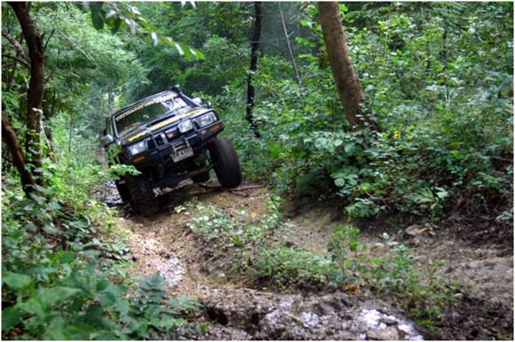
The Khmer Rong route can be understood in 2 main sections. The first section is about 3 kilometers long and leads toward Ban Khmer Rong and Wat Khmer Rong. This part of the route consists of dirt road, uneven rock surfaces, and rough uphill sections. Before reaching the village, travelers must pass 3 long steep slopes. During the dry season, the road is challenging but manageable for suitable vehicles and experienced drivers. During the rainy season, however, the surface becomes slippery, especially on steep slopes and rocky sections.
The second section continues beyond the village and cuts through bamboo forest, small shifting agricultural areas, and forest edges before climbing gradually toward higher ground. The trail twists between bamboo groves, sometimes opening out near upland rice fields before returning to shaded forest. Several short and long slopes appear along the way, and one of the most demanding parts is the long climb of around 500–600 meters leading up to the watershed ridge known as San Khao Pa Khu Lang. This route requires preparation, local knowledge, and respect for both the landscape and the community.
In the rainy season, the forest around Khmer Rong becomes especially lively. Moist soil, bamboo groves, and forest edges create favorable conditions for natural forest products such as termite mushrooms. The landscape shows the ecological richness of bamboo forest, dry dipterocarp woodland, and mixed forest vegetation. Visitors should avoid collecting forest products without permission, damaging plants, leaving waste, or disturbing local livelihoods. The value of Khmer Rong lies in the balance between people and forest, not in turning the area into a crowded tourist attraction.
Once visitors reach the upper ridge, about 800 meters above sea level, the atmosphere changes noticeably. Cooler wind moves across the ridgeline and helps ease the fatigue from the climb. The viewpoint opens toward layers of dark green mountains stretching into the distance. From some angles, the ridges appear like waves rolling across a vast green sea. To the west, the water surface of Srinakarin Dam can be seen reflecting afternoon light among the mountains, creating one of the most memorable views in this remote part of Dan Chang.
The vegetation also changes as the route climbs higher. Bamboo forest gradually gives way to dry dipterocarp forest and open woodland. Cycads, hardy upland plants, and seasonal wildflowers add character to the ridgeline. The scenery is not landscaped for tourism; it remains raw, natural, and shaped by climate, terrain, and long-term human interaction with the forest. This makes Khmer Rong appealing to travelers who enjoy authentic nature routes rather than highly developed attractions.
The mountain range in this part of Dan Chang is also associated with two-needle pine forest, a rare natural feature in central Thailand and one of the remarkable characteristics of the Phu Toei area. The presence of pine forest, ridgelines, bamboo groves, and winter mist gives the Dan Chang uplands a character that feels closer to northern mountain landscapes than to the image many travelers usually have of Suphan Buri.
Winter is one of the best seasons to appreciate the atmosphere around Ban Khmer Rong. The air becomes cooler, the ridges are clearer, and morning mist may cover the valleys and forested hills. For travelers who enjoy quiet mountain scenery, this area offers a peaceful and less commercial experience. It is best suited to people who travel with preparation, patience, and an understanding that remote community routes require local coordination.
Wat Khmer Rong is an important part of the community. Located in Moo 1, Ong Phra Subdistrict, the temple serves as a spiritual center for villagers living on the mountain. It is not known for grand architecture or large-scale tourism facilities, but for its role as a place of faith in a remote community. The road to the temple is rugged, and ordinary vehicles are not suitable for reaching it. A four-wheel-drive vehicle is recommended, especially during or after the rainy season.
Getting There requires careful planning. From Suphan Buri town, travelers head toward Dan Chang District, then continue to Ong Phra Subdistrict and the Ban Khmer Rong area. The final section is mountainous, rough, and unsuitable for ordinary sedans. Travelers should use a four-wheel-drive vehicle or a high-clearance vehicle suitable for steep dirt roads. It is also important to contact the local community or Ong Phra Subdistrict Administrative Organization before visiting, especially if traveling during the rainy season or planning to go beyond the village toward the ridge.
Ban Khmer Rong can be combined with other attractions in Dan Chang, such as Phu Toei National Park, Taphoen Khi Karen Village, Lam Taphen Reservoir, Hub Khao Wong Reservoir, Ban Phu Nam Ron Community, and Krasiao Dam. Together, these places show the full character of Dan Chang: mountain forests, highland communities, reservoirs, cultural villages, local food, and quiet natural scenery. Khmer Rong is best understood as part of this wider upland landscape rather than as a stand-alone tourist attraction.
For foreign travelers, Ban Khmer Rong is suitable only if accompanied by someone familiar with the area or with prior coordination through local contacts. It is not a casual destination for independent driving without preparation. The roads are steep and rough, mobile signal may be unreliable in some areas, and weather conditions can change the difficulty of the route quickly. Visitors should bring enough water, suitable footwear, basic supplies, and a respectful attitude toward local residents.
Ban Khmer Rong is therefore more than a mountain village in Suphan Buri. It is a living landscape of old timber routes, community forest memory, upland faith, bamboo forest, ridgeline views, and local resilience. For travelers who appreciate places with history, terrain, and quiet beauty, Khmer Rong offers a rare way to understand Dan Chang from the mountains rather than from the main road.
| Name | Ban Khmer Rong / Wat Khmer Rong |
| Location | Moo 1, Ong Phra Subdistrict, Dan Chang District, Suphan Buri Province |
| Address | Ban Khmer Rong, Moo 1, Ong Phra Subdistrict, Dan Chang District, Suphan Buri 72180, Thailand |
| Highlights | Old timber-hauling route, bamboo forest, Pa Khu Lang ridgeline, mountain viewpoints, and Wat Khmer Rong |
| History | Former timber-hauling route from the logging concession period; the concession was closed in 1981 and the area became associated with community forest management |
| Name Origin | Khmer Rong refers to the mountain community, local temple, and upland route in Ong Phra Subdistrict, Dan Chang District |
| Distinctive Features | Dirt and rocky roads, steep slopes, bamboo forest, dry dipterocarp woodland, cycads, seasonal flowers, and a ridgeline around 800 meters above sea level |
| Travel Information | A four-wheel-drive vehicle or a suitable high-clearance vehicle is recommended; contact the community or Ong Phra Subdistrict Administrative Organization before visiting |
| Current Status | A remote upland community and natural route, not a commercial tourist site with fixed opening hours |
| Main Areas / Zones | 1. First route section to Ban Khmer Rong, about 3 km 2. Wat Khmer Rong, the spiritual center of the community 3. Bamboo forest and upland rice areas 4. Steep climb to San Khao Pa Khu Lang 5. Mountain viewpoint overlooking ridges and Srinakarin Dam |
| Caretaker / Related Authority | Ban Khmer Rong Community and Ong Phra Subdistrict Administrative Organization |
| Wat Khmer Rong Information | Wat Khmer Rong is the spiritual center of villagers living on the mountain and has resident monks |
| Main Contact Number | Ong Phra Subdistrict Administrative Organization Tel. 035-528-206, 085-2634470 |
| Official Website / Official Page | Ong Phra Subdistrict Administrative Organization www.ongpra.go.th |
| Nearby Tourist Attractions | 1. Wat Khmer Rong, about 0 km 2. Phu Toei National Park, about 25 km 3. Taphoen Khi Karen Village, about 30 km 4. Lam Taphen Reservoir, about 35 km 5. Hub Khao Wong Reservoir, about 40 km 6. Krasiao Dam, about 45 km |
| Nearby Restaurants | 1. Krua Rim Nam Dan Chang, about 45 km, Tel. 090-2999139 2. Dan Chang Roast Duck Restaurant, about 45 km 3. Coffee 47 & Restaurant, about 45 km 4. Ninety-nine Cafe & Chillbar, about 45 km 5. Por Prateep Boat Noodles Dan Chang, about 45 km 6. Rai Chom In, about 50 km |
| Nearby Accommodations | 1. Camp Cup Danchang, about 50 km, Tel. 084-1942914 2. Dan Chang Green View Resort, about 45 km 3. Chan Tara Villa, about 45 km 4. Rai Chananan Dan Chang, about 48 km 5. Rai Chom In, about 50 km 6. Suan Dhammakaya, about 45 km |
Frequently Asked Questions (FAQ)
Q: Where is Ban Khmer Rong located?
A: Ban Khmer Rong is located in Moo 1, Ong Phra Subdistrict, Dan Chang District, Suphan Buri Province.
Q: What is Ban Khmer Rong known for?
A: It is known for its old timber-hauling route, rugged mountain road, bamboo forest, Pa Khu Lang ridge, panoramic views, and Wat Khmer Rong.
Q: Can ordinary cars reach Ban Khmer Rong?
A: Ordinary cars are not recommended. The road is rough, steep, and rocky, so a four-wheel-drive or suitable high-clearance vehicle is recommended.
Q: Is Ban Khmer Rong suitable for foreign travelers?
A: Yes, but only for travelers who prepare well, coordinate with local contacts, and are comfortable with remote mountain routes.
Q: When is the best time to visit Ban Khmer Rong?
A: The dry season is better for road access, while the cool season offers pleasant weather and a chance to see morning mist on the ridges.
Q: Is there an entrance fee for Ban Khmer Rong?
A: Ban Khmer Rong is not a commercial tourist site with a regular entrance fee system. Visitors should contact the community or local authority before traveling.
Q: Why is Wat Khmer Rong important?
A: Wat Khmer Rong is the spiritual center of the mountain community and an important landmark of Ban Khmer Rong.
Q: What nearby places can be combined with Ban Khmer Rong?
A: Nearby places include Phu Toei National Park, Taphoen Khi Karen Village, Lam Taphen Reservoir, Hub Khao Wong Reservoir, and Krasiao Dam.
Tel : 035446237
 Tel : 035446237
Mobile : 08191342240
 Mobile : 08191342240
 Category: ●Suburban Living
 Group: ●Village, Community
Last Update : 3 MonthAgo
 Last Update : 3 MonthAgo
 Click to Access the Navigation Map GPS
Ban Khmer Rong Map
Recommend

 Art, Culture and Heritage
 Historical Sites and Monuments(2)
 Landmarks and Memorials(4)
 Art, Craft Centres, Tradition(2)
 Museums(5)
 Educational Places
 Educational Gardens, Farm(4)
 Training Center(2)
 Places of Worship
 Temple(36)
 Other Sacred Sites(4)
Village, Community(6)
Other Sacred Sites(4)
Village, Community(6)
 Local Market(7)
 Floating Market(1)
 Nature and Wildlife
 National Parks and Marine Reserves(4)
 Mountain (Doi)(2)
 Dam, Reservoir, Lake(3)
 Caves(1)
 Bays and Beaches(1)
 Entertainment and Agricultural
 Farms, Parks and Ecotourism(6)
 Theater(1)


