
lovethailand home >North Travel Attractions >Sukhothai Travel Attractions >Muang Sukhothai >Pak Khwae > Thung Talay Luang
TL;DR: Thung Talay Luang is located at Ban Kluai and Pak Khwae subdistricts, Mueang Sukhothai District, Sukhothai Province, open Daily, hours 08.00 – 18.00.
Thung Talay Luang
Open Days: Daily
Opening Hours: 08.00 – 18.00
Thung Talay Luang in Sukhothai Province, also known as The Holy Heartland, is one of the most distinctive water-management, cultural, and scenic landmarks in Mueang Sukhothai District. The site combines a vast reservoir, a heart-shaped island, a Buddhist shrine, public recreation areas, and a royal-inspired water-management concept in one meaningful landscape.
Located across Ban Kluai and Pak Khwae subdistricts in Mueang Sukhothai District, Thung Talay Luang was developed as a large-scale “kaem ling” or monkey-cheek water-retention project. Its main purpose is to receive excess floodwater during the rainy season, store water for use during dry periods, and help reduce the impact of recurring floods and droughts in Sukhothai. For travelers, however, the site is also a peaceful place to walk, take photographs, enjoy the open water scenery, and understand how water has shaped the life of Sukhothai from the ancient period to the present day.
The total area of Thung Talay Luang covers about 7,070 rai. Around 3,755 rai are water surface, while about 3,495 rai are land areas used for public functions, government-related spaces, religious activities, and community recreation. This large scale gives the site a very different atmosphere from the ancient temples and archaeological ruins for which Sukhothai is internationally famous. Here, visitors encounter a modern landscape that still reflects the old Sukhothai relationship with water, agriculture, settlement, and public life.
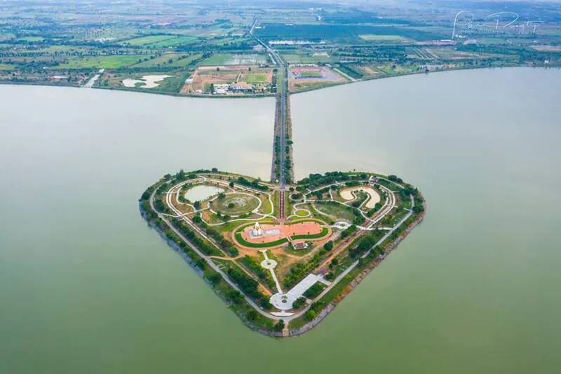
The most recognizable feature of Thung Talay Luang is the heart-shaped island in the middle of the water. From an elevated viewpoint or aerial perspective, the island forms a clear heart shape, which is why many Thai visitors call it the “Sacred Heart-Shaped Land.” The design symbolizes love, unity, reconciliation, and the bond between the people of Sukhothai and their ancestral homeland. It is not only a scenic landmark but also a symbolic place that expresses the emotional identity of the province.
At the center of the island stands a mondop enshrining Phra Phuttha Rattanasiri Sukhothai, a revered Buddha image associated with local faith. This makes the heart-shaped island more than a photo spot. It is also a place where visitors can pay respect, experience a quiet Buddhist atmosphere, and appreciate the spiritual meaning of the site. The image of a Buddha shrine standing in the middle of a wide body of water gives Thung Talay Luang a calm and memorable character, especially during the early morning and late afternoon.
The name “Talay Luang” refers to a vast body of water and connects the site with the historic water landscape of Sukhothai. Ancient Sukhothai was known for its sophisticated use of water systems, including reservoirs, canals, and embankments that supported agriculture and urban life. The modern development of Thung Talay Luang continues that long tradition in a contemporary way, turning a water-retention project into a public landscape that benefits both the community and visitors.
The Thung Talay Luang project began in 2002 as part of a water-management approach designed to reduce flood and drought problems in Sukhothai. The project involved dredging, creating waterways to divert water, and shaping the land so that large volumes of water could be stored and released more effectively. Since Sukhothai is closely connected with the Yom River and surrounding lowland areas, a large water-retention area plays an important role in improving water security for farming communities and nearby settlements.
For travelers, Thung Talay Luang is best experienced slowly. The wide water surface, open sky, and gentle breeze create a relaxing atmosphere. Visitors can walk along the reservoir area, drive around the landscape, cycle, jog, take photographs of the heart-shaped island, or simply sit and enjoy the view. The place is suitable for families, local residents, photographers, cultural travelers, and anyone looking for a quiet open-air destination near Sukhothai town.
The most attractive times to visit are early morning and late afternoon. In the morning, the air is cooler and the light is soft. In the evening, the sunset adds warm colors to the water and makes the central island and shrine stand out beautifully. Many visitors prefer the late afternoon because it allows them to walk, take photos, and watch the atmosphere change as the day turns into evening.
Thung Talay Luang also has a cultural and religious role. The area has been used for Buddhist activities on important days such as Makha Bucha Day and Visakha Bucha Day. When local people gather at the heart-shaped island to pay respect to Phra Phuttha Rattanasiri Sukhothai, the site becomes a living cultural space rather than a purely scenic attraction. This relationship between water, Buddhism, public life, and local identity is one of the most meaningful aspects of the place.
The ecological value of the site is also important. A large freshwater area can support aquatic life, water plants, and birds that depend on wetland environments. Although Thung Talay Luang is a man-made water-management project, its water and green surroundings now function as a local ecological space. It helps create a cooler landscape, provides open public space, and offers opportunities for environmental learning.
The surrounding area reflects the modern development of Sukhothai. Unlike the historical park, which represents the ancient capital, Thung Talay Luang shows how the province continues to use water, land, and public space to serve present-day needs. It is a reservoir, a public park, a religious landmark, a recreational area, and a provincial gathering place. Local residents use it for exercise and relaxation, while visitors often include it as a scenic stop on a wider Sukhothai itinerary.
Travelers interested in Sukhothai history can gain a broader understanding of the province by visiting Thung Talay Luang together with Sukhothai Historical Park, Wat Mahathat, Wat Si Chum, Ramkhamhaeng National Museum, and the historic water systems around the old city. This combination shows that Sukhothai is not only about temples and ancient ruins. It is also about water, agriculture, settlement planning, faith, and community life.
Getting There is convenient by private car, rental car, motorcycle, or local transport from Sukhothai town. The site is located in the Ban Kluai area of Mueang Sukhothai District and can be included in a half-day or full-day route with the historical park and other attractions in the district. Visitors using local transport should arrange the return trip in advance, especially if visiting in the evening after sunset.
Visitors who want to photograph the heart-shaped island should understand that the heart shape is most visible from a high or open angle. From ground level, the atmosphere is still beautiful, but the full heart form may not be as obvious as in aerial photographs. Even so, the bridge, island, shrine, reservoir, and open sky offer several pleasant photo opportunities.
Because the island includes a Buddhist shrine, visitors should behave respectfully when entering the religious area. Modest clothing is recommended when paying respect to the Buddha image. Visitors should avoid loud behavior, keep the area clean, and help preserve the reservoir environment by not leaving waste behind. Thung Talay Luang is both a public space and a sacred landscape, so responsible travel is important.
For trip planning, visitors usually spend around 1 to 2 hours at Thung Talay Luang. This is enough time to walk, take photos, enjoy the view, and pay respect at the shrine. Those who want to jog, cycle, or wait for sunset may spend longer. The site works well as either the first stop of the day before visiting the historical park or the final stop in the evening before returning to Sukhothai town for dinner.
Thung Talay Luang is valuable because it brings together several identities of Sukhothai in one place. It represents water management inspired by royal development concepts, the historic importance of water in Sukhothai, Buddhist faith, local unity, environmental space, and a modern recreational landmark. For foreign travelers, it provides a useful contrast to the ancient ruins and helps explain why water has always been central to life in this part of northern Thailand.
Anyone visiting Sukhothai and looking for a quiet, meaningful, and photogenic destination should consider adding Thung Talay Luang to the itinerary. The heart-shaped island may be the first thing that attracts attention, but the deeper value of the place lies in how it connects people, water, faith, nature, and the continuing story of Sukhothai.
| Name | Thung Talay Luang, Sukhothai Province |
| Location | Ban Kluai and Pak Khwae subdistricts, Mueang Sukhothai District, Sukhothai Province |
| Address | 555 Moo 5, Ban Kluai Subdistrict, Mueang Sukhothai District, Sukhothai 64000, Thailand |
| Coordinates | Approximately 17.0116, 99.7966 |
| Highlights | Heart-shaped island, central Buddhist shrine, Phra Phuttha Rattanasiri Sukhothai, vast reservoir, sunset scenery, and open recreational space |
| History | A royal-inspired monkey-cheek water-retention project developed from 2002 to help manage floodwater and drought in Sukhothai |
| Name Origin | “Talay Luang” refers to a vast body of water, while the heart-shaped land symbolizes love, unity, and faith among the people of Sukhothai |
| Distinctive Features | Total area of about 7,070 rai, including about 3,755 rai of water and 3,495 rai of land used for water retention, public space, and community activities |
| Travel Information | Accessible by private car, rental car, motorcycle, or local transport from Sukhothai town; suitable to combine with Sukhothai Historical Park and nearby city attractions |
| Current Status | Open as a public attraction, recreational area, water-management site, and Buddhist landmark in Sukhothai Province |
| Open Days | Daily |
| Opening Hours | 08.00 – 18.00 |
| Fees | No admission fee |
| Facilities | Parking area, walking space, exercise area, photo spots, and local guide service |
| Main Areas / Zones | 1. Large water-retention reservoir 2. Heart-shaped island 3. Mondop of Phra Phuttha Rattanasiri Sukhothai 4. Reservoir-side walking, jogging, and cycling areas 5. Surrounding public and government-related areas |
| Caretaker / Related Authority | Sukhothai Provincial Administrative Organization and local authorities in Sukhothai Province |
| Nearby Tourist Attractions | 1. Phra Mae Ya Shrine, about 6 km 2. Ramkhamhaeng National Museum, about 8 km 3. Sukhothai Historical Park, about 9 km 4. Wat Mahathat Sukhothai, about 9 km 5. Wat Si Chum, about 11 km |
| Nearby Restaurants | 1. Jae Hae Sukhothai Noodles, about 5 km 2. Thai Ta Pui Noodles, about 5 km 3. Mai Klang Krung, about 5 km 4. Racha Khao Tom 1 Baht, about 5 km 5. Fueng Fah Pla Mae Nam, about 6 km, Tel. 061-2843800, 092-3417926 |
| Nearby Accommodations | 1. EZ House, about 5 km 2. Aen Guy Boutique Hotel, about 5 km 3. Amorn Sukhothai Hotel, about 5 km 4. Ruean Thai Hotel Sukhothai, about 6 km, Tel. 055-612444, 088-2900717 5. Sukhothai Treasure Resort & Spa, about 6 km, Tel. 055-611555, 082-7718973 |
Frequently Asked Questions (FAQ)
Q: Where is Thung Talay Luang located?
A: Thung Talay Luang is located in Ban Kluai and Pak Khwae subdistricts, Mueang Sukhothai District, Sukhothai Province.
Q: What is the main highlight of Thung Talay Luang?
A: The main highlight is the heart-shaped island in the middle of the reservoir, together with the central Buddhist shrine and wide water scenery.
Q: Is there an admission fee for Thung Talay Luang?
A: No. Visitors can enter the area without an admission fee.
Q: What is the best time to visit Thung Talay Luang?
A: Early morning and late afternoon are the best times because the weather is cooler, the light is softer, and the sunset scenery is especially beautiful.
Q: Why is Thung Talay Luang important for water management?
A: It is a monkey-cheek water-retention project designed to receive floodwater, store water for dry periods, and help reduce flood and drought problems in Sukhothai.
Q: What does the heart-shaped island symbolize?
A: The heart-shaped island symbolizes love, unity, reconciliation, faith, and the bond between the people of Sukhothai and their homeland.
Q: How can travelers get to Thung Talay Luang?
A: Travelers can reach the site by private car, rental car, motorcycle, or local transport from Sukhothai town. It is suitable to combine with Sukhothai Historical Park.
Q: How long should visitors spend at Thung Talay Luang?
A: Most visitors spend about 1 to 2 hours walking, taking photos, enjoying the view, and paying respect at the shrine. More time is recommended for sunset or exercise.
 Category: ●Nature and Wildlife
 Group: ●Dam, Reservoir, Lake
Last Update : 5 MonthAgo
 Last Update : 5 MonthAgo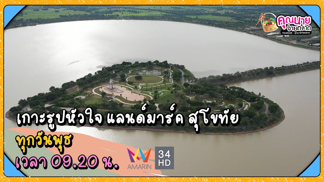
 Click to Access the Navigation Map GPS
Thung Talay Luang Map
Recommend

 Art, Culture and Heritage
 Historical Sites and Monuments(4)
 Landmarks and Memorials(5)
 Art, Craft Centres, Tradition(11)
 Museums(5)
 Places of Worship
 Temple(40)
 Other Sacred Sites(10)
 Suburban Living
 Village, Community(3)
 National Parks and Marine Reserves(3)
 Mountain (Doi)(2)
Dam, Reservoir, Lake(4)
Mountain (Doi)(2)
Dam, Reservoir, Lake(4)
 Waterfalls(8)
 Caves(4)
 River, Canal(2)
 Entertainment and Agricultural
 Farms, Parks and Ecotourism(3)
 Travel Articles, Recipes
 Travel Review, Food Review(1)


